
Ormont-Dessus
| Ormont-Dessus | |
|---|---|
.svg) |
|
| State : |
|
| Canton : |
|
| District : | Aigle |
| BFS no. : | 5411 |
| Postal code : | 1865 Les Diablerets 1864 Vers-l'Eglise |
| Coordinates : | 578 400 / 133188 |
| Height : | 1163 m above sea level M. |
| Height range : | 1006–3209 m above sea level M. |
| Area : | 61.61 km² |
| Residents: | 1448 (December 31, 2018) |
| Population density : | 24 inhabitants per km² |
| Website: | www.ormont-dessus.ch |
 Les Diablerets |
|
| Location of the municipality | |
  |
|
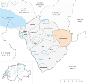
Ormont-Dessus is a municipality in the district of Aigle in the canton of Vaud in Switzerland . The former German names Ormund and Ulmenthal are no longer used today. The most famous district is the Les Diablerets holiday village .
geography

Ormont-Dessus is about 15 km east of the district capital Aigle (as the crow flies). The community, which consists of several districts, is located in the upper part of the Grande Eau valley , in the Les Ormonts valley in the Vaudois Alps, at the northwest foot of the Les Diablerets massif .
The area of the 61.5 km² municipal area covers a section of the Vaudois Alps. The central part of the area is occupied by the wide basin of the Grande Eau, into which the right tributary Le Dar flows at Les Diablerets . The valley of Les Ormonts is bordered in the north by the mountain range with Pic Chaussy ( 2351 m above sea level ), Châtillon ( 2478 m above sea level ), Le Tarent ( 2548 m above sea level ), La Para ( 2540 m above sea level). M. ) and Cape au Moine ( 2352 m above sea level ). On the southern slope of this chain there are extensive alpine meadows.
To the south of the valley, the municipality extends to the Tête de Meilleret ( 1938 m above sea level ) and the mountain peaks of the limestone massif of Les Diablerets: Culan ( 2789 m above sea level ), Sommet des Diablerets (at 3210 m above sea level) . The highest point of Ormont-Dessus), Sex Rouge ( 2971 m above sea level ) and Becca d'Audon ( Oldenhorn , 3123 m above sea level ). The Tsanfleuron glacier is located at the height of the Diablerets massif (mostly outside the municipal area). The source streams of the Grande Eau are fed by the firn fields Glacier de Pierredar , Mauvais Glacier , Glacier de Prapio , Glacier du Dar and Glacier du Sex Rouge, which lie on the steep northern slopes of the massif .
To the east, the municipal area extends over the pass of the Col du Pillon (with the Retaudsee ), which forms the European main watershed between the Rhone and the Rhine , into the catchment area of the Saane . In 1997, 4% of the municipal area was in settlements, 31% in forests and woodlands, 33% in agriculture and around 32% was unproductive land.
Villages of Ormont Dessus
The municipality of Ormont-Dessus consists of the following villages and hamlets (there is no place with the same name as the municipality):
- Les Diablerets, 1163 m above sea level M. , administrative center of Ormont-Dessus, holiday village in a wide basin of the Grande Eau at the foot of the Les Diablerets mountain range of the same name . The ski competitions of the 2020 Winter Youth Olympic Games will be held in Les Diablerets .
- Le Plan, 1150 m above sea level M. , in the valley of the Grande Eau to the west of Les Diablerets
- Vers-l'Eglise, 1128 m above sea level M. , on the left side of the valley the Grande Eau
- Le Rosex, 1095 m above sea level M. , on the right side of the valley of the Grande Eau
Neighboring municipalities of Ormont-Dessus are Château-d'Oex , Ormont-Dessous , Ollon , Gryon and Bex in the canton of Vaud, Conthey and Savièse in the canton of Valais and Gsteig near Gstaad in the canton of Bern .
population
With 1,448 inhabitants (as of December 31, 2018), Ormont-Dessus is one of the medium-sized municipalities in the canton of Vaud. 89.5% of the residents are French-speaking, 3.6% German-speaking and 2.0% Portuguese-speaking (as of 2000). The population of Ormont-Dessus was 1061 in 1870 and 1092 in 1900. In the course of the first half of the 20th century, the population decreased to 921 inhabitants by 1960. Since then, there has been significant population growth, particularly during the 1990s.
economy
Ormont-Dessus was a predominantly agricultural village until the end of the 19th century. With the improved transport connections since around 1870, the community gradually developed into a holiday and tourist destination.
Even today, dairy farming and animal husbandry have an important place in the income structure of the population. In the pre-alpine areas there are extensive alpine pastures for the summer grazing of the livestock. Further jobs are available in local small businesses and especially in the service sector. In addition to everyday goods, the trade is geared towards the needs of tourism. The Mountain Film Festival (Festival International du Film Alpin) has been held in Les Diablerets since 1969. The local museum Musée des Ormonts and since 1983 the large congress center are located in the village.
tourism
The village of Les Diablerets is now geared towards both summer and winter tourism. The alpine meadows and mountains on the northern side of the valley of Les Ormonts invite you to take long walks and mountain hikes. The surrounding mountains have been accessed by cable cars since the 1950s. There are ski lifts on Alp Isenau and on the slope of Tête de Meilleret. In 1964, with the opening of the mountain railways (three sections) on the Sex Rouge ( 2940 m above sea level ), the glaciers of the Diablerets massif were made accessible to tourism. You can ski on the Tsanfleuron Glacier well into summer.
traffic

The community is very well developed in terms of traffic. Les Diablerets is located on the main road that leads from Aigle over the Col du Pillon to Gstaad in the western Bernese Oberland. There is a direct road connection with the excursion area Villars-sur-Ollon via the Col de la Croix .
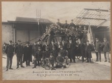
Since December 22, 1913, Les Diablerets has been connected to the Chemin de fer Aigle-Sépey-Diablerets narrow-gauge railway operated by the Transports Publics du Chablais . Bus routes from Les Diablerets via the Col du Pillon to Gstaad and Schönried as well as via the Col de la Croix to Villars-sur-Ollon ensure the fine distribution of public transport.
Les Diablerets is a member of the Alpine Pearls , which advocate environmentally friendly mobility in the Alpine region.
history
The valley of Les Ormonts was probably reclaimed between the 7th and 9th centuries and settled by residents from the Rhône valley. The area belonged to the Abbey of Saint-Maurice , which came under the sovereignty of the Counts of Savoy in the 13th century. The rear part of the valley with Les Diablerets was called La Joux d'Ormonts at that time , Outre Joux in the 15th century and Ormont-Dessus since the 16th century .
With the conquest of Aigle by Bern in 1476, Ormont-Dessus came under the administration of the Aigle governorate . Against the tough resistance of the valley population, the Reformation was introduced in 1529 . When the ancien régime collapsed in 1798, the population resisted taking possession by the French and Vaudois troops. There were armed conflicts before the valley community finally capitulated. As a result, Ormont-Dessus belonged to the canton of Léman from 1798 to 1803 during the Helvetic Republic , which then became part of the canton of Vaud when the mediation constitution came into force . In 1798 it was assigned to the Aigle district.
With the improved transport connections, the economic boom began around 1850 as a tourist destination. The first to be opened in 1856 was the Grand Hôtel, then still known as the Hôtel des Diablerets. A fire broke out in this building on the night of June 5th to 6th, 1956 , killing 12 people.
coat of arms
Description : In blue over a green three-mountain a golden crescent moon and above a five-pointed golden star .
Attractions
The parish church of Saint-Théodule, consecrated in 1456, is located in the Vers-l'Eglise district. The single-nave building with a front tower and a polygonal choir was redesigned in baroque style around 1708 . Les Diablerets is characterized by numerous hotel and chalet buildings.
photos

Rue de la Gare

Collège (school house)
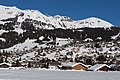
Les Diablerets


Web links
- Official website of the municipality of Ormont-Dessus (French)
- Website of the Les Diablerets tourist region
- Mary-Claude Busset-Henchoz: Ormont-Dessus. In: Historical Lexicon of Switzerland .
- Aerial views of the village and its surroundings
Individual evidence
- ↑ Permanent and non-permanent resident population by year, canton, district, municipality, population type and gender (permanent resident population). In: bfs. admin.ch . Federal Statistical Office (FSO), August 31, 2019, accessed on December 22, 2019 .
- ↑ Holidays in Les Diablerets with the mobility guarantee of the Alpine Pearls. Retrieved March 24, 2017 .
Aigle | Bex | Chessel | Corbeyrier | Gryon | Lavey-Morcles | Leysin | Noville | Ollon | Ormont lingerie | Ormont-Dessus | Rennaz | Roche (VD) | Villeneuve (VD) | Yvorne
Former parishes: Lavey | Morcles
Canton of Vaud | Districts of the canton of Vaud | Municipalities of the canton of Vaud