
Gryon
| Gryon | |
|---|---|
.svg) |
|
| State : |
|
| Canton : |
|
| District : | Aigle |
| BFS no. : | 5405 |
| Postal code : | 1882 |
| Coordinates : | 571025 / 124758 |
| Height : | 1114 m above sea level M. |
| Height range : | 709–2623 m above sea level M. |
| Area : | 15.22 km² |
| Residents: | 1332 (December 31, 2018) |
| Population density : | 88 inhabitants per km² |
| Website: | www.gryon.ch |
 Gryon |
|
| Location of the municipality | |
  |
|
Gryon is a municipality in the district of Aigle in the canton of Vaud in Switzerland .
geography

Gryon is 1114 m above sea level. M. , 9 km southeast of the district capital Aigle (air line). The clustered village extends on a southern slope high above the valley of the Avançon , west of the massif of Les Diablerets , in a panoramic position around 700 m above the Rhône plain.
The area of the 15.2 km² municipal area comprises a section of the Vaudois Alps. The area is bordered by the Avançon stream in the south and the Gryonne torrent in the north . In between rises the ridge of Gryon, which is on the Plan Sépey plateau 1246 m above sea level. M. achieved. This ridge continues to the east via La Barboleusaz and Les Chaux to the rocky ridge with the peaks of Le Coin ( 2229 m above sea level ) and Pointes de Châtillon ( 2368 m above sea level ). On the western slope of the Culan , which already belongs to the Diablerets massif, at 2620 m above sea level. M. reached the highest point of Gryon. Alp Taveyanne lies at the northern foot of this mountain ridge in the headwaters of the Gryonne. In 1997, 10% of the municipal area was settled, 51% forest and woodland, 30% agriculture and a little less than 9% was unproductive land.
Gryon includes the hamlets of Rabou ( 1130 m above sea level ) above the Avançon valley and La Barboleusaz ( 1211 m above sea level ) on the ridge between Gryonne and Avançon, extensive holiday home areas in the area of Les Frasses, the alpine settlement of Taveyanne ( 1647 m above sea level ) as well as some individual farms. Neighboring municipalities of Gryon are Bex , Ollon and Ormont-Dessus .
population
With 1,332 inhabitants (as of December 31, 2018), Gryon is one of the medium-sized municipalities in the canton of Vaud. 87.6% of the residents are French-speaking, 4.0% German-speaking and 3.2% English-speaking (as of 2000). The population of Gryon was 403 in 1850 and 480 in 1900. During the 20th century, the population grew steadily (1960: 706 inhabitants).
Economy and tourism
Until the second half of the 19th century, Gryon was a predominantly agricultural village. After 1875, with the opening of the road from the Rhône valley to Gryon, it began to develop into a tourist destination.
Today, dairy farming , cattle breeding and forestry have only a minor role in the employment structure of the population. Further jobs are available in local small businesses and especially in the service sector. The La Peuffeyre power station, operated by the Forces Motrices de l'Avançon, has been located in the Avançon Valley since 1895.
In addition to everyday goods, Gryon's trade is mainly geared towards tourism. Together with the neighboring village of Villars-sur-Ollon , Gryon became an important tourist destination with summer and winter tourism. Since the 1980s in particular, a modern tourist center and numerous hotels, holiday camps and weekend house settlements have been built in the area of La Barboleusaz. The height of La Chaux is accessible by a mountain railway. In winter, numerous ski lifts are in operation, which also ensure a transition to the Villars-sur-Ollon ski area.
In the last few decades the village has also developed into a residential community thanks to its attractive location. Many workers are commuters who work in the larger municipalities of the Rhône Valley.
traffic
The community is located off the main thoroughfares on a connecting road from Bex to Villars-sur-Ollon . The village is connected to the public transport network by the cog railway, which has been running from Bex to Gryon since June 4, 1900 (the continuation to Villars-sur-Ollon was put into operation on June 10, 1901).
history
The first written mention of the place took place in 1189 under the name Griuns ; until 1867 the spelling Grion was also used. Gryon belonged to the Bex area before 1189, but then came into the possession of the Abbey of Saint-Maurice through a gift from Peter von Griuns .
With the conquest of Aigle by Bern in 1476, Gryon came under the administration of the Aigle governorate . However, the village retained a special position, as the judicial rights remained with Saint-Maurice. The Reformation was introduced in Gryon in 1539. Since the 17th century there were repeated disputes with Bex, who had been awarded the rights to use the Gryon forests for the operation of its salt mines in Bern. On July 19, 1719, numerous houses were destroyed by a fire.
After the collapse of the Ancien Régime , Gryon belonged to the canton of Léman from 1798 to 1803 during the Helvetic Republic , which then became part of the canton of Vaud when the mediation constitution came into force . In 1798 it was assigned to the Aigle district.
Gryon experienced an economic boom in the second half of the 19th century. Due to the improved transport connections (road and rack railway) the village developed into a place of relaxation. It was the residence of the poet Juste Olivier from 1871 to 1876 .
Sons and Daughters of Gryon
- Benjamin Vallotton (1877–1962), writer
coat of arms
Description : A silver trefoil cross (Lazarus cross) hovers over two gold-stemmed crossed axes with silver edges.
Attractions
The Saint-Jean church has been mentioned since the 13th century. It was largely destroyed in the village fire and was rebuilt from 1722 to 1724. The old town center of Gryon has largely retained the typical character of a mountain village with farmhouses from the 18th and 19th centuries.

Temple Saint-Jean
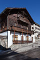
Old post


literature
Jean-Charles Kollros ea: Gryon, huit siècles et plus! Territet-Montreux 1989
Web links
- Official website of the municipality of Gryon (French)
- Denyse Raymond: Gryon. In: Historical Lexicon of Switzerland .
- Website of the Villars-Gryon tourist region
- Aerial views of the village and its surroundings
Individual evidence
- ↑ Permanent and non-permanent resident population by year, canton, district, municipality, population type and gender (permanent resident population). In: bfs. admin.ch . Federal Statistical Office (FSO), August 31, 2019, accessed on December 22, 2019 .
Aigle | Bex | Chessel | Corbeyrier | Gryon | Lavey-Morcles | Leysin | Noville | Ollon | Ormont lingerie | Ormont-Dessus | Rennaz | Roche (VD) | Villeneuve (VD) | Yvorne
Former parishes: Lavey | Morcles
Canton of Vaud | Districts of the canton of Vaud | Municipalities of the canton of Vaud