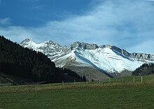
Parc naturel regional Gruyère Pays-d'Enhaut
The Parc naturel régional Gruyère Pays-d'Enhaut is a park of national importance in Switzerland . Its territory includes untouched nature and landscapes shaped by the alpine economy.
geography
The park in western Switzerland was designated in 2012 and extends over the Vaudois and Freiburg Pre-Alps . Its territory between Montreux , Bulle and Gstaad extends over 630 square kilometers with 17 municipalities and includes the Jaunbachtal and Intyamon regions in the south of the Gruyère region ( canton of Friborg ), the Pays-d'Enhaut as well as the Rochers de Naye and the heights of the Vaudois Riviera ( Canton of Vaud ). The municipalities in four regions are:
- Jaunbach valley : Val-de-Charmey , Châtel-sur-Montsalvens , Crésuz , Jaun and the village of Abländschen
- Intyamon : Gruyère , Bas-Intyamon , Grandvillard , Haut-Intyamon
- Pays-d'Enhaut : Les Mosses , Château-d'Oex , Ormont-Dessous , Rossinière , Rougemont
- on Lake Geneva : the heights of the municipalities of Corbeyrier , Montreux , Veytaux (including the castle of Chillon ) and Villeneuve .
The municipalities of Corbeyrier, Gruyère, Jaun and Saanen für Abländschen were only accepted into the Association of the Regional Nature Park in 2020. 16,000 people live in the park, which corresponds to around 25 people per square kilometer. The height above sea level ranges from 374 to 2548 m at Le Taranto . There are three Pro Natura nature reserves in the park : La Pierreuse , Vanil Noir and Le Larzey .
Web links
Individual evidence
- ↑ Parc naturel régional Gruyère Pays-d'Enhaut , Swiss Park Network, accessed on August 13, 2020.
- ↑ a b Le Parc en bref , www.gruyerepaysdenhaut.ch, accessed on August 13, 2020.
Coordinates: 46 ° 28 ' N , 7 ° 6' E ; CH1903: 574395 / one hundred and forty-six thousand six hundred and five

