
Massa (Tuscany)
| Massa | ||
|---|---|---|

|
|
|
| Country | Italy | |
| region | Tuscany | |
| province | Massa-Carrara (MS) | |
| Coordinates | 44 ° 1 ' N , 10 ° 8' E | |
| height | 65 m slm | |
| surface | 94 km² | |
| Residents | 68,514 (Dec. 31, 2019) | |
| Population density | 729 inhabitants / km² | |
| Post Code | 54100 | |
| prefix | 0585 | |
| ISTAT number | 045010 | |
| Popular name | Massesi | |
| Patron saint | San Francesco d'Assisi (October 4th) | |
| Website | Massa | |
 View of Massa |
||

Massa is an Italian city with 68,514 inhabitants (as of December 31, 2019) in Tuscany . It is the capital of the province of Massa-Carrara .
geography
.svg)
Location and neighboring communities
Massa is about 115 km west of Florence and extends from the Ligurian coast to the Apuan Alps . The highest point of the municipality is the Monte Tambura with 1890 m above sea level. About half of the municipal area lies in the coastal plain, the other half is formed by hills and mountains. Massa is the seat of the Roman Catholic diocese of Massa Carrara-Pontremoli and is located on the Via Francigena , the old pilgrimage route from England to Rome.
The city of Carrara is located directly north of Massa . The other neighboring municipalities are Fivizzano , Minucciano (LU), Montignoso , Seravezza (LU), Stazzema (LU) and Vagli Sotto (LU).
City structure

Massa is divided into five administrative districts (circoscrizioni).
- Zona Montana
- Destra Frigido
- Centro Città
- Largo Viale Roma
- Marina di Massa
The numerous fractions (districts) are partly districts of Massa and Marina di Massa, partly villages in the mountains: Altagnana, Alteta, Antona, Baita, Bargana, Bergiola, Borgo del Ponte, Bozzone, Caglieglia, Campareccia, Canevara, Capaccola, i Capuccini, Casette, Castagnara, Castagnetola, Castagnola, Cervara, Cinque Vie, Ciremea, Codupino, Cupido, Forno, Le Grazie, Gronda, Grondini, Guadine, Le Iare, Lavacchio, Marina di Massa, Mirteto, Monte Pepe, Ortola, Pariana, La Partaccia, Pian della Fioba, Poggiolo, Poggioletto, il Ponte, Poveromo, Poveromo Macchie, Quercioli, Redicesi, Resceto, Ricortola, Rinchiostra, Rocca, Romagnano, Ronchi, San Carlo Terme, San Cristoforo, Santa Lucia, Il Santo, Sei ponti , Turano, Vergheto, Volpigliano, Zecca.
At the time of Italian fascism , Massa was combined with the cities of Carrara and Montignoso to form the municipality of Apuania in 1938 . The community was dissolved again in 1946, since then Massa has been independent again.
Old town
The old town of Massa is about two and a half kilometers from the coast on the Frigido River, which flows into the Tyrrhenian Sea at the seaside resort of Marina di Massa .
The historic Massa includes the upper town center, dominated by the castle, and the lower town with the cathedral , which was built in the 16th century and dates back to a church from 1389. The center is lined with orange trees Piazza degli Aranci . On the south side of the square is the Palazzo Cybo-Malaspina (or Palazzo Ducale ) with a facade accentuated in red and white in Baroque style, which is why it is also called Palazzo Rosso . The imposing building bears witness to the former rule of the Malaspina family from the Cinquecento and is now the seat of the government of the province of Massa-Carrara .

The Rocca Malaspina castle
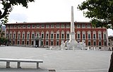
Piazza degli Aranci with the Palazzo Ducale

The cathedral

Interior of the cathedral

Piazza Mercurio
Piazza Giuseppe Garibaldi

The city gate Porta Martana
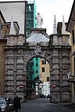
The city gate Porta del Salvatore
.JPG)


.jpg)
.JPG)
Culture
The National Esperanto Library of Italy was founded in 1972. It has been publicly available since 1994.
Sports
Marina di Massa was a stage destination of the Giro d'Italia in 1988, 1996 and 2007 .
economy
Massa, along with the Carrara region, is the main square for Tuscan marble quarrying .
traffic
The narrow plain between the Apuan Alps and the Mediterranean has always been an important traffic route on the Italian west coast. The Roman Via Aurelia , today's State Road 1, ran here . The Pisa – Genoa railway line was built in the 19th century . The A12 motorway also runs through Massa. Nearby is the Massa-Cinquale airfield for general aviation .
Twin cities
- Bad Kissingen in Lower Franconia ( Germany ), since 1960
- Vernon in Normandy ( France )
- Nowy Sącz in the Lesser Poland Voivodeship ( Poland ), since 2007
Bad Kissingen and Vernon also have a partnership with each other.
Personalities
- Francesco Colombini (1588–1671), Baroque composer and Canon
- Johann Brunetti (1646–1703), titular bishop of Lacedaemonia and auxiliary bishop in Breslau
- Camillo Cibo (1681-1743), cardinal
- Pietro Alessandro Guglielmi (1728–1804), composer
- Silvio Baldini (* 1958), football coach
- Alberico Evani (* 1963), football player and coach
- Giovanni Francini (born 1963), football player
- Roberto Mussi (* 1963), football player
- Andrea Coda (* 1985), football player
- Andrea Manfredi (1992–2018), racing cyclist
- Nicolò Zaniolo (* 1999), football player
Web links
Individual evidence
- ↑ Statistiche demografiche ISTAT. Monthly population statistics of the Istituto Nazionale di Statistica , as of December 31 of 2019.
- ↑ massacarrara-live.it , accessed February 26, 2010

Aulla | Bagnone | Carrara | Casola in Lunigiana | Comano | Filattiera | Fivizzano | Fosdinovo | Licciana Nardi | Massa | Montignoso | Mulazzo | Podenzana | Pontremoli | Tresana | Villafranca in Lunigiana | Zeri
← Previous location: Luna (Italy) 14.8 km | Massa (Tuscany) | Next town: Pietrasanta 15.8 km →
![]() Canterbury |
Dover |
Calais |
Wissant |
Guînes |
Licques |
Wisques |
Thérouanne |
Auchy-au-Bois |
Bruay-la-Buissière |
Arras |
Bapaume |
Peronne |
Doingt |
Seraucourt-le-Grand |
Tergnier |
Laon |
Bouconville-Vauclair |
Corbeny |
Hermonville |
Reims |
Trépail |
Châlons-en-Champagne |
Cool |
Brienne-le-Château |
Bar-sur-Aube |
Châteauvillain |
Blessonville |
Langres |
Humes-Jorquenay |
Coublanc |
Grenant |
Dampierre-sur-Salon |
Savoyeux |
Seveux |
Gy |
Cussey-sur-l'Ognon |
Besançon |
Étalans |
Chasnans |
Nods |
Ouhans |
Pontarlier |
Yverdon-les-Bains |
Orbe |
Lausanne |
Cully |
Vevey |
Montreux |
Villeneuve |
Aigle |
Saint-Maurice |
Martigny |
Orsières |
Bourg-Saint-Pierre |
Great St. Bernhard |
Saint-Rhémy-en-Bosses |
Saint-Oyen |
Étroubles |
Gignod |
Aosta |
Saint-Christophe |
Quart |
Nut |
Verrayes |
Chambave |
Saint-Denis |
Châtillon |
Saint-Vincent |
Montjovet |
Issogne |
Verrès |
Arnad |
Hône |
Bard |
Donnas |
Pont-Saint-Martin |
Carema |
Settimo Vittone |
Borgofranco d'Ivrea |
Montalto Dora |
Ivrea |
Cascinette d'Ivrea |
Burolo |
Bollengo |
Palazzo Canavese |
Piverone |
Azeglio |
Viverone |
Roppolo |
Cavaglià |
Santhià |
San Germano Vercellese |
Olcenengo |
Salasco |
Sali Vercellese |
Vercelli |
Palestro |
Robbio |
Nicorvo |
Castelnovetto |
Albonese |
Mortara |
Cergnago |
Tromello |
Garlasco |
Gropello Cairoli |
Villanova d'Ardenghi |
Zerbolò |
Carbonara al Ticino |
Pavia |
Valle Salimbene |
Linarolo |
Belgioioso |
Torre de 'Negri |
Costa de 'Nobili |
Santa Cristina e Bissone |
Miradolo Terme |
Chignolo Po |
San Colombano al Lambro |
Orio Litta |
Senna Lodigiana |
Calendasco |
Rottofreno |
Piacenza |
Podenzano |
San Giorgio Piacentino |
Pontenure |
Carpaneto Piacentino |
Cadeo |
Fiorenzuola d'Arda |
Chiaravalle della Colomba |
Alseno |
Busseto |
Fidenza |
Costamezzana |
Noceto |
Medesano |
Fornovo di Taro |
Terenzo |
Berceto |
Pontremoli |
Filattiera |
Villafranca in Lunigiana |
Bagnone |
Licciana Nardi |
Aulla |
Santo Stefano di Magra |
Sarzana |
Castelnuovo Magra |
Ortonovo |
Luni |
Fosdinovo |
Carrara |
Massa |
Montignoso |
Seravezza |
Pietrasanta |
Camaiore |
Lucca |
Capannori |
Porcari |
Montecarlo |
Altopascio |
Castelfranco di Sotto |
Santa Croce sull'Arno |
Ponte a Cappiano |
Fucecchio |
San Miniato |
Castelfiorentino |
Coiano |
Montaione |
Gambassi Terme |
San Gimignano |
Colle di Val d'Elsa |
Badia a Isola |
Monteriggioni |
Siena |
Monteroni d'Arbia |
Ponte d'Arbia |
Buonconvento |
Montalcino |
Torrenieri |
San Quirico d'Orcia |
Bagno Vignoni |
Castiglione d'Orcia |
Radicofani |
San Casciano dei Bagni |
Abbadia San Salvatore |
Piancastagnaio |
Ponte a Rigo |
Proceno |
Acquapendente |
Grotte di Castro |
San Lorenzo Nuovo |
Bolsena |
Montefiascone |
Viterbo |
Ronciglione |
Vetralla |
Capranica |
Sutri |
Monterosi |
Nepi |
Mazzano Romano |
Campagnano di Roma |
Formello |
La Storta |
Rome
Canterbury |
Dover |
Calais |
Wissant |
Guînes |
Licques |
Wisques |
Thérouanne |
Auchy-au-Bois |
Bruay-la-Buissière |
Arras |
Bapaume |
Peronne |
Doingt |
Seraucourt-le-Grand |
Tergnier |
Laon |
Bouconville-Vauclair |
Corbeny |
Hermonville |
Reims |
Trépail |
Châlons-en-Champagne |
Cool |
Brienne-le-Château |
Bar-sur-Aube |
Châteauvillain |
Blessonville |
Langres |
Humes-Jorquenay |
Coublanc |
Grenant |
Dampierre-sur-Salon |
Savoyeux |
Seveux |
Gy |
Cussey-sur-l'Ognon |
Besançon |
Étalans |
Chasnans |
Nods |
Ouhans |
Pontarlier |
Yverdon-les-Bains |
Orbe |
Lausanne |
Cully |
Vevey |
Montreux |
Villeneuve |
Aigle |
Saint-Maurice |
Martigny |
Orsières |
Bourg-Saint-Pierre |
Great St. Bernhard |
Saint-Rhémy-en-Bosses |
Saint-Oyen |
Étroubles |
Gignod |
Aosta |
Saint-Christophe |
Quart |
Nut |
Verrayes |
Chambave |
Saint-Denis |
Châtillon |
Saint-Vincent |
Montjovet |
Issogne |
Verrès |
Arnad |
Hône |
Bard |
Donnas |
Pont-Saint-Martin |
Carema |
Settimo Vittone |
Borgofranco d'Ivrea |
Montalto Dora |
Ivrea |
Cascinette d'Ivrea |
Burolo |
Bollengo |
Palazzo Canavese |
Piverone |
Azeglio |
Viverone |
Roppolo |
Cavaglià |
Santhià |
San Germano Vercellese |
Olcenengo |
Salasco |
Sali Vercellese |
Vercelli |
Palestro |
Robbio |
Nicorvo |
Castelnovetto |
Albonese |
Mortara |
Cergnago |
Tromello |
Garlasco |
Gropello Cairoli |
Villanova d'Ardenghi |
Zerbolò |
Carbonara al Ticino |
Pavia |
Valle Salimbene |
Linarolo |
Belgioioso |
Torre de 'Negri |
Costa de 'Nobili |
Santa Cristina e Bissone |
Miradolo Terme |
Chignolo Po |
San Colombano al Lambro |
Orio Litta |
Senna Lodigiana |
Calendasco |
Rottofreno |
Piacenza |
Podenzano |
San Giorgio Piacentino |
Pontenure |
Carpaneto Piacentino |
Cadeo |
Fiorenzuola d'Arda |
Chiaravalle della Colomba |
Alseno |
Busseto |
Fidenza |
Costamezzana |
Noceto |
Medesano |
Fornovo di Taro |
Terenzo |
Berceto |
Pontremoli |
Filattiera |
Villafranca in Lunigiana |
Bagnone |
Licciana Nardi |
Aulla |
Santo Stefano di Magra |
Sarzana |
Castelnuovo Magra |
Ortonovo |
Luni |
Fosdinovo |
Carrara |
Massa |
Montignoso |
Seravezza |
Pietrasanta |
Camaiore |
Lucca |
Capannori |
Porcari |
Montecarlo |
Altopascio |
Castelfranco di Sotto |
Santa Croce sull'Arno |
Ponte a Cappiano |
Fucecchio |
San Miniato |
Castelfiorentino |
Coiano |
Montaione |
Gambassi Terme |
San Gimignano |
Colle di Val d'Elsa |
Badia a Isola |
Monteriggioni |
Siena |
Monteroni d'Arbia |
Ponte d'Arbia |
Buonconvento |
Montalcino |
Torrenieri |
San Quirico d'Orcia |
Bagno Vignoni |
Castiglione d'Orcia |
Radicofani |
San Casciano dei Bagni |
Abbadia San Salvatore |
Piancastagnaio |
Ponte a Rigo |
Proceno |
Acquapendente |
Grotte di Castro |
San Lorenzo Nuovo |
Bolsena |
Montefiascone |
Viterbo |
Ronciglione |
Vetralla |
Capranica |
Sutri |
Monterosi |
Nepi |
Mazzano Romano |
Campagnano di Roma |
Formello |
La Storta |
Rome![]()
![]()
![]()