Via Aurelia

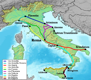
The Via Aurelia (German Aurelische Straße ) is a Roman road , which the censor Gaius Aurelius Cotta in the year 241 BC. Was commissioned. In the final stage, it ran from Rome along the coast to Pisae (Pisa) or Luna (Luni).
Only later the name Via Aurelia on its continuation, the coastal part of which was Via Aemilia Scauri and the Via Julia Augusta , expanded, making the Via Aurelia finally up behind Arelate extended (Arles) in order there following the Via Domitia to Find. The distance from Rome to Arles is 962 kilometers.
In modern Italy, the Via Aurelia is an important trunk road as State Road 1 , SS 1 Via Aurelia , which essentially connects Rome with the port city of Civitavecchia on the ancient route and continues along the coast to Ventimiglia and France.
Course in Italy
The Via Aurelia was originally planned as a connection road to Cerveteri , but was then extended to the military colony of Cosa (now part of Orbetello ).
It originally began in Rome at the Pons Aemilius , the oldest stone bridge over the Tiber. With the construction of the Aurelian Wall , she left the city through Porta Aurelia , today's Porta San Pancrazio , and ran from there to the west.
With the construction of the Pons Aelius in 134 AD, the beginning of the road was relocated and the new route was called Via Aurelia nova . The old street was named Via Aurelia vetus or Via Aurelia antica . The name Porta Aurelia also became common for the Porta Cornelia on Pons Aelius, built in the 3rd century .
The modern Via Aurelia begins at the (walled) Porta Cavalleggeri in the Leonine Wall south of St. Peter's Basilica . It runs along the route of the ancient Via Aurelia nova to the west. The Via Aurelia Antica begins today at the Porta San Pancrazio, runs north of the Villa Doria Pamphili and shortly thereafter joins the Via Aurelia. This is the main access road of the XVIII. Aurelia Municipality .
From the modern bypass road Circonvallazione Aurelia , Via Aurelia is classified as a state road Strada Statale 1 Via Aurelia (SS 1) . The Kilometrierung however, begins as the consular usual at the Piazza Venezia . It reaches the GRA motorway ring at junction 1 Aurelia and has multiple lanes up to the Torrimpietra junction on the A12 Autostrada Azzurra .
From Torrimpietra (km 22), district of Fiumicino , the Via Aurelia runs along the coast and touches or grazes the following places or landscapes in its further course:
- Palidoro (km 26)
- Ladispoli (km 45)
- Cerveteri (km 46)
- Santa Severa (ancient Pyrgi , km 51)
- Santa Marinella (km 60)
- Civitavecchia (km 71)
- Terme Taurine (ancient Aquae Tauri , km 72)
- Tarquinia (km 101)
- the Maremma
- Capalbio (km 132)
- Orbetello (km 141)
- Talamone (km 165)
- Vetulonia (km 207)
- Populonia (km 249)
- at Vada Volterrana , the Via Aurelia leaves the coast today and heads towards Pisa
- Pisa (km 336 - Pisa was a port city at the mouth of the Arno in Roman times )
- Viareggio (km 367)
- Luni (km 399)
- Genoa (km 501)
- Savona (km 546)
- Albenga (km 588)
- Sanremo (km 640)
- Ventimiglia (km 655)
Course in France
In France, the Via Aurelia crosses the cities of Nice, Marseille and Arles; northwest of Arles it then found connection to the Via Domitia. It follows the Grande Corniche on the Côte d'Azur , then today's Route nationale 7 to Aix-en-Provence , from there to two routes near Arles:
- Cap Martin
- La Turbie
- Cimiez ( Cemenelum , km 687, today part of Nice )
- Antibes ( Antipolis )
- Fréjus ( Forum Iulii , km 742 - here the Via Aurelia leaves the coast one more time and runs up the Argens valley to Vidauban )
- Le Muy
- Vidauban ( forum voconii )
- Le Luc
- Cabasse ( Matavo )
- Brignoles
- Tourves ( Turris )
- Aix-en-Provence ( Aquae Sextiae )
- A southern branch began in Aix
- Marseille ( Massilia )
- Vitrolles
- Fos-sur-Mer and
- Arles ( Arelate , km 962 - the city was reached from the southeast via the Alyscamps and the subsequent Avenue des Alyscamps )
- Saint-Gabriel ( Ernaginum , the largest Gallo-Roman road junction, where the Via Aurelia meets the Via Domitia, and the two branches meet again, today the southeastern district of Tarascon ).
- as well as a northwest branch to
- Eguilles
- Salon-de-Provence ( Pisaris )
- Aureille (!)
- Mouriès
- Maussane-les-Alpilles (the Via Aurelia runs south of the village)
- Paradou
- Saint-Gabriel (district of Tarascon ).
