Orbetello
| Orbetello | ||
|---|---|---|

|
|
|
| Country | Italy | |
| region | Tuscany | |
| province | Grosseto (GR) | |
| Coordinates | 42 ° 27 ' N , 11 ° 13' E | |
| height | 3 m slm | |
| surface | 226.98 km² | |
| Residents | 14,683 (Dec. 31, 2019) | |
| Population density | 65 inhabitants / km² | |
| Post Code | 58010 58015 | |
| prefix | 0564 | |
| ISTAT number | 053018 | |
| Popular name | Orbetellani | |
| Patron saint |
San Biagio (February 3rd) |
|
| Website | Orbetello | |
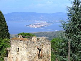
 The lagoon town Orbetello from Monte Argentario seen from |
||
Orbetello is an Italian city with 14,683 inhabitants (as of December 31, 2019) in the province of Grosseto in Tuscany .
geography
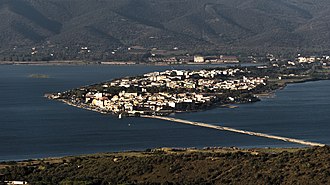
Orbetello is now on the middle of the three tomboli that connect Monte Argentario with the Tuscan mainland. The approximately four kilometer long connecting dam on which the road runs was not artificially built up until 1824. In ancient times, Orbetello was on an island. Two more tomboli, which represent connections between Monte Argentario and the mainland and enclose the Orbetello lagoon, were created over the centuries. On the northern Tombolo di Giannella , the road leading from Albinia to Monte Argentario runs, flanked by campsites and apartment complexes. The southern one ( Tombolo di Feniglia ), on which Caravaggio's body was found on July 18, 1610 , is largely natural. The extensive pine forests and sandy beaches are not accessible for cars and are a habitat for fallow and wild boar.
The Orbetello lagoon was partially silted up during the Middle Ages by the quicksand from the headlands, as well as mud and debris that the Albegna River brought from the mountains. On the other hand, there is a certain exchange with the sea water through a canal system. The mixture of fresh and salt water created a landscape similar to that created by the Ombrone River in the Parco Naturale della Maremma . This approx. 800 hectare part of the northern lagoon ( Laguna di Ponente ) is a nature reserve under the authority of the WWF .
In addition to the core town ( capoluogo ), the municipality of Orbetello also includes the following districts: Albinia , Ansedonia , Fonteblanda , Giannella , Quattro Strade , San Donato and Talamone .
The neighboring communities are Capalbio , Magliano in Toscana , Manciano and Monte Argentario .
history
Finds of bronzes and ceramics from graves suggest that the island was inhabited by the Etruscans as early as the 7th century BC . Even today there are Etruscan polygonal blocks in the port walls of the city, which are dated to the 4th century BC and suggest a fortified city, about which nothing is known about.
There may be a connection to the 273 BC. Cosa founded by the Romans on the mainland south of the Tombolo di Feniglia near the present-day district of Ansedonia . According to a hypothesis that emerged in the 18th century, the Etruscan forerunner of Cosa, Cusi alias Cusa , was located exactly here, but this can no longer be proven.
The traces are lost in the Middle Ages. The Orbetello lagoon essentially shares the history of the changing ownership structure on Monte Argentario: it was held by the feudal lords of the Aldobrandeschi in the 13th century, the Orsini in the 14th century, Ladislaus of Naples until 1414 and, after his death, Siena . When Cosimo I de 'Medici conquered Siena in 1555, which the Spanish Habsburgs had occupied for three years at that time, the Orbetello lagoon was one of the few areas that Florence was not allowed to keep for the newly established Grand Duchy of Tuscany . In the treaty of July 3, 1557 with Philip II , the Spanish king demanded it for himself along with Piombino , Talamone , parts of Elba and the Monte Argentario.
The newly founded garrison state Stato dei Presidi (administered in Spanish until 1708) reinforced Orbetello's fortress walls and developed the previously insignificant town into a strategically important base. The fortifications still shape the character of Orbetello today, in which only a few older buildings have been preserved.
The Stato dei Presidi , which became Austrian in 1737 and then Bourbon, existed until 1801. After that, Napoleon Bonaparte conquered it , and in the Congress of Vienna in 1815 it fell to the Grand Duchy of Tuscany, which in 1860 became part of the national state of Italy.
Between 1927 and 1933 the fascist aviation minister Italo Balbo undertook transatlantic flights with seaplanes from Orbetello. In 1938, the Italian civil engineer Pier Luigi Nervi built an aircraft hangar with a coffered ceiling using modern concrete tensioning technology, which received much international attention and was destroyed in the Second World War .
Orbetello's rise to a tourism-relevant region began in the 1960s.
Attractions
The historical core, which is traffic-calmed and preferably accessible on foot (parking lot at Lagunendamm), has remained essentially unchanged. In addition, the Neustadt joins.
- The cathedral has a Gothic facade and was built in the late 14th century on the foundation walls of a previous building.
- Along the quay walls on the east and west side ( Mura di Levante and Mura di Ponente ), in which Etruscan boulders are still stuck, the town center can be completely surrounded on the outside. In the lagoon there is a historic windmill that was first built by the residents and later converted into a windmill by the Spanish.
- Corso Italia is a promenade with cafes and fish restaurants, shops and administrative facilities .
- The Spanish fortifications include city gates, defensive walls and a powder magazine (today the seat of the Archaeological Museum with a focus on Etruscan finds from the local necropolises).
- The WWF Oasi di Orbetello nature reserve is partially accessible via footbridges to lookout points and towers in the middle of the reeds between dunes, shallow lakes and forests. Ornithologists discover rare species here (e.g. great egrets and stilts ). Since 2011 overwinter in the area waldrapps of a reintroduction project in Germany and Austria.
Palazzo del Podestà
economy
The main source of income is tourism. Although many holidaymakers at Monte Argentario Orbetello only use it as a transit station or pass by as day trippers, the city on the lagoon benefits from the attractions of the rocky mountains and the nature reserves of the Maremma .
sons and daughters of the town
- Tommaso Arezzo (1756–1833), cardinal
- Lamberto Bartolucci (1924-2020), General
- Roberta Lombardi (* 1973), lawyer and politician (M5S)
Web links
Individual evidence
- ↑ Statistiche demografiche ISTAT. Monthly population statistics of the Istituto Nazionale di Statistica , as of December 31 of 2019.
- ↑ Location of the seaplane base: ⊙ . Orbetello Seaplane Base on forgottenairfields.com
- ↑ Details on Orbetello's Nervi hangar on uniroma1.it ( Memento of the original from May 22, 2008 in the Internet Archive ) Info: The archive link has been inserted automatically and has not yet been checked. Please check the original and archive link according to the instructions and then remove this notice.
- ↑ Waldrappen team


