Cinigiano
| Cinigiano | ||
|---|---|---|

|
|
|
| Country | Italy | |
| region | Tuscany | |
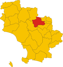
| province | Grosseto (GR) | |
| Coordinates | 42 ° 53 ' N , 11 ° 24' E | |
| height | 324 m slm | |
| surface | 161.66 km² | |
| Residents | 2,457 (Dec 31, 2019) | |
| Population density | 15 inhabitants / km² | |
| Post Code | 58044 | |
| prefix | 0564 | |
| ISTAT number | 053007 | |
| Popular name | Cinigianesi | |
| Patron saint | San Michele (September 29th) | |
| Website | Cinigiano municipality | |
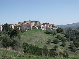
 Panorama of Cinigiano |
||
Cinigiano is a place with 2,457 inhabitants (as of December 31, 2019) in the province of Grosseto , Tuscany region in Italy .
geography
The place extends over around 162 km². It is located about 25 km northeast of Grosseto and about 100 km south of Florence between the Val d'Orcia and the Ombrone valley . It is part of the Montecucco wine region . The place is part of the Comunità montana dell'Amiata grossetano and is in the climatic classification of Italian communities in zone D, 1 972 GG. The place is located on the rivers Ombrone (12 km in the local area), Orcia (4 km in the local area) and Zancona (2 km in the local area).
Its districts include Borgo Santa Rita (102 meters in altitude, approx. 40 inhabitants), Castiglioncello Bandini (606 m, approx. 100 inhabitants), Monticello Amiata (734 m, the largest district with over 400 inhabitants), Poggi del Sasso (349 m , approx. 90 inhabitants), Porrona (254 m, approx. 20 inhabitants) and Sasso d'Ombrone (160 m, approx. 300 inhabitants). The main town itself has about 650 inhabitants.
The neighboring municipalities are Arcidosso , Campagnatico , Castel del Piano , Civitella Paganico and Montalcino ( SI ).
history
Cinigiano was built in the 12th century around the medieval castle (Cassero), of which only remains of walls can be found today. The territory was under the authority of Bernardino di Cinigiano, a vassal of the Aldobrandeschi family . In 1254 she submitted to the rule of Siena . At the end of the 14th century Cinigiano belonged to the domain of the Counts Guidi , who were in power until 1404. Then the Republic of Siena took over again. After the defeat of the Senese Republic in 1555 against the Republic of Florence , the place (like Siena) also fell to the Duchy of Tuscany . In 1766 Leopold II changed the provincial affiliation of the place, which was no longer part of the province of Siena , but was assigned to the province of Grosseto and remained there after the unification of Italy . From 1861 to 1936 the place experienced a population increase from approx. 3500 inhabitants to approx. 5400 inhabitants. After that, the population decreased to around 2650 people in 2011.
Attractions
- Chiesa di San Michele Arcangelo , the first time in 1276 mentioned church in the center. Was substantially expanded in 1598 and restored in 1976. Contains the works Crocifissione con i Dolenti, San Marco Evangelista, San Francesco e un santo guerriero martire by Francesco Vanni (created in 1601) and Madonna con il Bambino (also called Madonna delle Grazie , created in 1693) by Daniele Lunati.
- Chiesa della Madonna delle Nevi , church just outside the historic city walls, which was built in the 13th century. Was restored from 1967 to 1969 and contains frescoes from the 15th century.
- Oratorio della Compagnia di San Sebastiano , church in the town center, which was built at the end of the 16th century. Contains the work Santi Sigismondo martire e Antonio abate che invocano la protezione della Madonna col Bambino e San Giuseppe (17th century, unknown Senese artist).
- Torre dell'Orologio , clock tower in the center of the village, which was built in the 19th century over the demolished Palazzo Civico from the Middle Ages.
- Cappella di Sant'Antonio Abate a Montecucco , chapel built by Bruno Bruni from 1941 to 1943 near the Castello di Monte Cucco.
- Cappella di Santa Marta , chapel built before 1640, which replaced the Pieve di Sant'Ippolito a Martura mentioned in 1188 and took over its function.
- Castello di Porrona (district Porrona), castle from the 13th century, which has always been under the control of Siena and was later inhabited by the Senese families Piccolomini and Tolomei . Guccio di Rinaldo Tolomei was documented here as Podestà in 1298 . In 1377 the fort was badly damaged during attacks by Bretons and Gascon . The palazzo dates from 1504 and was built by Antonio Piccolomini Todeschini .
- Castello di Vicarello , about 10 km west of Cinigiano, which was first mentioned in writing in 1221. Became part of the Republic of Siena in 1438.
- Castiglion del Torto , also called Castiglioncello di Stribugliano , castle in the district of Castiglioncello Bandini. Was built by the Aldobrandeschi , then came into the possession of the Abbazia San Galgano and later belonged to Siena.
- Chiesa di San Donato (Porrona), documented church as early as 1287. Once part of the Abbey of Sant'Antimo . Contains the works San Nicola in trono con angeli e donatori by Giovanni dal Ponte (Giovanni di Marco) and Madonna con il Bambino in trono fra San Donato vescovo e San Rocco by Girolamo di Benvenuto .
- Chiesa del Madonnino , 17th century church just outside Castiglioncello Bandini.
- Chiesa di San Michele Arcangelo (Monticello Amiata), church in the historic center of the district, church from the 13th century, which was significantly changed in the 19th century. Contains the works San Carlo Borromeo in preghiera by Rutilio Manetti (canvas painting, created in 1600) and Madonna col Bambino in trono contornata da angeli ed adorata dai Santi Lorenzo ed Antonio abate by Bartolomeo Neroni (created around 1535).
- Chiesa di San Nicola , church in the historic center of Castiglioncello Bandini. Contains a collection of relics from the 17th and 18th centuries.
- Colle Massari , castle 5 km west of Cinigiano. Was initially owned by the Abbazia San Galgano and later came under the control of Siena.
- Oratorio della Compagnia di San Sebastiano (Monticello Amiata), church just outside the town center from the 16th century. Contains the work Madonna col Bambino in gloria con San Nicola da Tolentino e Sant'Agostino by Domenico Manetti (canvas painting, created around 1650).
- Santuario della Madonna di Val di Prata , santuary just outside Monticello Amiata, was first mentioned in 1218 and rebuilt by Pietro Martinelli from 1847 to 1865. Contains the work Madonna del Carmine, Santa Teresa d'Avila, Santa Teresa d'Ungheria, San Filippo Neri e Sant'Elena by Giuseppe Nicola Nasini .
- Torre di Scudellano , watchtower ruin near the Melacce river approx . 8 km southwest of Cinigiano at 168 m. Was mentioned in writing as early as the 11th century.
literature
- Giuseppe Guerrini / Amministrazione Provinciale di Grosseto: Torri e Castelli della provincia di Grosseto. Nuova Immagine Edizioni, Siena 1999, ISBN 88-7145-154-6 .
- Lucio Niccola / Fiora Bonelli: Paesi dell'Amiata , Cesare Moroni Edizioni, 2003, pp. 115–123.
- Emanuele Repetti: Dizionario Geografico Fisico Storico della Toscana Online edition of the University of Siena on the municipality of Cinigiano
- Felicia Rotundo / Cristina Gnoni Mavarelli: Cinigiano. In: Bruno Santi: Guida Storico-Artistica alla Maremma. Nuova Immagine Edizioni, Siena 1995, ISBN 88-7145-093-0 .
- Touring Club Italiano : Toscana. Milan 2003, ISBN 88-365-2767-1 , p. 842.
Web links
- Official website of the Municipality of Cinigiano
- Website of the Pro Loco in Cinigiano
Individual evidence
- ↑ Statistiche demografiche ISTAT. Monthly population statistics of the Istituto Nazionale di Statistica , as of December 31 of 2019.
- ^ Website of the Unione dei Comuni Montani Amiata Grossetana , accessed on March 21, 2013 (ital.)
- ↑ Website of the Agenzia nazionale per le nuove tecnologie, l'energia e lo sviluppo economico sostenibile (ENEA), accessed on March 21, 2013 (Italian) (PDF file; 322 kB)
- ↑ Official website of the Sistema Informativo Ambientale della Regione Toscana (SIRA) on the rivers in Arcidosso , accessed on March 21, 2013 (ital.)
- ↑ Official website of the ISTAT ( Istituto Nazionale di Statistica ) on the 2001 population figures in the province of Grosseto, accessed on March 21, 2013 (Italian)
- ↑ Roberta Mucciarelli: I Tolomei. Banchieri di Siena. Protagon Editori, Siena 1995, ISBN 88-8024-012-9 , p. 277
- ↑ Michela Becchis on Giovanni dal Ponte in Dizionario Biografico degli Italiani , accessed on March 22, 2013 (Italian)


