
Pitigliano
| Pitigliano | ||
|---|---|---|

|
|
|
| Country | Italy | |
| region | Tuscany | |
| province | Grosseto (GR) | |
| Coordinates | 42 ° 38 ' N , 11 ° 40' E | |
| height | 313 m slm | |
| surface | 102.9 km² | |
| Residents | 3,732 (Dec. 31, 2019) | |
| Population density | 36 inhabitants / km² | |
| Post Code | 58017 | |
| prefix | 0564 | |
| ISTAT number | 053019 | |
| Popular name | Pitiglianesi | |
| Patron saint |
Rochus de Montpellier (August 16) |
|
| Website | Pitigliano | |
 Panorama of Pitigliano |
||

Pitigliano is an Italian municipality with 3732 inhabitants (as of December 31, 2019) in the southeast of the province of Grosseto in Tuscany , between steep valleys with a medieval town center.
The municipality is a member of the association I borghi più belli d'Italia (The Most Beautiful Places in Italy).
geography
The tufa in this area is due to the volcanic past of this part of Tuscany. About 20 km from Pitigliano is Lake Bolsena , a caldera about 14 km in diameter. It is the result of enormous volcanic explosions that occurred about 300,000 years ago. The Monte Amiata , a 1738 m high extinct volcano, can be seen from Pitigliano, in winter it is a popular ski area. Pitigliano itself lies on the Lente and Meleta rivers.
The only district (Frazione) is Casone (524 m, approx. 130 inhabitants).
The neighboring municipalities include Farnese ( VT ), Ischia di Castro (VT), Latera (VT), Manciano , Sorano and Valentano (VT).
history
The city is located in the original Etruscan ancestral land and is built on a 300 m high tufa rock. The tuff is also the usual building material here, cut from the rock in brick form. Pitigliano is surrounded by the deep gorges of the Lente and Meleta streams, which over time have cut into the plateau. In addition to the natural canyons, there are many so-called "Vie Cave", a system of paths used by the Etruscans that were dug into the tufa around the city. Some of these Etruscan roads are provided with sophisticated drainage systems.
The first written mention of the city comes from the year 1061. In the early 13th century the city belonged to the Aldobrandeschi family and became the main town in the area. In 1293 it went to the Orsini , at the beginning of the 17th century to the Medici , who incorporated it into the Grand Duchy of Tuscany in 1604 . During the Risorgimento in the 19th century, it became part of the Kingdom of Italy .
The history of the city is more strongly influenced than in other parts of the Maremma by Jews who found refuge from persecution and displacement in Pitigliano in the 16th century. An association looks after the city's Jewish heritage, so that the synagogue and the Jewish quarter of a Sephardic congregation (“Little Jerusalem”, Piccola Gerusalemme ) in the old town that have existed since 1500 can now be visited again.
See also: Jewish cemetery (Pitigliano)
Population development


Attractions

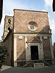
- The cathedral "Santi Pietro e Paolo" goes back to the Middle Ages. In the 16th century and afterwards it was changed a lot and now has a late baroque facade. Contains two works by Pietro Aldi . The Campanile , at heart, a converted medieval church tower to gender tower , surmounted visible from the city.
- The church of San Rocco is the oldest church in the city and was mentioned in a document as early as 1274. On the outer north wall there is a stone relief from the 12th century.
- The Palazzo Orsini was built as a defensive fortification at the only natural entrance to the city and was expanded again and again over several centuries. Today the bishopric, a museum of religious art and the city archaeological museum are located in the castle.
- The impressive aqueduct was started in the mid-16th century but was not completed until the 17th century under the Medici .
- In the area of the former Jewish quarter, the synagogue , as well as the remains of a mikveh , a kosher slaughterhouse and bakery can be visited.
- Around Pitigliano there are a large number of Etruscan tombs, the most famous of which is the "Tomba Ildebranda". It is wrongly named after the famous Ildebrando von Sovana , who went down in church history in the 11th century as Pope Gregory VII . The excavation site is open to the public.
- Another significant testimony to the Etruscan culture in the area around the city are the remains of the “Poggio Buco” settlement between Pitigliano and Manciano , where there is also a museum devoted to the history of the area.
The Church of San Rocco
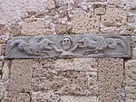
Relief on the Chiesa S. Maria e S. Rocco
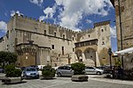
Orsini Palace

Exhibits in the Museo civico archeologico

Aqueduct (left in the picture) and synthesis of tuff and houses
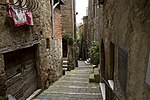
Alley in the old town

"Little Jerusalem" at night


.jpg)

Personalities
- Francesco Zuccarelli (born August 15, 1702 in Pitigliano, † December 30, 1788 in Florence ), Rococo painter
- Johann Karl Müllener (born March 3, 1768 in Lausanne (baptism), † May 23, 1832 in Pitigliano), landscape painter active in Seravezza and Florence
literature
- Emanuele Repetti: PITIGLIANO (Pitilianum) nella Val di Fiora. In Dizionario Geografico Fisico Storico della Toscana (1833–1846), online edition of the University of Siena (pdf, ital.)
- Touring Club Italiano : Toscana. Milan 2003, ISBN 88-365-2767-1 , p. 890 ff.
Web links
|
Further content in the sister projects of Wikipedia:
|
||
|
|
Commons | - multimedia content |
|
|
Wikivoyage | - Travel Guide |
Individual evidence
- ↑ Statistiche demografiche ISTAT. Monthly population statistics of the Istituto Nazionale di Statistica , as of December 31 of 2019.
- ^ I borghi più belli d'Italia. Borghipiubelliditalia.it, accessed August 6, 2017 (Italian).
- ↑ Official website of ISTAT ( Istituto Nazionale di Statistica ) on 2001 population figures in the province of Grosseto, accessed on October 30, 2014 (Italian)
- ↑ Wolfgang Geier to Gundolf Keil . In: Medical historical messages. Journal for the history of science and specialist prose research. Volume 35, 2016 (2018), p. 301 f. ( Correspondence dated November 9, 2015), here: p. 302.
- ↑ Johann Karl Müllener. In: Sikart , accessed January 23, 2016.

Arcidosso | Campagnatico | Capalbio | Castel del Piano | Castell'Azzara | Castiglione della Pescaia | Cinigiano | Civitella Paganico | Follonica | Gavorrano | Grosseto | Isola del Giglio | Magliano in Toscana | Manciano | Massa Marittima | Monte Argentario | Monterotondo Marittimo | Montieri | Orbetello | Pitigliano | Roccalbegna | Roccastrada | Santa Fiora | Scansano | Scarlino | Seggiano | Semproniano | Sorano