
Sorano
| Sorano | ||
|---|---|---|

|
|
|
| Country | Italy | |
| region | Tuscany | |
| province | Grosseto (GR) | |
| Coordinates | 42 ° 41 ' N , 11 ° 43' E | |
| height | 379 m slm | |
| surface | 174.60 km² | |
| Residents | 3,180 (Dec 31, 2019) | |
| Population density | 18 inhabitants / km² | |
| Post Code | 58010 | |
| prefix | 0564 | |
| ISTAT number | 053026 | |
| Popular name | Soranesi | |
| Patron saint |
Saint Nicholas (December 6th) |
|
| Website | Sorano | |
 Panorama of Sorano |
||

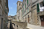
Sorano is a small medieval town with 3180 inhabitants (as of December 31, 2019) in the Italian province of Grosseto in Tuscany .
Geographical location

The city is located in southern Tuscany, in the far east of the High Maremma , on the slope of a tuff hill above the Lente river , which is fed by the smaller watercourses Cercone and Castelsereno . Like Pitigliano and Castell'Azzara , it is one of the tuff cities ( città del tufo ).
The following settlements belong to the municipality: Castell'Ottieri, Cerreto, Elmo , Montebuono, Montevitozzo, Montorio, San Giovanni delle Contee, San Quirico, San Valentino and Sovana .
Neighboring municipalities are Acquapendente ( VT ), Castell'Azzara , Latera (VT), Manciano , Onano (VT), Pitigliano , Proceno (VT) and Semproniano . To the east, Sorano borders the Lazio region . The distance to the provincial capital Grosseto is about 80 km. After Rome is 150 km, Siena is about 100 km, Florence about 180 km away.
history
The rock plateau of Sorano was probably inhabited since the Bronze Age. At the time of the Etruscans , the area was definitely settled, but the Etruscan name of the settlement has not been passed down. The current place name is probably derived from the Latin name of an Etruscan deity, Father Soranus . Sorano was administered by the Municipium of Sovana in Roman times .
In the Middle Ages, the city was under Lombard rule in the eighth century . In 862 it became the property of the Counts Aldobrandeschi . These were replaced as rulers by the Orsini family in 1312 , who in turn had to cede the city to the Medici in 1604 . In 1737 the city came under the rule of the House of Habsburg-Lothringen .
The erosion of the tuff rock, which affected the building fabric of the city, led to the city's gradual decline. In recent years Sorano has been upgraded as a tourist destination.
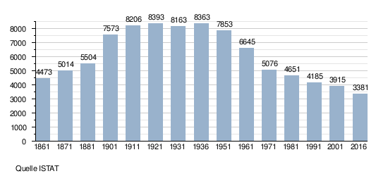
Population development
Attractions
- The church Collegiata di San Niccolò was mentioned as early as 1276.
- The place has two medieval fortifications, the Fortezza Orsini and the Masso Leopoldino .
- The to Fortezza Orsini belonging Orsinipark only get even partially, some sculptures and the remains of a well are still visible.
- The Palazzo Comitale is a well-preserved Renaissance palace that served as the residence of the Orsini .
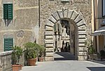
- The Porta dei Merli is a city gate that used to have a drawbridge and is decorated with coats of arms.
- Outside the city there are a number of caves that were used by the Etruscans and Romans . The most famous of these is the necropolis of San Rocco .
- Also outside the city are several Vie Cave , a system of paths used by the Etruscans that were dug into the tuff.
Old town view to the Collegiata di San Niccolò

City view with Fortezza Orsini

Fortezza Orsini

Orsini coat of arms on the fortress

Palazzo Orsini or Palazzo Comitale

City view with Masso Leopoldino

Porta dei Merli
City gate Porta di Sopra


Personalities
- Hildebrand von Soana from the Aldobrandeschi family , who later became Pope Gregory VII, was born around 1020 in the village of Sovana , which belongs to Sorano . He played an important role in the investiture controversy ( walk to Canossa ).
- Angelo Comastri , Curia Cardinal of the Roman Catholic Church, was born in Sorano in 1943.
literature
- Emanuele Repetti: SORANO nella Val di Fiora. In: Dizionario Geografico Fisico Storico della Toscana (1833–1846), online edition of the University of Siena (PDF 13.5 kB, Italian)
Web links
Individual evidence
- ↑ Statistiche demografiche ISTAT. Monthly population statistics of the Istituto Nazionale di Statistica , as of December 31 of 2019.
- ^ Statuto comunale of Sorano, Art. 4 (PDF; 189 kB)
- ^ Giovanni Feo: The tuff cities in the Fioratal . 3. Edition. Editrice Laurum, Pitigliano 2013, p. 49-50 .

Arcidosso | Campagnatico | Capalbio | Castel del Piano | Castell'Azzara | Castiglione della Pescaia | Cinigiano | Civitella Paganico | Follonica | Gavorrano | Grosseto | Isola del Giglio | Magliano in Toscana | Manciano | Massa Marittima | Monte Argentario | Monterotondo Marittimo | Montieri | Orbetello | Pitigliano | Roccalbegna | Roccastrada | Santa Fiora | Scansano | Scarlino | Seggiano | Semproniano | Sorano