Massa Marittima
| Massa Marittima | ||
|---|---|---|

|
|
|
| Country | Italy | |
| region | Tuscany | |
| province | Grosseto (GR) | |
| Coordinates | 43 ° 3 ' N , 10 ° 54' E | |
| height | 380 m slm | |
| surface | 283.73 km² | |
| Residents | 8,297 (Dec 31, 2019) | |
| Population density | 29 inhabitants / km² | |
| Factions | Prata, Tatti, Niccioleta, Valpiana | |
| Post Code | 58024 | |
| prefix | 0566 | |
| ISTAT number | 053015 | |
| Popular name | Massetani | |
| Patron saint |
St. Cerbonius (October 10) |
|
| Website | Massa Marittima | |
 Massa Marittima |
||
Massa Marittima is a town with 8,297 inhabitants (as of December 31, 2019) in Tuscany in Italy .
geography
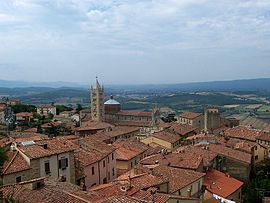
The medieval town is located 380 m above sea level on a hill above the Maremma plain in the Colline Metallifere and in the climatic classification of Italian communities in zone E, 2 129 GG. The municipality is located about 85 km southwest of the regional capital Florence , 37 km northwest of the provincial capital Grosseto and 46 km southwest of Siena .
The river Bruna has its source in the south of the municipality and the river Pecora in the west . Other important bodies of water in the municipality are the Torrenti Carsia (10 of 17 km in the municipality), Ritorto (16 of 19 km in the municipality) and Zanca (12 of 15 km in the municipality).
In addition to the core town ( capoluogo ), the municipality includes the districts (frazioni) Ghirlanda (274 m above sea level, approx. 170 inhabitants), Niccioleta (460 m, approx. 250 inhabitants), Prata (620 m, approx. 560 inhabitants), Tatti (412 m, approx. 230 inhabitants) and Valpiana (145 m, approx. 450 inhabitants).
Neighboring municipalities are Follonica , Gavorrano , Massa Marittima , Montieri , Roccastrada and Scarlino and the the province of Livorno associated Suvereto .
history
The area around Massa Marittima - although not verifiably the hill itself - was inhabited as early as Etruscan and Roman times. The mineral resources of the Colline Metallifere (copper, silver, iron ore) extending to the north were already mined in ancient times .
The name possibly goes back to the ancient estate of Massa Veternensis , the exact location of which can no longer be traced. The epithet Marittima , which Massa only received in the Middle Ages, does not mean that the city was located on the coast, but rather identifies the place as belonging to the Maremma , the marshland formerly connected to the Tyrrhenian Sea , which was called Maritima Regio in Roman times .
The city owes its foundation and rise to the transfer of the episcopal see from Populonia in the 9th century. Greek pirates had destroyed Populonia, and the bishop fled to this hill with the bones of Saint Cerbonius .
Against the resistance of the feudal lords of the Aldobrandeschi family and the bishops of Roselle (Tuscany) , Massa declared itself an autonomous republic in 1225. The city was able to maintain its independence for more than a century. She lived mainly from mining and issued the first mining code in the world. The use of the compass, whose use as a guide in the mines of Massa is documented as early as the 13th and 14th centuries, was also groundbreaking. In 1335 the city was conquered by Siena and from then on shared the fate of this republic: 1555 conquest by Florence , 1569 incorporation into the Grand Duchy of Tuscany , which from 1737 belonged to the domain of the Habsburgs and became part of the Italian national state in 1860.
With around 10,000 inhabitants, Massa Marittima was an independent city-state and an important economic center. Malaria , which spread from the surrounding swamps, decimated the population to around 500 by the 16th century. Only the recultivation and drainage program of the Maremma ( la bonifica ), initiated by the Habsburg grand dukes of Tuscany in the 18th and 19th centuries, brought about a turning point. The disused mines were revitalized around 1830 and the population increased again. In 2000, Massa Marittima had roughly the same number of inhabitants as in the times around 1300.
Mining was the city's main source of income until the 1970s. Today the unprofitable mines are closed, a tunnel was converted into a museum in 1980 and tourism is the main economic factor today.
The city is a member of Cittàslow , a movement founded in Italy in 1999 to slow down and improve the quality of life in cities.
Demographic development

Attractions
The city of Massa Marittima is divided into three districts: The Città Vecchia (= historic old town), the Borgo (originally the quarter of the craftsmen) and the Città Nuova (= new town), which mainly consists of the residential areas of the former miners.
Città Vecchia
The heart of the lower town is the Piazza Garibaldi with:
- San Cerbone Cathedral
- Palazzo del Podestà (13th century, now the Archaeological Museum )
- Palazzo Comunale (begun around 1250, modified several times); The oldest part is the Torre del Bargello prison tower , neighboring buildings were built and integrated later
- Palazzo dei Conti di Biserno, until the 17th century bishop's palace, before the bishops moved into a new building next to the cathedral
- Loggia del Comune from the 14th century (renewed and extended by an upper floor in the 19th century)
- Palazzo Bandini
- Palazzo Pannocchieschi
From this central, triangular square, the promenade of Corso della Libertà starts with numerous, sometimes heavily modified, medieval aristocratic palaces, today home to shops, cafes and restaurants. The birth house of the Franciscan Bernardine of Siena is also on this street .
Città Nuova
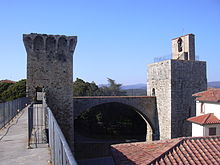
After conquering the city-state in 1335, the Sienese fortified Massa Marittima. The massive square defense tower ( Torre del Candeliere ), which already existed under the Massetans , was connected to the new bastions by a 22 m Gothic arch (the so-called Arco Senese ).
The fortress - if not under the Habsburgs in the 18th and 19th centuries. Demolished in the 19th century - is accessible; the tower can be climbed and offers a wide view of the city.
Incidentally, there are still three gates of the Sienese city fortifications:
- In the north the Porta San Rocco,
- in the south the Porta al Salnitro as well
- to the east the Porta alle Sicili.
Other sights of the Upper Town:
- Piazza Matteotti with the former arsenal (Palazzetto degli Armi, 14th century, now a museum for the history of mining)
- Oil mill museum ( Antico Frantoio ) with olive press from the 18th century.
- Mine museum in a 700 m long gallery, with tools and mineral collection
- Augustinian Church, a hall church started in 1273 with a polygonal apse designed by Domenico di Agostino , a cloister from the 15th century and a campanile from 1627; adjoining it is the only partially preserved Romanesque prayer house of San Pietro all'Orto with the remains of Sienese frescoes from the life of St. Nicholas of Tolentino
- Franciscan church outside the city walls, dating from the 13th century, heavily modified
Borgo
Borgo was originally the craftsmen's quarter.
- Casa Fedi, tower house, dating from the 14th century
- Casa Billi, tower house, dating from the 13th century
- Palazzina della Zecca, site of the old mint
Crossbow shooting competition
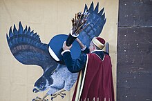
Twice a year, on the fourth Sunday in May in honor of St. Bernardine of Siena and on the second Sunday in August on or after the Assumption of Mary , the historical Balestro del Girifalco crossbow takes place. It is a competition between the three historical districts (Terzieri) - an idea that is also the basis of the Palio di Siena , but cannot be compared in terms of its execution.
The festival opens with a procession of 150 people in historical costumes and a flag throwing demonstration (Sbandonieri) . The core ceremony consists in the fact that 24 crossbowmen (8 each from the districts of Cittàvecchia, Cittànuova and Borgo) have to aim from a distance of 36 m at the heart of an artificial falcon, a piece of wood 12 cm in diameter; the falcon symbolizes the enemy. The district whose shooters get the most hits or best approaches wins.
sons and daughters of the town
- Constantius Gallus (325 / 326–354), Roman emperor
- Bernardine of Siena (1380–1444), saint
- Umberto Lenzi (1931–2017), film director and author
- Luciano Tovoli (* 1936), cameraman
literature
- Emanuele Repetti: MASSA MARITTIMA, MASSA DI MAREMMA, e talvolta anche MASSA VETERNENSE, MASSA METALLIFERA nella Maremma toscana. In Dizionario Geografico Fisico Storico della Toscana (1833–1846), online edition of the University of Siena (pdf, Italian).
- Pietro Torriti: Massa Marittima, Firenze 2003
- Touring Club Italiano : Toscana , Milan 2003, ISBN 88-365-2767-1 , pp. 834-840.
- Klaus Zimmermanns: Toscana, Dumont-Kunstreisführer, 5th edition, Cologne 2004
Web links
- Official website of the city
- Parco nazionale delle Colline Metallifere grossetane
- Francesco Galgani: History, Mining, Territory, Photographs, Lithographs and Drawings , on massamarittima-toscana.net, accessed June 19, 2020
Individual evidence
- ↑ Statistiche demografiche ISTAT. Monthly population statistics of the Istituto Nazionale di Statistica , as of December 31 of 2019.
- ↑ Website of the Agenzia nazionale per le nuove tecnologie, l'energia e lo sviluppo economico sostenibile (ENEA), accessed on December 5, 2013 (Italian) (PDF; 330 kB)
- ↑ Official website of the Sistema Informativo Ambientale della Regione Toscana (SIRA) on the rivers in Massa Marittima , accessed on December 5, 2013 (ital.)
- ↑ Official website of the ISTAT ( Istituto Nazionale di Statistica ) on the 2001 population figures in the province of Grosseto, accessed on December 5, 2013 (Italian)
- ^ Karl-Heinz Ludwig, Volker Schmidtchen: Propylaea history of technology. Metals and Power 1000–1600 , Berlin 1997, pp. 62–64 ISBN 3-549-05633-8


