Colline Metallifere

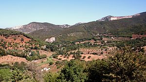
The Colline Metallifere [ kol-ˈli: nə metal-ˈli: ferə ], the Tuscan Ore Mountains (Italian: "Metallhaltige Hügel", in German Pars-pro-toto translation also called Erzhügel ) are a mountain range of central and southern Tuscany . They have been known for their natural resources since ancient times; today moderate tourism is developing.
location
The geographical location of the range of hills can be interpreted narrower or wider. Some maps limit it to a core region north of the former mining center Massa Marittima with the tunnels near Montieri and Gerfalco , southeast of Cecina on the Tyrrhenian Sea and southwest of Siena .
Occasionally the hills south of Massa Marittima to Grosseto , in which minerals were also mined, are included in the term and referred to as Colline Metallifere Grossetane . The center of this southern extension is Gavorrano .
The Cecina valley , also known as the Devil's Valley because of its geothermal activities , is also sometimes included in literature. In this area bordering the Alabaster Hills of Volterra in the north , ENEL operates one of the world's largest geothermal power plants for generating electricity near Larderello .
History / economic use

According to Roman sources, the Etruscans mined iron ore, copper and silver in the hills; immediately south of Volterra it was about alabaster . In the Middle Ages, ore mining flourished, especially in the Free City Republic of Massa Marittima, which set up the world's first mining code in 1225.
The uncontrolled swamping of the Maremma , which brought malaria to Massa Marittima and decimated the local population from 10,000 to only approx. 500, brought mining to a standstill in the later Middle Ages. Only after a successful recultivation and drainage program by the Habsburg Grand Dukes of Tuscany was it possible to resume activities in the mines of Massa, Gavorrano and Montieri in the 19th century. Mining again became the region's main source of income until the 1970s. They then closed again due to a lack of profitability, as the import of raw materials from Africa, South America and Central Asia had become cheaper.
The Colline Metallifere today
In the last quarter of the 20th and the beginning of the 21st century, tourism replaced mining as an economic basis. At the time of mining, there was little interest shown in the natural landscape and fauna of the region, which was therefore able to develop away from the mines without human intervention. Large, closed oak and chestnut forests cover the higher mountain areas, a landscape that is rare in central Italy. Macchia , holm oak and gorse predominate in the lower elevations . Wild boar , porcupine , badger and stone marten live in the forests .
Individual hikers and riders gradually discover the area in the valley of the upper Cecina and the river Merse west of Siena as part of an agritourism or holiday on equestrian farms .
By decree of the Italian Ministry of the Environment of February 28, 2002, the municipal areas of Follonica , Gavorrano , Massa Marittima , Monterotondo Marittimo , Montieri , Roccastrada and Scarlino were institutionalized as Parco Tecnologico ed archeologico delle Colline Metallifere . The aim of the national park is to document the past of the region as an important mining center of supraregional importance for posterity. Abandoned tunnels and abandoned quarries are explained through information boards throughout the mountain range. A completely preserved pyrite mine, which has been expanded as a museum, has been accessible with a guided tour in the Parco Minerario Naturalistico di Gavorrano , a core part of the park, since 2003 .
literature
- Hella Kothmann / Wolf-Eckart Bühler : Reise Know-how Toscana, 4th edition Bielefeld 2005, p. 282 ff.
Web links
- Le “Colline Metallifere” , natural and geological description of the region with a map of the core region (Italian)
- The Colline Metallifere. The valleys of the Farma and the Merse , Tuscany hiking
- Website of the Parco Tecnologico ed archeologico delle Colline Metallifere (partly in Italian)
Coordinates: 43 ° 14 ' N , 10 ° 51' E
