
Merse
| Merse | ||
 The Merse near San Galgano |
||
| Data | ||
| location | Tuscany ( Province of Siena , Province of Grosseto ), Italy | |
| River system | Ombrone | |
| Drain over | Ombrone → Tyrrhenian Sea | |
| River basin district | Appennino Settentrionale | |
| source | Poggio Croce di Prata and Poggio di Montieri in the Colline Metallifere range of hills | |
| Source height | 848 m slm | |
| muzzle | near Pian di Rocca (district of Monticiano ) in the Ombrone coordinates: 43 ° 4 ′ 34 " N , 11 ° 21 ′ 59" E, 43 ° 4 ′ 34 " N , 11 ° 21 ′ 59" E |
|
| Mouth height | approx. 107 m slm | |
| Height difference | approx. 741 m | |
| Bottom slope | approx. 11 ‰ | |
| length | 68 km | |
| Left tributaries | Feccia , Rosia , Serpenna | |
| Right tributaries | Farma | |
| Communities | Montieri , Chiusdino (districts Ciciano, Palazzetto), Monticiano (districts Pian di Rocca, San Lorenzo a Merse), Sovicille (district Brenna) | |
The Merse is a 68 km long river in the Tuscany region of Italy, which crosses the provinces of Siena and Grosseto from north to south and flows into the Ombrone at Pian di Rocca (district of Monticiano ) as a right tributary .
course
The river has its source in the Poggio Croce di Prata and Poggio di Montieri hills south of Montieri in the Colline Metallifere range of hills at an altitude of 848 m and spends 8 km in the municipality. It flows past the old mines of Montieri, called Le Roste because of their oxidizing iron minerals and copper residues , and turns first northeast towards Chiusdino (18 km in the municipality). He passes the district of Ciciano , southwest of Chiusdino, and then the district of Palazzetto , to the southeast . It then flows north past the Abbazia San Galgano , which it served as the main source of water in the Middle Ages, where after a few kilometers the Fèccia river joins the Bivio del Madonnino as a left tributary . From there the river runs a few kilometers to the east, then to the north, where it flows around the districts of Sovicille (18 km in the municipality) Brenna and Orgia . Here the river turns to the south, where it passes at San Lorenzo a Merse , a district of Monticiano (14 km in the municipality) and undercuts the Strada Statale 223 di Paganico . From there to the mouth it serves Murlo as a western border (7 km). A few meters afterwards, he passes the Ponte a Macereto bridge (also called Ponte a Maciareto ), which was built in 1368 and used until 1827, and which today can only be viewed as a ruined bridge. The bridge was rebuilt in 1487 under the direction of Francesco di Giorgio Martini after it collapsed in large parts due to floods in the spring of 1485. After the construction of the new bridge for the Regia Strada Grossetana in 1827, it was no longer used and suffered damage in the Second World War . The current situation was created by the floods of 1962. Behind the district of Bagni di Petriolo , the Merse meets its right tributary, Farma . A few kilometers further on, it flows into the Ombrone in the Pian di Rocca district , of which it is the right tributary.
Val di Merse
The Mersetal (Val di Merse) is located in the southeast of the province of Siena and includes the municipalities of Chiusdino, Monticiano, Murlo and Sovicille, which have come together to form the Comunità montana Val di Merse .
Nature parks
The nature parks Riserva naturale Alto Merse and Riserva naturale Basso Merse , both of which were created in 1996, are located on the Merse . The former covers approx. 2000 hectares , the latter approx. 1743, both of which are in the province of Siena, the Basso Merse Nature Park also in the province of Grosseto (1,478 hectares in the province of Siena, 265 hectares in the province of Grosseto).
photos

The Merse at Montieri near the mines of Le Roste (Montieri)

Bridge ruin Ponte a Macereto near San Lorenzo a Merse (Monticiano / Murlo)
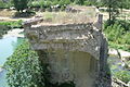
Bridge ruin Ponte a Macereto near San Lorenzo a Merse (Monticiano / Murlo)

The Merse near Orgia (Sovicille)


literature
- Giorgio Battini: Il fiume racconta. Viaggio nella Toscana dei fiumi. Casa Editrice Bonechi, Florence 1993, ISBN 88-7009-941-5 , p. 231 f.
- Emanuele Repetti: Dizionario Geografico Fisico Storico della Toscana. Online edition of the University of Siena on the Merse River
Web links
- Official website of the Sistema Informativo Ambientale della Regione Toscana (SIRA) on the Merse
- Official website of the Province of Siena on the Natural Parks
Individual evidence
- ↑ a b c d e f Sistema Informativo Ambientale della Regione Toscana (SIRA)
- ↑ Emanuele Repetti
- ↑ Giorgio Battini
- ↑ Repetti to the Ponte a Macereto bridge ( Memento of the original from 23 September 2015 in the Internet Archive ) Info: The archive link has been inserted automatically and has not yet been checked. Please check the original and archive link according to the instructions and then remove this notice.
- ↑ Ponte a Macereto on the Ecomuseo della Val di Merse website, accessed on December 7, 2014 (Italian)
- ↑ Riserva naturale Alto Merse on the Ecomuseo della Val di Merse website, accessed on December 7, 2014 (Italian)
- ↑ Riserva naturale Basso Merse on the pages of Ecomuseo della Val di Merse, accessed on December 7, 2014 (Italian)