Autostrada A90
| Autostrada A90 in Italy | |||||||||||||||||||||||||||||||||||||||||||||||||||||||||||||||||||||||||||||||||||||||||||||||||||||||||||||||||||||||||||||||||||||||||||||||||||||||||||||||||||||||||||||||||||||||||||||||||||||||||||||
| Grande Raccordo Anulare | |||||||||||||||||||||||||||||||||||||||||||||||||||||||||||||||||||||||||||||||||||||||||||||||||||||||||||||||||||||||||||||||||||||||||||||||||||||||||||||||||||||||||||||||||||||||||||||||||||||||||||||

|
|||||||||||||||||||||||||||||||||||||||||||||||||||||||||||||||||||||||||||||||||||||||||||||||||||||||||||||||||||||||||||||||||||||||||||||||||||||||||||||||||||||||||||||||||||||||||||||||||||||||||||||
| |
|||||||||||||||||||||||||||||||||||||||||||||||||||||||||||||||||||||||||||||||||||||||||||||||||||||||||||||||||||||||||||||||||||||||||||||||||||||||||||||||||||||||||||||||||||||||||||||||||||||||||||||
| map | |||||||||||||||||||||||||||||||||||||||||||||||||||||||||||||||||||||||||||||||||||||||||||||||||||||||||||||||||||||||||||||||||||||||||||||||||||||||||||||||||||||||||||||||||||||||||||||||||||||||||||||
| Basic data | |||||||||||||||||||||||||||||||||||||||||||||||||||||||||||||||||||||||||||||||||||||||||||||||||||||||||||||||||||||||||||||||||||||||||||||||||||||||||||||||||||||||||||||||||||||||||||||||||||||||||||||
| Operator: | |||||||||||||||||||||||||||||||||||||||||||||||||||||||||||||||||||||||||||||||||||||||||||||||||||||||||||||||||||||||||||||||||||||||||||||||||||||||||||||||||||||||||||||||||||||||||||||||||||||||||||||
| Start of the street: | Since this is a continuous ring road, the start of the road (km 0) is conventionally placed at the junction with the SS 1 Aurelia (junction 1) and the digits are increased clockwise ( 41 ° 53 ′ N , 12 ° 23 ′ E ) |
||||||||||||||||||||||||||||||||||||||||||||||||||||||||||||||||||||||||||||||||||||||||||||||||||||||||||||||||||||||||||||||||||||||||||||||||||||||||||||||||||||||||||||||||||||||||||||||||||||||||||||
| Overall length: | 68.2 km | ||||||||||||||||||||||||||||||||||||||||||||||||||||||||||||||||||||||||||||||||||||||||||||||||||||||||||||||||||||||||||||||||||||||||||||||||||||||||||||||||||||||||||||||||||||||||||||||||||||||||||||
|
Regions : |
|||||||||||||||||||||||||||||||||||||||||||||||||||||||||||||||||||||||||||||||||||||||||||||||||||||||||||||||||||||||||||||||||||||||||||||||||||||||||||||||||||||||||||||||||||||||||||||||||||||||||||||
| Requirement for use: | toll-free | ||||||||||||||||||||||||||||||||||||||||||||||||||||||||||||||||||||||||||||||||||||||||||||||||||||||||||||||||||||||||||||||||||||||||||||||||||||||||||||||||||||||||||||||||||||||||||||||||||||||||||||
| Development condition: | 2 × 3 lanes | ||||||||||||||||||||||||||||||||||||||||||||||||||||||||||||||||||||||||||||||||||||||||||||||||||||||||||||||||||||||||||||||||||||||||||||||||||||||||||||||||||||||||||||||||||||||||||||||||||||||||||||
| The GRA at junction 21–22 | |||||||||||||||||||||||||||||||||||||||||||||||||||||||||||||||||||||||||||||||||||||||||||||||||||||||||||||||||||||||||||||||||||||||||||||||||||||||||||||||||||||||||||||||||||||||||||||||||||||||||||||
|
Course of the road
|
|||||||||||||||||||||||||||||||||||||||||||||||||||||||||||||||||||||||||||||||||||||||||||||||||||||||||||||||||||||||||||||||||||||||||||||||||||||||||||||||||||||||||||||||||||||||||||||||||||||||||||||
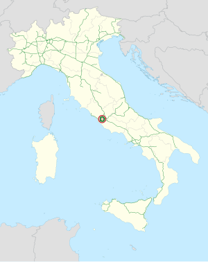
The Autostrada A90 ( Italian for 'Motorway A90'), also called Autostrada del Grande Raccordo Anulare (short: GRA , Italian for 'Great motorway ring connection'), is a 68.2 km long Italian ring motorway that goes around the capital Rome shows around. It is toll-free along its entire length . The autobahn has been officially designated as “A90” since 1999, but this has not yet been implemented in practice, as the signs still only have the abbreviation “GRA”.
The acronym “GRA” ( large ring connection ) is also a tribute to the engineer Eugenio Gra, the ANAS president at the time of the planning of the ring road. He was one of the main planners and supporters of this construction project.
history
First plans
Towards the end of the Second World War , the proposal arose to build a ring-shaped road around Rome. One of the main goals of the planners was to build the street as evenly as possible away from the geographical city center , the Capitol . A distance of seven miles (about 11.4 km) was chosen . Initially, the road was built with the intention of keeping out of the city traffic non-central Rome traffic . It was only later that it gained the additional importance of connecting different roads in the shortest and most efficient way possible (for example the A1 with the then A2 ).
The construction
Work began in the late 1940s. The first section ( Flaminia - Tiburtina ) was completed in 1952. Until 1970, the road was expanded in sections until the ring was closed with the Aurelia -Flaminia section .
Although the GRA was originally designed and built as a two-lane road, it quickly became clear to those responsible that the traffic density was far higher than initially assumed. As a result, the road was expanded to two lanes in each direction by the end of the 1950s . When in 1979 there were also hard shoulders along the entire length , the ring road was finally upgraded to a motorway .
In 1983 work began on widening it again to three lanes in each direction. Today the entire GRA has been expanded to six lanes (three lanes in each direction).
Introduction of a toll
Due to the high volume of traffic and the associated high stress on the roadway , the introduction of a toll , as it already exists on most Italian motorways , has recently been discussed. However, there are numerous factors that make an introduction virtually impossible:
- The toll booths would exacerbate the already critical traffic situation.
- Sufficient space must be created for the toll booths, especially at the respective exits , which are very close together.
- There is strong resistance among the Roman population to such a proposal.
Trivia
- The only common name among the inhabitants of Rome is Il Raccordo (English: the feeder ). The full name is only used in official documents.
- Many road maps do not use a common name for the A90. Instead, one often finds the terms “northern bypass”, “eastern bypass”, “southern bypass” and “western bypass”.
- Despite the recent introduction of numbering the exits, it is customary among Roman citizens to name the exits after the streets they cross. In addition, there are numerous inconsistencies in the numbering sequence, as new connection points have always been added that have not yet been assigned a number.
- The Romans also often regard the motorway ring as the city limit , similar to how the Parisians consider their boulevard périphérique . Everything that is outside the ring is therefore not assigned to the city of Rome.
- In Fellini's Roma (1972) by Federico Fellini , a gigantic traffic jam is staged on the GRA.
- The Italian Gianfranco Rosi released The Other Rome (Sacro GRA), an award-winning documentary film in 2013 , which is dedicated to people who live on and with the GRA.
Web links
Individual evidence
- ^ Structures along the GRA
- ^ Film profile ( memento from September 9, 2013 in the Internet Archive ) at labiennale.org (English; accessed on September 8, 2013).


