Argens
| Argens | ||
|
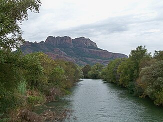
The river with the "Rocher de Roquebrune" |
||
| Data | ||
| Water code | FR : Y5-0200 | |
| location | France , Provence-Alpes-Cote d'Azur region | |
| River system | Argens | |
| source | in the municipality of Seillons-Source-d'Argens, 43 ° 30 ′ 14 ″ N , 5 ° 54 ′ 26 ″ E |
|
| Source height | approx. 283 m | |
| muzzle | in the municipality of Fréjus in the Mediterranean Coordinates: 43 ° 24 ′ 30 ″ N , 6 ° 44 ′ 9 ″ E, 43 ° 24 ′ 30 ″ N , 6 ° 44 ′ 9 ″ E |
|
| Mouth height | approx. 0 m | |
| Height difference | approx. 283 m | |
| Bottom slope | approx. 2.4 ‰ | |
| length | 116 km | |
| Discharge at the Roquebrune-sur-Argens A Eo gauge : 2530 km² |
MQ Mq |
19 m³ / s 7.5 l / (s km²) |
| Medium-sized cities | Fréjus | |
| Small towns | Vidauban , Les Arcs , Le Muy , Roquebrune-sur-Argens | |
The Argens is a coastal river in southeast France that runs in the Var department in the Provence-Alpes-Côte d'Azur region . It rises in the municipality of Seillons-Source-d'Argens , generally drains east to southeast and flows into the Mediterranean after 116 kilometers in the municipality of Fréjus .
Places on the river
(Order in flow direction)
- Châteauvert
- Correns
- Montfort-sur-Argens
- Carcès
- Le Thoronet
- Vidauban
- Les Arcs
- Le Muy
- Roquebrune-sur-Argens
- Fréjus
Tributaries
(Order in flow direction)
|
Left tributaries: |
Right tributaries: |
See also
- List of French Mediterranean tributaries and their tributaries, from 36 km in length, sorted geographically
Web links
Commons : Argens - collection of images, videos and audio files
- Maximilian Ihm : Argenteus . In: Paulys Realencyclopadie der classischen Antiquity Science (RE). Volume II, 1, Stuttgart 1895, Col. 712 f.
Individual evidence
- ↑ Source geoportail.gouv.fr
- ↑ estuary geoportail.gouv.fr
- ↑ Water information system Service d'Administration National des Données et Référentiels sur l'Eau (French) ( information ), accessed on February 23, 2014, rounded to full kilometers
- ↑ hydro.eaufrance.fr (station: Y5312010 , option: Synthèse ) .


