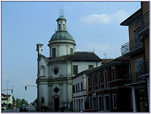
Cadeo
| Cadeo | ||
|---|---|---|

|
|
|
| Country | Italy | |
| region | Emilia-Romagna | |
| province | Piacenza (PC) | |
| Local name | (La) Cadé | |
| Coordinates | 44 ° 58 ' N , 9 ° 49' E | |
| height | 65 m slm | |
| surface | 38.6 km² | |
| Residents | 5,971 (Dec 31, 2019) | |
| Population density | 155 inhabitants / km² | |
| Post Code | 29010 | |
| prefix | 0523 | |
| ISTAT number | 033007 | |
| Popular name | Cadini | |
| Website | Cadeo | |
Cadeo is an Italian commune ( comune ) with 5971 inhabitants (as of December 31, 2019) in the province of Piacenza in Emilia-Romagna . The municipality is located about 13.5 kilometers southeast of Piacenza . The administrative center of the municipality is in the district of Roveleto .
history
The name of the community comes from a field hospital that was built in 1112 under the name La Casa del Dio .
traffic
The A1 Autostrada runs through the municipality from Milan to Rome . State road 9 from Bologna to Piacenza runs roughly parallel to this . In the district of Roveleto there is a train station on the Milan – Bologna railway line.
Community partnerships
Cadeo has a partnership with the Maltese municipality of Marsaxlokk ( Marsa Scirocco ) in the Malta Xlokk region .
Web links
Commons : Cadeo - collection of images, videos and audio files
Individual evidence
- ↑ Statistiche demografiche ISTAT. Monthly population statistics of the Istituto Nazionale di Statistica , as of December 31 of 2019.


