
Carrodano
| Carrodano | ||
|---|---|---|

|
|
|
| Country | Italy | |
| region | Liguria | |
| province | La Spezia (SP) | |
| Coordinates | 44 ° 15 ' N , 9 ° 39' E | |
| height | 215 m slm | |
| surface | 20.97 km² | |
| Residents | 486 (Dec. 31, 2019) | |
| Population density | 23 inhabitants / km² | |
| Post Code | 19020 | |
| prefix | 0187 | |
| ISTAT number | 011010 | |
| Popular name | Carrodanesi | |
| Patron saint | Santa Felicita | |

Carrodano (in Ligurian : Carödanu ) is an Italian commune with 486 inhabitants (as of December 31, 2019) in the Liguria region . Politically, it is in the province of La Spezia .
geography
The municipality is located in the Val di Vara and forms part of the Comunità Montana dell'Alta Val di Vara . Carrodano is in two large community centers, Carrodano Inferiore and Carrodano Superiore , divided and consists of the housing estates Canegreca , Costa Pereto , Piana , Ferriere , dates , Arsina and Mattarana .

Carrodano
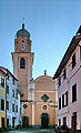
Chiesa di Santa Felicita

alley


Sons and daughters of the church
- Italo Santelli (1866–1945), fencer
Web links
Individual evidence
- ↑ Statistiche demografiche ISTAT. Monthly population statistics of the Istituto Nazionale di Statistica , as of December 31 of 2019.

Ameglia | Arcola | Beverino | Bolano | Bonassola | Borghetto di Vara | Brugnato | Calice al Cornoviglio | Carro | Carrodano | Castelnuovo Magra | Deiva Marina | Follo | Framura | La Spezia | Lerici | Levanto | Maissana | Monterosso al Mare | Ortonovo | Pignons | Porto Venere | Riccò del Golfo di Spezia | Riomaggiore | Rocchetta di Vara | Santo Stefano di Magra | Sarzana | Sesta Godano | Varese Ligure | Vernazza | Vezzano Ligure | Zignago