
Framura
| Framura | ||
|---|---|---|

|
|
|
| Country | Italy | |
| region | Liguria | |
| province | La Spezia (SP) | |
| Coordinates | 44 ° 13 ' N , 9 ° 32' E | |
| height | 50 m slm | |
| surface | 18 km² | |
| Residents | 629 (Dec. 31, 2019) | |
| Population density | 35 inhabitants / km² | |
| Post Code | 19014 | |
| prefix | 0187 | |
| ISTAT number | 011014 | |
| Popular name | Framuresi | |
| Website | www.comune.framura.sp.it | |
 View of Framura |
||

Framura ( Ligurian Framûa ) is an Italian municipality with 629 inhabitants (as of December 31, 2019) in the province of La Spezia in Liguria and is a member of the association I borghi più belli d'Italia (The Most Beautiful Places in Italy).
Geography and church structure

Framura is located in a rugged bay on the Ligurian Riviera di Levante (Coast of the Rising Sun).
The municipality consists of the five localities ( fractions ):
- Anzo
- Castagnola
- Costa
- Ravecca
- Setta (seat of the municipal administration)
The Serro mountain (421 m) is the highest point in the municipality of Framura and part of the Cinque Terre National Park . Until 2009, the municipality was part of the now dissolved Comunità Montana della Riviera Spezzina administrative community .
history
Archaeological finds prove the presence of the Ligurians in the region of today's Framura . At the time of the Roman Empire , the place had the status of a pagus and was owned by the monastery of San Colombano di Bobbio since the Lombard era and in the Middle Ages it passed into the possession of the Da Passano family, who originally came from the village of the same name near Deiva Marina originated and left some fortifications from the 9th century.
In 1170, Count von Lavagna from the Fieschi family occupied the castle of Frascario and the Lords of Passano were driven out. After a long controversy, the castle returned to Genoa .
Like all Italian Tyrrhenian coasts, Framura had to defend itself against Islamic incursions over the centuries, as the three watchtowers still show today.
1797, the municipality of Framura re-entered the department of Vara with the capital Levanto in the Ligurian Republic with the Napoleonic rule from December 2nd . From April 28, 1798, Framura again belonged to the seventh canton with the capital Deiva Marina with the new French regulations . From June 13, 1805 to 1814 with the era of the First French Republic , the place was included in the Apennines department . From 1815 it belongs to the Kingdom of Sardinia . From 1859 to 1927 the area was reassigned to the province of Genoa and included in the province of La Spezia .
From 1973 to December 31, 2008 it was part of the mountain community of the Spezzina Riviera.

Carolingian watchtower
( torre carolingia )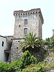
Genoese watch tower
( torre genovese )


Population development
| year | 1861 | 1871 | 1881 | 1901 | 1911 | 1921 | 1931 | 1936 | 1951 | 1961 | 1971 | 1981 | 1991 | 2001 | 2016 |
| population | 1119 | 1236 | 1230 | 1193 | 1236 | 1383 | 1256 | 1282 | 1216 | 1042 | 972 | 913 | 839 | 744 | 655 |
Attractions


- Religious landmarks
- Parish Church of San Lorenzo in Castagnola
- Parish Church of San Martino in Costa
- Other structures
- Carolingian Tower of Costa
- Coastal bike path Maremonti to Bonassola and on to Levanto
- botany
- Botanical garden of Monte Serro
Festivals, celebrations and commemorations
- Festa della Madonna della Neve , on the first Sunday of August in Porticciolo, religious commemoration of those who have died in the sea
- Festa di San Rocco on August 16
- Festa di Santa Lucia on the last Sunday of August
- Festa patronale di San Lorenzo on August 10th in Castagnola
sons and daughters of the town
Economy and Infrastructure

Many residents of the community pursue their income mainly in tourism. Otherwise there are small, family-run shops.
A railway station on the Pisa – Genoa railway connects the community with the neighboring villages and with La Spezia and Sestri Levante .
Web links
Individual evidence
- ↑ Statistiche demografiche ISTAT. Monthly population statistics of the Istituto Nazionale di Statistica , as of December 31 of 2019.
- ^ I borghi più belli d'Italia. Borghipiubelliditalia.it, accessed July 27, 2017 (Italian).
- ↑ Portal of the Ligurian mountain communities in liquidation ( Memento of the original from April 17, 2016 in the Internet Archive ) Info: The archive link was inserted automatically and has not yet been checked. Please check the original and archive link according to the instructions and then remove this notice.
- ↑ History notes about Framura at framura.eu, accessed on May 31, 2020.
- ^ History of the rapid cycle route , (Italian), ciclopedonalemaremonti website for the Maremonti coastal cycle route, accessed on April 24, 2018.
- ↑ Framura at cinqueterre.eu, accessed on May 31, 2020.

Ameglia | Arcola | Beverino | Bolano | Bonassola | Borghetto di Vara | Brugnato | Calice al Cornoviglio | Carro | Carrodano | Castelnuovo Magra | Deiva Marina | Follo | Framura | La Spezia | Lerici | Levanto | Maissana | Monterosso al Mare | Ortonovo | Pignons | Porto Venere | Riccò del Golfo di Spezia | Riomaggiore | Rocchetta di Vara | Santo Stefano di Magra | Sarzana | Sesta Godano | Varese Ligure | Vernazza | Vezzano Ligure | Zignago