
Civitavecchia port
| Civitavecchia port | |||
|---|---|---|---|
| Data | |||
| UN / LOCODE | ITCVV | ||
| operator | Port Authority of Civitavecchia ( ADSP del Mar Tirreno centro-settentrionale ) Porti di Roma e del Lazio |
||
| opening | 110 AD | ||
| Port type | Freight and passenger port | ||
| Total area of the port | 200 hectares without water | ||
| Passengers | 4,140,184 (2016) | ||
| Throughput | 11.5 million t (2016) | ||
| website | www.portidiroma.it | ||
| Geographic information | |||
| place | Civitavecchia | ||
| region | Lazio | ||
| Country | Italy | ||
 |
|||
| Coordinates | 42 ° 5 '35 " N , 11 ° 47' 3" E | ||
|
|||

The port of Civitavecchia ( Italian Porto di Civitavecchia ) is a seaport on the Mediterranean coast of the central Italian region of Lazio . It is not only the port of the city of Civitavecchia , it is also the seaport of the Italian capital Rome, 70 kilometers south-east . Together with the smaller ports of Fiumicino and Gaeta, it is managed by a port authority which has its seat in Civitavecchia and which appears externally under the name Porti di Roma e del Lazio .
Emperor Trajan had the port moored between 107 and 110 AD. Today it is the leading port in Italy for the cruise business .
Infrastructure
The port facilities cover around 200 hectares of land. The shore length of all quay walls is a total of about 15 kilometers with 28 berths between 100 and 400 meters in length and other berths for yachts and boats . The rocky harbor basin is up to 18 meters deep.
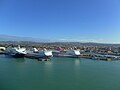
The port can be divided into three areas: the old port in the south is primarily a yacht and passenger port, the new port in the north is the industrial port. This has had a container terminal since 2009 with an annual capacity of 500,000 TEUs , which is to be doubled in the coming years. There is also a so-called “steel terminal”, which is important for the steelworks in Terni, Umbria , a car terminal for 280,000 vehicles, an oil port and various other facilities. Inland, the industrial port has free development areas of around 500 hectares. The third area is the port side of the two-kilometer-long pier , which has been converted into a pier for cruise ships . The Bramante and Amerigo Vespucci cruise terminals are located there . The pier in the south is still connected to the old port, but this connection is to give way to a second port entrance. The cruise terminals would then be connected to the rest of the port with a bascule bridge .
The landmark of the port and the city is the renaissance castle Forte Michelangelo at the old port . On the outer pier of the port is the statue of Santa Fermina .

Forte Michelangelo
Ferry port

Industrial port

mole


traffic
The port is important not only for Civitavecchia, Rome and Latium, but also for the southern parts of Tuscany , Umbria and in some respects the rest of central Italy . The city of Rome and other central Italian tourist attractions have contributed to the positive development of the cruise segment. Due to the central location of the port on the west coast of Italy, the so-called motorways of the sea play an important role. There are numerous ferry connections to Sicily and Sardinia , but also to Spain and Tunisia . The total number of passengers, including cruises and ferry traffic, was over 4.1 million in 2016, and goods handled almost 11.5 million tons.
Because of the proximity of Rome, the port is occasionally used for military purposes. Most of the time, it is about visits to fleets by foreign navies or public events by the Italian navy .
history

Emperor Trajan built the port from 107 onwards, following the pattern of the Portus Romae, which was expanded shortly before that (at Ostia Antica at the mouth of the Tiber ). The new port of Centumcellae should complement this. According to the standard of the time, the new port had a circular port basin with a diameter of around 500 meters, two piers and an artificial island at the port entrance. The Fortino di San Pietro , the remains of a lighthouse, has been preserved from this period .
After the end of the Western Roman Empire , the port belonged to the Byzantine Empire from the 6th to the 8th centuries . Around the year 800 Centumcellae was repeatedly attacked by the Saracens , who were defeated in the 849 naval battle of Ostia . For security reasons, Pope Leo IV had the residents of the place relocated in 854 to a hill that was easier to defend. When the area around the old port was repopulated around the year 1000, it was given the name Civita Vetula or "Old City".
After the harbor town definitely in the 15th century to the Papal States had come, began with the construction of fortifications and extended the harbor, which also naval base of the papal Navy was. In November 1659 the foundation stone was laid for the naval arsenal planned by Gian Lorenzo Bernini , which had great economic importance for the city for a long time. In addition, the grain supply to Rome at that time ran through the port of Civitavecchia.
During the Second World War , the city and port were badly destroyed by numerous air raids . The arsenal, the watchtowers, the old lighthouse and the Bramante fortress fell victim to the hail of bombs in 1943. Functional criteria were in the foreground during the reconstruction, the remaining architectural monuments were neglected for a long time. At the turn of the millennium, interest in the preservation of monuments increased again; Various structural measures have upgraded the port in both functional and cultural terms in recent years.
Web links
Individual evidence
- ↑ a b www.portidiroma.it Traffico merci, passeggeri e automezzi. Anni: 2016-2015 (Italian).