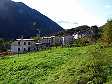
Stavoli
Stavoli is an abandoned northern Italian farming village with no access road in the Carnic Alps about 7 km west of Moggio Udinese in the Friuli-Venezia Giulia region . The village is supplied via a material cable car. Stavoli can be reached after a two and a half hour walk from Moggio Udinese, on the A23 motorway .
Historically, Stavoli, furlan i Stâi , is a medieval foundation of the San Gallo Monastery in Moggio. Despite the altitude of 567 m above sea level, the area at the foot of Monte Palevierte ( 1785 m above sea level ) is very suitable for growing vegetables.
Since there are no access roads, the village can only be reached by people via mule tracks. The main path continues via Campiolo di Sopra through the Torrente Glagno gorge, where you cross the high-speed railway Pontebbana from Tarvisio to Udine by means of a tunnel. From the path, the material cable car can be seen again and again, which crosses the valley at a great height. The path is relatively steep and leads over many steps along the gorge. The other route, which takes around one and a half hours, comes from Moggessa di Là . This is steeper on both sides to the west and less traveled than the one between Moggio and Moggessa. The Torrente Glagno, over which there is no bridge, has to be waded through at a ford. The brook is about 40 cm deep at the ford in normal water. As in Moggessa, there are ruins of a mill here too. The grain was brought down into the ravine to be ground and the flour then up again.
Stavoli is located on a slightly larger ridge that offers significantly more agricultural land than in Moggessa. Due to the easier transport of building materials via the cable car, single-axle tugs serve as a means of transport between the village and the cable car stations , the houses are in a much better condition than in the neighboring villages. Due to the natural conditions (the areas around the village suitable for fields are significantly more extensive than in Moggessa) it was the largest village. Most of it is used as holiday accommodation, but more people live in Stavoli than in the neighboring villages without access roads. The place looks very compact, almost like a small town. As in the neighboring villages, there are also many examples of rural architecture reduced to the essentials, which is characteristic of this poor mountain area. The houses, made entirely of stone, are high and have up to four storeys. The name Stavoli refers to houses made of natural stone and wood. There are common wells in the middle of the villages. The outside chimneys are also typical for the Fogolâre, the open stoves in Friuli. For a farming village, architectural style elements of the 19th century such as exterior stucco and richly decorated entrance doors are striking .
Today there are gardens, potato fields, fruit trees and small-scale vineyards around the village. Most of the agricultural work has to be done by hand. Several single-axle tractors show that motorized agricultural machinery is used here to a lesser extent. This is also used to transport goods between the village and the remote cable car station. One of the farmers grows lavender, which is sold in Venzone . A memorial plaque on house no. 70 refers to the house where the Friulian poet Egiziano Pugnetti (1847–1917) was born. Outside in the fields there is a towerless church, here too without a cemetery.
Water and electricity connections made the very lonely life in the mountains a little easier, especially in winter. Because of its geographic location, the village suffered less damage from the 1976 earthquake than other nearby villages. Emergency quarters in containers were not possible here either. Stavoli is seen as a village that has the potential to experience revitalization due to the renovation work. Around half of the 71 houses belong to people from the surrounding area. The vacant houses have good renovation potential.
The six-hour circular hike through the three Carnic villages of Moggessa di Quà , Moggessa di Lá and Stavoli, all three without access roads, which the Moggio Abbey has as its starting and ending point, is considered one of the “most beautiful and extraordinary day hikes” in Friuli.
Every year in June, the village festival "Fuc di San Pieri" takes place in Stavoli.
Web links
Individual evidence
- ↑ Roland Löffler, Michael Beismann, Judith Walder, Ernst Steinicke: New Highlanders in traditional migration areas of the Alps. The example of the Friulian Alps. Revue de Géographie Alpine / Journal of Alpine Research 102/3, 2014, accessed on March 24, 2016 .
- ^ Pilgram, Gerhard / Berger, Wilhelm / Koroschitz, Werner: The last valleys hiking and stopping off in Friuli. University cultural center UNIKUM (editor), Klagenfurt 2008, pp. 113–121.
Coordinates: 46 ° 25 '18 " N , 13 ° 9' 2.8" E


