
Pontebba
| Pontebba | ||
|---|---|---|

|
|
|
| Country | Italy | |
| region | Friuli Venezia Giulia | |
| Coordinates | 46 ° 30 ' N , 13 ° 18' E | |
| height | 568 m slm | |
| surface | 97 km² | |
| Residents | 1,348 (Dec. 31, 2019) | |
| Population density | 14 inhabitants / km² | |
| Post Code | 33016 | |
| prefix | 0428 | |
| ISTAT number | 030076 | |
| Popular name | Pontebbans | |
| Patron saint | San Pietro | |
| Website | Pontebba | |


Pontebba ( Friulian : Pontêbe or Ponteibe , German : Pontafel , Slovenian : Pontabelj / Tablja ) is a municipality with 1,348 inhabitants (as of December 31, 2019) in the Friuli-Venezia Giulia region .
Place name
The name is derived from the Italian word Ponte (in German: bridge). One can also assume that the Latin expression pons viae (German: bridge of the street ) or ad pontem viae (German: to the bridge of the street ) was the inspiration. The names Pontevia , Pontieba , Ponteva and even Pontaiba for this piece of land can already be read in old documents .
geography
Aupa (900 m), Pietratagliata (520 m), Pontebba (565 m), San Leopoldo ( Leopoldskirchen , 603 m), Studena Alta (888 m) and Studena Bassa (630 m) are districts. The main town of Pontebba is located in the Canal Valley . Pastor J. Kuchler kept weather records in the late 1860s. It was found that the climate here was already significantly milder than in the rest of Carinthia.
Flowing waters
The Fella as the main flow takes up the flowing north torrent Pontebbana. Before this flows into the Fella, it unites in the local area with the Rio Bombaso (German: Bombach ), which drains the Nassfeld region . A little further up, the Pontebbana is reinforced by the Rio Studena.

history
The village is crossed by the Pontebbana torrent , which until 1919 marked the Italian-Austrian and at the same time the Friulian-German language border by dividing the place into two communities: Pontebba (Italy-Veneto) and Pontafel (Austria-Hungary, Carinthia ) . The boundary between the Romance and the Germanic language families was also particularly evident visually, as travel reports from the 18th and 19th centuries describe. On the right side of the Pontebba brook was the Venetian, urban-looking Pontebba, characterized by high stone buildings with tiled roofs, and on the left, the Carinthian, village-like Pontafel, characterized by wooden houses with shingle roofs.
In 1900 Pontafel, the Austrian part of the village, had 804 inhabitants. 744 of them were German (93%), 12 Slovenian (1%) and 48 foreigners (6%).
In 1874 the telegraph came to Pontafel. The opening of an imperial and royal state telegraph station with "limited daily services" took place at the same time as in other smaller places in the monarchy.
With the annexation to Italy after the First World War , Pontafel was given the name Pontebba Nuova in 1918 and was united with Pontebba with a ceremony on August 15, 1924. On September 20, 1926, the formerly independent municipality of San Leopoldo Laglesie (Leopoldskirchen) was incorporated as a district of Pontebbas.
The decrease in the population (1911: 4591 inhabitants, 1951: 3931 inhabitants, 2005: 1768 inhabitants) is due not least to the economic situation of the municipality.
The Friuli-Venezia Giulia region is keen to build a cable car on the Italian side of the Nassfeld. With the construction of the railway, Pontebba would have a direct connection to the Nassfeld winter sports region in Carinthia's Gailtal .
Attractions


- The three-aisled, Gothic parish church of Santa Maria Maggiore with a carved winged altar from 1517. The original small church from the 12th century was rebuilt in 1504 by the architect Johann Komauer . The portal was created by Decio Deotto from Verzegnis 1903. The windows of the choir show neo-Gothic stained glass. A wooden crucifix from the 16th century hangs in front of the upper wall of the triumphal arch .
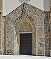
The portal of the Church of S. Maria Maggiore

The interior view

Partial view of a glass window in the choir room

Crucifix on the triumphal arch

Right aisle

Altar of the left aisle


- The Church of San Giovanni Battista , St. John the Baptist.

West facade with portal of the Church of S. Giovanni Battista

inside view

The altar of the left aisle


- The Palazzo municipale , the town hall, built in 1923 by the architect Provino Valle , with a staircase that is well worth seeing.
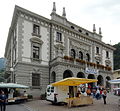
Town hall in Pontebba with market

View into the stairwell of the town hall

Partial view of the wrought iron gate of the town hall


Events
Festival of the "Tae" (Carneval)
Together with Leopoldskirchen (San Leopoldo) the population celebrates the festival of the "Tae". Other names for this festival are "Festa del cioch" or "Ploch". It takes place on the penultimate Sunday of the carnival season. At this celebration, the values of careful treatment of the environment, spouses and family come into play.
At the time of the Austro-Hungarian monarchy, barren areas were granted special economic benefits so that their inhabitants did not have to emigrate. It was about the then valid "easement rights".
The only condition for the handover of a Christmas tree ("Tae") by the neighborhood to the village youth was that no wedding was celebrated during Carnival. The young men cut down the tree themselves, and the girls help them decorate it. Colorful strips of paper and fabric are attached to the fir branches. At the very top hangs an evergreen wreath, from which a black and a white ribbon hang down. In the middle of the wreath there is a sign: “Mourning of the virgins, joy of the boys”. However, if the inscription read "joy of the girls, sorrow of the boys", the festival did not take place, which meant that a wedding was celebrated during the carnival season. With the two colors black and white, the two opposing feelings were expressed.
The “Tae” is pulled through the streets of Pontafel, whereas nowadays a tractor is used instead of horses. Following the old custom, the bridge over the Pontebbana stream is not crossed even today. The river bed marked the border between Austria and Italy until the end of the First World War, Pontafel was the Austrian border town, Pontebba the Italian one. The pageant leaves no house in town. It expresses brotherhood and compassion. All families visited receive the pageant in a special way.
The mask design should also be emphasized. Simple costumes and ancient props are used to emphasize the simplicity of the festival.
The “Tae” used to be set up at the end of the day in the old main square in front of the Impero coffee house, where it was auctioned to support the Carnival. With the proceeds (nowadays the "Tae" is sold in advance), as well as the money collected during the move including the gifts from the residents (ie sausages such as "muset" and sauerkraut), a joint dinner is held at the end, at which all residents of the imperial Participate in the Pontafel. The following night the party continues at masked balls. After the rediscovery of this custom, San Leopoldo (Leopoldskirchen) was also included in the festivities. This is where the pageants of both towns meet.
Nativity Market (September 8th)


Every year on September 8th, at the time of the Birth of Mary, a market is held in the center of Pontebba, where everyday items such as clothes, shoes, tools, sweets and household items are sold.
As early as 1342, the Patriarch Bertrand von Aquileia gave Pontafel the right to hold the market. Traders, farmers and craftsmen from Veneto, Carniola , Carinthia and Bohemia used to meet here at the market . The farmers brought cattle from the Gailtaler Almen, the Flitscher ( Bovec ) sheep and goats, the Kanaltaler their draft oxen and cabbage. The Venetians supplied rovings and silk fabrics, salted and dried fish, and the Friulians produced fruit, cheese, wines and green beans. The Carniolan and the Bohemian shopkeepers marketed hats and loden goods. The gingerbread makers from Carinthia offered honey and sweets for sale and the local blacksmiths from Malborgeth and Pontafel sold iron goods. The market once lasted six days and was reduced to three days after the First World War.
Surrounding mountains
Over the Cereschiatis saddle to Moggio Udinese
The continuously paved and laid out mountain road from Pontebba via the mountain village of Aupa to Moggio Udinese leads into the wild and romantic Aupatal . The road winds over the abyss of the Pontebbana torrent over the village of Studena Alta, framed by alpine meadows, the village of Aupa built into the slope like a beehive up to the Cereschiatis pass at 1,085 meters, and then on a winding descent first through the wooded high valley of the Aupa stream, then descend at the bottom of a canyon-like valley floor past steep rocky slopes towards Moggio Udinese.

Studena Alta, district of Pontebba

View from Aupa to the Zuc del Bor

Cereschiatis Pass between Pontebba and the Aupa Valley
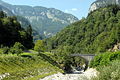
Bridge of Nassfeldstrasse over the Rio Bombaso


On the Nassfeld
In a northerly direction from Pontebba there is an asphalt pass road, which is only passable in the summer months, to the Carnic Alps and the Naßfeld (1552 m above sea level) to the Austrian border.
Over the Cason di Lanza pass to Paularo
Another mountain road, this time in a north-westerly direction from Pontebba, leads to remote alpine pastures with dairies . The path leads along the Pontebbana torrent up to the origin of the Cason di Lanza pass at an altitude of 1,552 m, from where mountain tours to the Trogkofel (2,279 m), the Rosskofel (Monte Cavallo) (2,229 m) and the Monte Zermula (2,143 m) can be started. A winding route then leads downhill from the village of Paularo to the Chiarzo torrent.
literature
- Edizione del Comune di Pontebba: Pontebba: 1000 anni di cronaca. Olmis, 2005, ISBN 88-7562-036-9 .
- Anna Zanier, Claudio Canton, Roberto Carollo and others: La strada ferrata della Pontebba. Senaus, Udine 2006, ISBN 88-901571-5-1 .
- Val Canale. (= Guida del Friuli. VII). Societá Alpina Friulana, Udine 1991, OCLC 440664250 .
- Roberta Costantini, Fulvio Dell'Agnese, Micol Duca, Antonella Favaro, Monica Nicoli, Alessio Pasian: Friuli-Venezia Giulia. I luoghi dell'arte. Bruno Fachin Editore, Triest 1999, ISBN 88-85289-57-6 , pp. 273-274.
- Karl Migglautsch, Ingomar Pust: The Canal Valley and its history. Publisher of the Kanaltaler Kulturverein. Klagenfurt 1995, ISBN 3-901088-04-0 .
- G. Pilgram , W. Berger, W. Koroschitz, A. Pilgram-Ribitsch: The last valleys. Hiking and stopping off in Friuli. Drava Verlag, Klagenfurt / Celovec 2008, ISBN 978-3-85435-532-8 .
Web links
Individual evidence
- ↑ Statistiche demografiche ISTAT. Monthly population statistics of the Istituto Nazionale di Statistica , as of December 31 of 2019.
- ↑ Johann Prettner: The climate of Carinthia based on observations made at 42 observation stations. (Specially reprinted from the yearbook of the Natural and Historical State Museum of Carinthia XI). Klagenfurt, print by Ferdinand von Kleinmayr, 1872, OCLC 1075693140 , pp. 91-92 (old page) ( entry Digitalna knjižnica Slovenije , article pdf , both dlib.si ), accessed on November 7, 2019.
- ↑ Kurt F. Strasser, Harald Waitzbauer, Across the borders to Triest (Vienna 1999), pp. 44–46.
- ↑ KK Statistische Central-Commission: Special-Orts-Repertorien of the kingdoms and countries represented in the Austrian Reichsrathe. Volume V: Carinthia. Vienna 1905, p. 90.
- ↑ Announcements. In: Klagenfurter Zeitung , December 10, 1874, p. 6 (online at ANNO ).

Aiello del Friuli | Amaro | Ampezzo | Andreis | Aquileia | Arba | Arta Terme | Artegna | Attimis | Aviano | Azzano Decimo | Bagnaria Arsa | Barcis | Basiliano | Bertiolo | Bicinicco | Bordano | Brugnera | Budoia | Buja | Buttrio | Camino al Tagliamento | Campoformido | Campolongo Tapogliano | Caneva | Capriva del Friuli | Carlino | Casarsa della Delizia | Cassacco | Castelnovo del Friuli | Castions di Strada | Cavasso Nuovo | Cavazzo Carnico | Cercivento | Cervignano del Friuli | Chions | Chiopris Viscone | Chiusaforte | Cimolais | Cividale del Friuli | Claut | Clauzetto | Codroipo | Colloredo di Monte Albano | Comeglians | Cordenons | Cordovado | Cormons | Corno di Rosazzo | Coseano | Dignano | Doberdò del Lago | Dogna | Dolegna del Collio | Drenchia | Duino-Aurisina | Enemonzo | Erto e Casso | Faedis | Fagagna | Fanna | Farra d'Isonzo | Fiume Veneto | Fiumicello Villa Vicentina | Flaibano | Fogliano Redipuglia | Fontanafredda | Forgaria nel Friuli | Forni Avoltri | Forni di Sopra | Forni di Sotto | Frisanco | Gemona del Friuli | Gonars | Gorizia | Gradisca d'Isonzo | Grado | Grimacco | Latisana | Lauco | Reading Nice | Lignano Sabbiadoro | Lusevera | Magnano in Riviera | Majano | Malborghetto Valbruna | Maniago | Manzano | Marano Lagunare | Mariano del Friuli | Martignacco | Medea | Meduno | Mereto di Tomba | Moggio Udinese | Moimacco | Monfalcone | Monrupino | Montenars | Montereale Valcellina | Moraro | Morsano al Tagliamento | Mortegliano | Moruzzo | Mossa | Muggia | Muzzana del Turgnano | Nimis | Osoppo | Ovaro | Pagnacco | Palazzolo dello Stella | Palmanova | Paluzza | Pasian di Prato | Pasiano di Pordenone | Paularo | Pavia di Udine | Pinzano al Tagliamento | Pocenia | Polcenigo | Pontebba | Porcia | Pordenone | Porpetto | Povoletto | Pozzuolo del Friuli | Pradamano | Prata di Pordenone | Prato Carnico | Pravisdomini | Precenicco | Premariacco | Preone | Prepotto | Pulfero | Ragogna | Ravascletto | Raveo | Reana del Rojale | Remanzacco | Résia Valley | Resiutta | Rigolato | Rive d'Arcano | Rivignano Teor | Romans d'Isonzo | Ronchi dei Legionari | Ronchis | Roveredo in piano | Ruda | Sacile | Sagrado | San Canzian d'Isonzo | San Daniele del Friuli | San Dorligo della Valle | San Floriano del Collio | San Giorgio della Richinvelda | San Giorgio di Nogaro | San Giovanni al Natisone | San Leonardo | San Lorenzo Isontino | San Martino al Tagliamento | San Pier d'Isonzo | San Pietro al Natisone | San Quirino | San Vito al Tagliamento | San Vito al Torre | San Vito di Fagagna | Santa Maria la Longa | Sappada | Sauris | Savogna d'Isonzo | Savogna di Cividale | Sedegliano | Sequals | Sesto al Reghena | Sgonico | Socchieve | Spilimbergo | Staranzano | Stregna | Sutrio | Taipana | Talmassons | Tarcento | Tarvisio | Tavagnacco | Terzo d'Aquileia | Tolmezzo | Torreano | Torviscosa | Tramonti di Sopra | Tramonti di Sotto | Trasaghis | Travesio | Treppo Grande | Treppo Ligosullo | Tricesimo | Trieste | Trivignano Udinese | Turriaco | Udine | Vajont | Valvasone Arzene | Varmo | Venzone | Discount | Villa Santina | Villesse | Visco | Vito d'Asio | Vivaro | Zoppola | Zuglio