Pfatten
| Pfatten | |
|---|---|
| (Italian: Vadena ) | |
| coat of arms | map |
| State : | Italy |
| Region : | Trentino-South Tyrol |
| Province : | Bolzano - South Tyrol |
| District community : | Überetsch-Unterland |
|
Inhabitants : (VZ 2011 / 31.12.2019) |
1.021 / 1.050 |
|
Language groups : (according to 2011 census ) |
38.06% German 61.50% Italian 0.44% Ladin |
| Coordinates | 46 ° 25 ′ N , 11 ° 18 ′ E |
| Altitude : | 243 m slm |
| Surface: | 13.51 km² |
| Permanent settlement area: | 6.8 km² |
| Neighboring municipalities: | Eppan , Bozen , Branzoll , Kaltern , Leifers , Auer , Tramin |
| Postal code : | 39051 |
| Area code : | 0471 |
| ISTAT number: | 021105 |
| Tax number: | 80006580213 |
| Mayor (2015): | Alessandro Beati (list of citizens) |
Pfatten ( Italian Vadena ) is a municipality with 1050 inhabitants (as of December 31, 2019) in the South Tyrolean Unterland in Italy , south of Bolzano . Pfatten is one of the five municipalities in South Tyrol with an Italian-speaking majority of the population.
geography
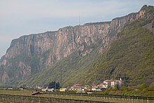
Pfatten is located in the Unterland , a section of the Adige Valley in the south of South Tyrol. The 13.51 km² municipal area extends as a long, narrow strip, in parts on both sides of the Adige , starting from the outskirts of Bolzano in the north over a length of over 10 km towards the south. The small village center (230- 240 m slm ) as well as most other hamlets and settlements of the municipality (Birti, Garnel, basement, Mair, Neupfatten, Piglon, Schenk, Stadlhof-Laimburg Wachsbleiche) are on the limited area between the right bank (western) banks of the Etsch and the foot of the elongated Mitterberg , which separates the Unterlandler valley floor from the elevated hilly landscape of the Überetsch . Two other villages are located in the extreme south of the municipality, where Pfatten crosses the Mitterberg: Klughammer on the banks of Lake Kalterer - connected to the rest of the municipality via the Kreiter Sattel - and Gmund .
Neighboring communities of Pfattens are in the north of Bozen, along the lower valley floor east of the Etsch Leifers , Branzoll and Auer , in the south Tramin and to the western Überetsch Kaltern and Eppan .
history
Pfatten is mentioned in 855 - 864 as "Vatina" , 1242 as "Fatena" , 1296 as "Pfetten" and 1371 as "Phætena" . The place name could be of Raetian origin. The small area is known in archaeological circles for its Late Bronze and Early Iron Age cemetery Stadlhof . Pfatten belonged to the former Laimburg regional court , as evidenced by a document from 1488 with the indication "Pháttenn inn Laymburger gericht" . It was awarded by the Tyrolean sovereigns to the Lords of Rottenburg until 1410 , before it was only issued jointly with the Kaltern court from the 15th century.
The Pfatten fire brigade was founded in December 2005 as the youngest volunteer fire brigade in South Tyrol .
Education and Research
In the village center of Pfatten there is both a German-speaking and an Italian-speaking primary school , both of which are administered separately by the school districts located in Laives .
The Laimburg experimental center is an agricultural research facility in the Pfattner municipality . In the immediate vicinity there also a German and an Italian-speaking college for fruit, wine and horticulture consist vocational school programs .
Worth seeing
The main destination is the ruins of the Leuchtenburg at an altitude of 576 m on a hilltop of the Mitterberg, from which hikers can enjoy a view of Lake Kaltern , the Dolomites and the Adige Valley . A little below the Leuchtenburg on the Kreiter Sattel is the Laimburg .
politics
mayor
Mayor since 1952:
- Alberto Mosna: 1952–1974
- Alfredo Mosna: 1975–1990
- Carlo Mosna: 1990-2005
- Alessandro Beati: since 2005
coat of arms
The coat of arms from 1969 shows the Mitterberg , with the Kreiter saddle and the Laimburg in the middle. Below that are two stripes that represent the Brenner motorway and the Adige .
Driving safety center in Pfatten
A modern driving safety center has existed in the north of the Pfatten municipality since 2008 .
literature
- Georg Tengler, Maria Luise Kiem (Red.): Pfatten. Landscape and history . Athesia, Bozen 1991
- Fabrizio Miori (Coord.): Al di là del ponte. Vadena: storia e immagini = over the bridge. Pfatten: pictures and stories . Ed. La Fabbrica del Tempo / Die Zeitfabrik, 2011 (online) .
Web links
- Official website of the municipality of Pfatten
- Entry in the Tirol Atlas of the Institute for Geography at the University of Innsbruck
- Landscape plan of the municipality of Pfatten . Office for Landscape Ecology, Autonomous Province of Bolzano - South Tyrol (PDF file)
Individual evidence
- ^ Egon Kühebacher : The place names of South Tyrol and their history. Volume 1. Athesia: Bozen 1995. ISBN 88-7014-634-0 , p. 311.
- ↑ Diether Schürr: To the origin of Tramin - Termeno . In: Archivio per l'Alto Adige , 99–100 / 2005–2006, pp. 405–424.
- ^ Hannes Obermair : Bozen Süd - Bolzano Nord. Written form and documentary tradition of the city of Bozen up to 1500 . tape 2 . City of Bozen, Bozen 2008, ISBN 978-88-901870-1-8 , p. 197, No. 1241 .
- ↑ Otto Stolz : Political-historical description of the country of South Tyrol. Part 2: Quarter on the Adige. Innsbruck: Wagner 1938, p. 202 ( online )
- ↑ Laives school district. South Tyrolean Citizens' Network , accessed on October 26, 2014 .
- ↑ School district of Laives 1st South Tyrolean Citizens' Network, accessed on October 26, 2014 .
- ^ Technical school for fruit, wine and horticulture 'Laimburg'. South Tyrolean Citizens' Network, accessed on October 26, 2014 .
- ↑ Gustav Pfeifer, Christian Terzer: Laimburg . In: Magdalena Hörmann-Weingartner (ed.), Tiroler Burgenbuch. Volume X: Überetsch and South Tyrolean Unterland . Athesia Publishing House, Bozen 2011, ISBN 978-88-8266-780-1 , pp. 267-280.
- ↑ The mayors of the South Tyrolean municipalities since 1952. (PDF; 15 MB) In: Festschrift 50 Years of the South Tyrolean Association of Municipalities 1954–2004. Association of South Tyrolean municipalities, pp. 139–159 , accessed on November 16, 2015 .


