Ahrntal (municipality)
| Ahrntal | |
|---|---|
| (Italian: Valle Aurina ) | |
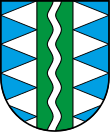
| coat of arms | |
| State : | Italy |
| Region : | Trentino-South Tyrol |
| Province : | Bolzano - South Tyrol |
| District community : | Val Pusteria |
|
Inhabitants : (VZ 2011 / 31.12.2019) |
5.911 / 6.015 |
|
Language groups : (according to 2011 census ) |
98.76% German 0.93% Italian 0.31% Ladin |
| Coordinates | 47 ° 0 ′ N , 11 ° 59 ′ E |
| Altitude : | 942– 3418 m slm (center: 1054 m slm ) |
| Surface: | 187.28 km² |
| Permanent settlement area: | 15.5 km² |
| Parliamentary groups : | Luttach , Steinhaus , St. Jakob, St. Johann , St. Peter, Weißenbach |
| Neighboring municipalities: | Brandberg ( Tyrol ), Finkenberg ( Tyrol ), Mayrhofen ( Tyrol ), Mühlwald , Prettau , Sand in Taufers |
| Partnership with : | Haar (near Munich) ( D ) |
| Postal code : | 39030 |
| Area code : | 0474 |
| ISTAT number: | 021108 |
| Tax number: | 00342270212 |
| Mayor (2015): | Helmut Klammer (SVP) |
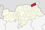
Ahrntal ( Italian: Valle Aurina ) is an Italian municipality with 6015 inhabitants (as of December 31, 2019) in South Tyrol . It covers most of the Ahrntal valley of the same name . The main town of the Ahrntal community is Steinhaus .
geography
The municipality of Ahrntal covers most of the Ahrntal , which the Ahr flows through. The valley section, which together with smaller side valleys and the surrounding mountain areas belongs to the municipality of Ahrntal, begins in the south near the narrow point, which is understood as the border to the Tauferer Tal and where the border to the neighboring municipality of Sand in Taufers runs. In the north it ends at the narrow point between St. Peter and Prettau , known as the gorge (e) .
The most important village settlements in the 187.28 km² municipality of Ahrntal, all of which, with the exception of Weißenbach, are located in the main valley, are from south to north:
- Luttach (950- 1020 m slm ) at the output of Weißenbachtals,
- Weissbach (1320- 1370 m ) in Weißenbachtal , a branching to the west side valley,
- St. Johann (1000- 1030 m ), also briefly Ahrn called
- Steinhaus (1040- 1070 m ), the capital of the municipality,
- St. Jakob (1170- 1210 m ) and
- St. Peter (1260 1430 m ) near the municipal border with Prettau.
In the north, west and south-west the community is framed by mountains of the Zillertal Alps . The main ridge of the Zillertal or the main Alpine ridge , which borders the valley in the north , also forms the Italian-Austrian border with the state of Tyrol . The Turnerkamp ( 3418 m ), the Hornspitzen (including the 3253 m high III. Hornspitze ), the Schwarzenstein ( 3369 m ), the Große Löffler ( 3379 m ), the Wollbachspitze ( 3210 m ) and the Napfspitze ( 3144 m ). The mountain range in the west and southwest, in which u. a. the Tristenspitze ( 2716 m ) and the Speikboden massif rise up, separating the communities of Ahrntal and Mühlwald in the Mühlwalder Valley . In the southeast, the Durreck group, belonging to the Venediger group, delimits the community from the Reintal with the village of Rein in Taufers with the Durreck ( 3135 m ) and the Hirbernock ( 3010 m ) . Large parts of the Durreck Group are protected as part of the Rieserferner-Ahrn Nature Park .
history
The municipality of Ahrntal (Comune Valle Aurina) was founded in 1926 from the small communities Luttach , St. Johann , St. Jakob, St. Peter and Prettau with headquarters in Steinhaus. In 1958 Prettau was spun off and has since formed an independent community again.
Attractions
- South Tyrolean Mining Museum , Steinhaus granary and Prettau mine with climatic tunnel
- Showroom on the archeology of the Ahrntal in the Pfisterhaus (opened October 2015)
- Kichler Mineral Museum in St. Johann
- Maranatha Crib Museum in Luttach
- Oberkofler Museum in St. Johann
- Plate saw in St. Johann
- Nature park branch in Prettau
economy
The most important branch of the economy is tourism (5,400 guest beds and over 430,000 overnight stays per year). In summer there are cycling, climbing and hiking opportunities in the Rieserferner-Ahrn Nature Park, and the numerous peaks of the surrounding mountain ranges also offer demanding mountaineers plenty of opportunities (crossing the northern or northeastern mountains and crossings leads alpinists to Austria earlier times used increasingly by smugglers); in winter, the nearby ski areas Klausberg and Speikboden are just as inviting as numerous cross-country ski trails, toboggan runs, ski touring and hiking opportunities. The Kronplatz is also close by. The Western Horse Ranch in Luttach and the Schwarzbachalm above Luttach with a nature adventure playground are available for adventure tourism. Important tourist attractions are the Mineral Museum in Steinhaus, the Mining Museum in Steinhaus and the Nativity Museum in Luttach.
education
The municipality of Ahrntal is the seat of a school district in German. This includes the six primary schools in Luttach, St. Jakob, St. Johann, St. Peter, Steinhaus and Weißenbach, as well as the middle school in St. Johann. The primary school in the neighboring municipality of Prettau is also connected to the school district.
The headquarters of the public library of the Ahrntal community is in St. Johann.
particularities
Throughout South Tyrol, the Ahrntal is often referred to only as "Toul" (in German simply "Tal" or "das Tal"), while the inhabitants of the Ahrntal are called "Tölderer" (in dialect "Teldra").
In the Ahrntal there are over 50 managed alpine pastures (many of them also in winter). In addition, Ahrntaler farmers manage several alpine pastures in the Krimmler Achental , which were acquired between 1812 and 1873. The valley is surrounded by over 80 three-thousand-meter peaks .
politics
- South Tyrolean People's Party : 10
- Teldra Citizen List : 6
- South Tyrolean Freedom : 2
Mayor since 1952:
- Josef Oberhollenzer: 1952–1964
- Johann Kirchler: 1969–1986
- Josef Kirchler: 1986–1991
- Josef Gottfried Kirchler: 1991–1995
- Hubert Rieder: 1995-2010
- Helmut Klammer: since 2010
Personalities
- Heinrich Gasteiger (* 1957), cook, specialist teacher and specialist book author
- Bruno Klammer (* 1938), theologian, author and publisher
- Karin Knapp (* 1987), tennis player
- Norbert Niederkofler (* 1961), cook
- Josef Oberhollenzer (* 1955), author
- Johann Baptist Oberkofler (1895–1969), priest and painter
- Joseph Georg Oberkofler (1889–1962), lawyer and author
Panorama map
literature
- The Ahrntal: local history contributions . Der Schlern 52/1978, H. 7/8.
- Municipality of Ahrntal (Ed.): Ahrntal: a municipality book . With contributions by Christoph von Hartungen , Ernst Hofer, Reimo Lunz, Lydia Reichegger, Walburg Tanzer, Hannes Obermair , Gertrud Egger, Brigitte Niederkofler, Mathias Schmelzer, Sieglinde Hofer, Margareth Kamelger and Martha Verdorfer. Steinhaus 1999 (online) .
- Rudolf Tasser: The Obermair medicine book from St. Jakob in the Ahrntal . In: Wolfgang Ingenhaeff (Hrsg.): Mountain people and medicine . Berenkamp, Innsbruck 2005, ISBN 3-85093-202-8 , pp. 321-370.
- Tauferer Ahrntal. History and future . Tappeiner, Lana 2007, ISBN 978-88-7073-420-1 .
- Josef Duregger, Stefan Felder, Johanna Müller: Teldra Dialektpüich. With Gschichtlan fan Toule. Edition Raetia, Bozen 2009, ISBN 978-88-7283-365-0
- Paul Gruber, Franz Josef Künig (eds.): Peter Wasserer 1822 to 1845 , Provincial Publishing House, Brixen 2010
Web links
- Homepage of the municipality of Ahrntal
- Landscape plan of the municipality of Ahrntal . Office for Landscape Ecology, Autonomous Province of Bolzano - South Tyrol (PDF file)
- History-Tyrol: Ahrntal
- Entry in the Tirol Atlas of the Institute for Geography at the University of Innsbruck
Individual evidence
- ^ Ahrntal school district. South Tyrolean Citizens' Network , accessed on October 25, 2014 .
- ↑ Gebhard Kirchler: Ahrntaler Almen in the Krimmler Achental. St. Johann in Ahrn 2018.
- ↑ The mayors of the South Tyrolean municipalities since 1952. (PDF; 15 MB) In: Festschrift 50 Years of the South Tyrolean Association of Municipalities 1954–2004. Association of South Tyrolean municipalities, pp. 139–159 , accessed on November 16, 2015 .


