Ahr (Rienz)
|
Ahr Ahrn, Ahrnbach |
||
|
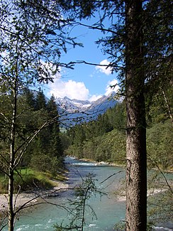
Ahr in the Haxaue between Luttach and Sand in Taufers |
||
| Data | ||
| location | South Tyrol , Italy | |
| River system | Etsch | |
| Drain over | Rienz → Eisack → Etsch → Adriatic Sea | |
| source | below the pear gap 47 ° 4 ′ 59 ″ N , 12 ° 12 ′ 38 ″ E |
|
| muzzle | at Bruneck coordinates: 46 ° 47 ′ 34 " N , 11 ° 55 ′ 21" E 46 ° 47 ′ 34 " N , 11 ° 55 ′ 21" E |
|
| Mouth height |
810 m slm
|
|
| length | 52.3 km | |
| Catchment area | 629 km² | |
| Drain |
MQ |
15.2 |
| Left tributaries | Reinbach , Mühlbach | |
| Right tributaries | Keilbach , Weißenbach , Mühlwalder Bach | |
| Communities | Prettau , Ahrntal , Sand in Taufers , Gais , Bruneck | |
The Ahr (also Ahrn , Ahrnbach ; Aurino in Italian ) is around 52.3 km long and has a catchment area of around 629 km² and is the most important tributary of the Rienz in South Tyrol in northeast Italy . It flows through the Tauferer Ahrntal .
geography
The Ahr rises at around 2500 m above sea level below the Birnlücke in the Venediger group . The headwaters are part of the Rieserferner-Ahrn Nature Park . In its upper reaches, the Ahr crosses the Ahrntal with a considerable gradient , where numerous streams from the Zillertal Alps and the Venediger group flow into it (such as the Keilbach and the Weißenbach ). At sand it reaches the Tauferer Tal on the Tauferer Boden . Here it takes its two longest tributaries, the Reinbach and the Mühlwalder Bach . In the further course of the broad, almost flat Tauferer Valley, it reaches a last significant tributary from the Rieserferner group with the Mühlbach . In Bruneck the Ahr finally enters the Pustertal where they to 810 m height in the Rienz opens.
Places on its banks are Prettau , St. Jakob , Luttach , Sand in Taufers , Mühlen in Taufers , Uttenheim , Gais and St. Georgen (in that order).
Hydrology
From a hydrological point of view, the Ahr is the upper reaches of the Etsch , as it is the larger river at its confluence with the Rienza, the Rienz in turn surpasses the Eisack in terms of water flow and when it converges with the Etsch it carries more water than it. In addition, the Ahr-Rienz-Eisack-Etsch river sequence forms the longest flow path of all rivers in the Adige river system.
Name history and etymology
The Ahr has changed its name several times in the course of history. The oldest known form of name from 893 is Pirra . Possibly the river Byrrhus, mentioned by Venantius Fortunatus in the 6th century, can be identified as the Ahr. With Pirra or Pirre was until the 11./12. Century not only denotes the Ahr, but also the entire lower course of the Rienz from Bruneck; Only then did the river name Rienz , originally only valid in the upper reaches, also establish itself in the western Puster Valley . In the course of the 16th century, the old river name gradually disappeared in the Tauferer and Ahrntal. The name Pirlbach can only be traced back to the 18th century in Prettau . The Birnlücke mountain pass , under which the Ahr rises, is still reminiscent of the original name. The etymology of Pirra is unclear. Karl Finsterwalder is thinking of a derivation from the Indo-European root * bhers- with the meaning "to hurry", which enables an interpretation as "hasty gutter". Egon Kühebacher, however, thinks of a relationship with the Greek pyr ("fire") and thus explains the Ahr as Rotbach .
In the 16th century the name Achenbach became common. Ache is a very common hydronym in the Alpine region , and in the vernacular the body of water was simply called Grundbach . Presumably these generic names motivated modern geographers to create the name Ahrnbach for the largest river in the Ahrntal - a rare example of naming a river after the valley it flows through. The shortened form of the name Ahr (initially still occasionally Ahrn ) can only be documented in the 19th century.
Web links
- Ahr on the website of the South Tyrolean Environment Agency
- Current water levels
Individual evidence
- ↑ a b [1] of the Autonomous Province of Bolzano - South Tyrol
- ↑ Martin Bitschnau , Hannes Obermair : Tiroler Urkundenbuch, II. Department: The documents on the history of the Inn, Eisack and Pustertal valleys. Volume 1: By the year 1140 . Universitätsverlag Wagner, Innsbruck 2009, ISBN 978-3-7030-0469-8 , p. 81 ff., No. 112 and 218 .
- ^ Johannes Ortner: Pipe, Pirra, Pustertal. Exploring the naming landscape in the Bruneck basin . Lecture given on February 7, 2017 in Bruneck.
- ^ Egon Kühebacher: The place names of South Tyrol and their history. Volume 2. Bozen: Athesia 1995. ISBN 88-7014-827-0 , p. 17.
- ^ Johannes Ortner: Pipe, Pirra, Pustertal. Exploring the naming landscape in the Bruneck basin . Lecture given on February 7, 2017 in Bruneck.
- ^ Egon Kühebacher: The place names of South Tyrol and their history. Volume 2. Bozen: Athesia 1995. ISBN 88-7014-827-0 , p. 17.

