
Sand in Taufers
| Sand in Taufers | |
|---|---|
| (Italian: Campo Tures ) | |
coat of arms
 |
map  |
| State : | Italy |
| Region : | Trentino-South Tyrol |
| Province : | Bolzano - South Tyrol |
| District community : | Val Pusteria |
|
Inhabitants : (VZ 2011 / 31.12.2019) |
5,272 / 5,517 |
|
Language groups : (according to 2011 census ) |
97.34% German 2.30% Italian 0.36% Ladin |
| Coordinates | 46 ° 55 ' N , 11 ° 57' E |
| Altitude : | 838– 3436 m slm (center: 864 m slm ) |
| Surface: | 164.47 km² |
| Permanent settlement area: | 10.8 km² |
| Parliamentary groups : | Ahornach , Kematen, Mühlen in Taufers , Rein in Taufers |
| Neighboring municipalities: | Ahrntal , Gais , Mühlwald , Percha , Prettau , Rasen-Antholz , Sankt Jakob in Defereggen ( East Tyrol , A ) |
| Postal code : | 39032 |
| Area code : | 0474 |
| ISTAT number: | 021017 |
| Tax number: | 81003390218 |
| Mayor (2015): | Sigfried Steinmair ( SVP ) |
Sand in Taufers ( Italian Campo Tures ) is an Italian market town with 5517 inhabitants (as of December 31, 2019) in the northeast of South Tyrol . The main town of the municipality is the village of Sand in the Tauferer Valley .
geography
The 164.47 km² municipal area of Sand in Taufers is mainly composed of two parts: on the one hand, a section of the Tauferer Valley with several villages, and on the other hand, the sparsely populated Reintal branching off from it .
Sand in Taufers includes the northernmost section of the Tauferer Valley, the valley widening called Tauferer Boden , above the neighboring municipality of Gais to the south . At the northern end of the Tauferer Boden lies the main town of the municipality, Sand in Taufers (860– 900 m slm ). To the north behind Sand, the municipality extends into the beginning of the Ahrntal , where the border to the Ahrntal municipality is also located. Slightly southwest of sand in the bottom of the valley are Taufer first locality Taufers and then at the output of Mühlwalder valley and at the border with Muehlwald the fraction mills in Taufers (850 870 m ). Mills, where the Mühlwalder Bach in the Ahr flows, is in the northwest of the Zillertal Alps counted Speikboden dominated massif. On the opposite side of the valley eastern the fraction is Kematen (850 860 m ). Northeast above the valley floor, finally, the fraction is at the point where the Reintal from the Taufer Valley East branches off Ahornach with its small center (1300- 1350 m located) and scattered farms.
The Reintal, which runs in a west-east direction and drained by the Reinbach , takes by far the largest part of the municipality of Sand in Taufers. The main town of the valley, Rein in Taufers (1540- 1590 m ) is surrounded on three sides by mighty mountain ridges, which to a large extent in the Rieserferner-Ahrn are placed under protection. The high valley is bordered to the north by mountains of the Venediger group , which are assigned to the Durreck group to the west of the Ochsenlenke . The highest peaks here are the Große Moosstock ( 3059 m ), the Durreck ( 3135 m ) and the Hirbernock ( 3010 m ). The ridges on the east side (south of the Klammljoch , a transition to East Tyrol ) and south side of the Reintal belong to the Rieserferner group . In the east, on the Italian-Austrian border with the state of Tyrol , there are (from north to south) the Dreieckspitze ( 3031 m ), Lenkstein ( 3236 m ), Fenneregg ( 3123 m ), Patscher Spitze ( 3082 m ) and Barmer Spitze ( 3200 m ) m ). In the southeast of the valley is the Hochgall ( 3436 m ), the highest point in the municipality. Of from there towards the west trending to the Taufer Valley Crest also contributes significant peaks, including the the south-facing Antholzer valley dominant Wildgall ( 3273 m ), the above the Western Vedrette constituent Magerstein ( 3273 m ), the Fernerköpfl ( 3248 m ), the Schneebigen Nock ( 3358 m ), the Gelttalspitze ( 3126 m ), the Black Wall ( 3105 m ), the Morgenkofel ( 3073 m ) and the Große Windschar ( 3041 m ).
history

The first mention of Taufers as "Tvfres" found in Brixen Traditionsbuch for the period 1050 - 1065 , the name "Sand Maurizien" (for Moritzen) and "Sant" (for the main town sand = Gries and river sediment that of the Verebnung Tauferer Boden forms) appear only in 1296 and 1410 respectively. The Tauferer Boden and the Tauferer Feld are attested in 1334 as "Touver field" and in 1360 as "Tauffers field" .
Since the late Middle Ages, Taufers, with its central point of sand, has formed its own regional court , for which there is a detailed description from 1834 by the then regional judge Augustin von Leys.
The community as it is today was formed in 1926 during the fascist era under the official and exclusive name of "Campo Tures" from the eight small communities Sand, Third Sand, Ahornach, Rein, Kematen, Mühlen, Mühlwald and Lappach. The latter two were soon separated and have since formed the Mühlwald community .
The place was the terminus for the Tauferer Bahn until 1957 .
politics
- South Tyrolean People's Party : 14
- Alliance of Taufers 2010 : 4
Mayor since 1952:
- Josef Oberhollenzer: 1952–1956
- Josef Eppacher: 1956–1969
- Josef Beikircher: 1969–1980
- Toni Innerhofer: 1980-2005
- Helmuth Innerbichler: 2005–2015
- Sigfried Steinmair: since 2015
economy
Thanks to the mining activities of the 15th and 16th centuries in the Ahrntal Valley, Sand in Taufers briefly became the seat of the Taufers mountain court and its own mountain judge , one of the central Tyrolean control centers for early modern primary production. After its rapid ebb, Taufers had only a subordinate economic importance until the middle of the 19th century. This in turn changed with the advent of tourism and mountaineering from the late 19th century. In particular, the opening of the ski area on the Speikboden in 1973 brought a great boom. Today the community has more than 180 hotels with 3,500 guest beds and 390,000 overnight stays per year.
In September 2011 the Cascade opened its doors, a combination of swimming pool, sauna and wellness area. The municipality hopes that this major project will provide new impetus for tourism.
Trade and industry also play an important role, especially in the valley floor, whereas agriculture is only of secondary importance today.
Social
Social housing in South Tyrol was only spun off from state welfare in 1972 as a result of the autonomy provisions; In 1974 the South Tyrolean Housing Institute had the first residential units of the regionally subsidized housing built in Campo Tures (Daimerstraße).
education
Sand in Taufers is the seat of a German-speaking school district . This includes the three primary schools in Sand, Ahornach and Rein as well as the middle school in Sand. The two primary schools in the neighboring municipality of Mühlwald are also connected to the school district.
In Sand, the only secondary schools in the Tauferer Ahrntal are located in the Sand in Taufers secondary school center , which offers a technical college for business and tourism, a high school for social sciences and a vocational school for care and social affairs.
Sports
The SSV Taufers has been organizing a three-day international handball tournament in the youth field every year for 30 years .
Attractions

Josef Langl's view of the Taufers parish with Kematner Strasse, St. Michael and Mesnerhaus from 1908

Zeilheim Residence: Old Town Hall

Mutschlechnerhaus (Doctoral House)

Taufers Castle and Neumelans Residence (in the foreground)
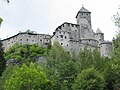
Taufers Castle

Stockmair in Kematen (residential tower from the 13th century)

Reinbach Falls


Sons and daughters
- Josef Daimer (1845–1909), alpine pioneer
- Josef Beikircher (1850–1925), industrial pioneer
- Johann Niederwieser , called Stabeler (1853–1902), mountain guide
- Emil von Ottenthal (1855–1931), historian
- Josef Moriggl (1879–1939), mountaineer
- Josef Andreas Jungmann (1889–1975), Jesuit, liturgist and councilor
- Heinrich Forer (1913–1997), auxiliary bishop of the Diocese of Bozen-Brixen
- Josef Innerhofer (* 1931), theologian and publicist
- Erich Achmüller (* 1946), politician
- Helga Thaler Ausserhofer (* 1952), politician (South Tyrolean People's Party)
- Erich Kirchler (* 1954), business psychologist and university professor
- Martha Stocker (* 1954), politician (South Tyrolean People's Party)
- Hans Kammerlander (* 1956), extreme mountaineer and skier
- Barbara Ertl (* 1982), biathlete
Web links
- Website of the municipality of Sand in Taufers
- Landscape plan of the municipality of Sand in Taufers . Office for Landscape Ecology, Autonomous Province of Bolzano - South Tyrol (PDF file)
- Entry in the Tirol Atlas of the Institute for Geography at the University of Innsbruck
Individual evidence
- ^ Oswald Redlich : The tradition books of the Brixen monastery: from the tenth to the fourteenth century (Acta Tirolensia 1). Innsbruck: Wagner 1899, p. 50 No. 130.
- ^ Emil von Ottenthal , Oswald Redlich: Archive reports from Tyrol. Volume III. Vienna-Leipzig 1910, p. 365 No. 1802 and 1806.
- ↑ Walther Neuhauser: A description of the Taufers regional court from 1834. The "topographical-statistical representation of the Taufers regional court" by the regional judge Augustin von Leys. With edition of the text. In: Publications of the Landesmuseum Ferdinandeum 21, 2001, pp. 5–71.
- ↑ The mayors of the South Tyrolean municipalities since 1952. (PDF; 15 MB) In: Festschrift 50 Years of the South Tyrolean Association of Municipalities 1954–2004. Association of South Tyrolean municipalities, pp. 139–159 , accessed on November 16, 2015 .
- ↑ Georg Schreiber: The mining in history, ethos and sacral culture. Wiesbaden: Springer 1962, p. 639ff.
- ↑ Hannes Obermair : The WOBI-IPES - a historical outline . Lecture from May 3, 2017, accessed on June 7, 2017.
- ↑ School district Sand in Taufers. South Tyrolean Citizens' Network , accessed on October 25, 2014 .
- ↑ Sand in Taufers secondary school center. South Tyrolean Citizens' Network, accessed on October 25, 2014 .

Abbey | Ahrntal | Aldein | Algund | Altrei | Andrian | Auer | Barbian | Bolzano | Branzoll | Burner | Brixen | Brunico | Burgstall | Corvara | Nova Ponente | Enneberg | Eppan | Feldthurns | Franzensfeste | Freienfeld | Gais | Gargazon | Glurns | Graun im Vinschgau | Casies | Avelengo | Innichen | Jenesien | Kaltern | Karneid | Kastelbell-Tschars | Castelrotto | Kiens | Klausen | Kuens | Kurtatsch | Kurtinig | Lasa | Laion | Lana | Laces | Laurein | Laives | Lüsen | Times | Margreid | Marling | Martell | Merano | Mölten | Montan | Moos in Passeier | Mühlbach | Mühlwald | Nals | Naturno | Naz-Sciaves | Neumarkt | Niederdorf | Olang | Partschins | Percha | Falzes | Pfatten | Pfitsch | Plausibility | Prad | Braies | Prettau | Proveis | Lawn Antholz | Ratschings | Riffian | Ritten | Rodeneck | Salurn | Sand in Taufers | Sarntal | Schenna | Schlanders | Schluderns | Schnals | Sexten | St. Christina in Val Gardena | St. Leonhard in Passeier | St. Lorenzen | St. Martin in Passeier | St. Martin in Thurn | St. Pankraz | Ortisei in Val Gardena | Sterzing | Stilfs | Taufers im Münstertal | Terenten | Terlan | Tiers | Tyrol | Tesimo | Toblach | Tramin | Truden | Tscherms | Ulten | Our Lady in the Walde-St. Felix | Vahrn | Villandro | Villnöß | Vintl | Fiè allo Sciliar | Verano | Waidbruck | Monguelfo Tesido | Welschnofen | Wengen | Selva in Val Gardena