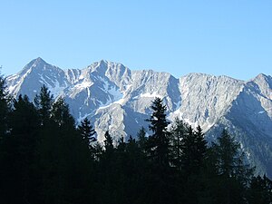
Big wind crowd
| Big wind crowd | ||
|---|---|---|
|
Large wind group from the north (far left), right of it the small wind group, far right the waterfall tip |
||
| height | 3041 m slm | |
| location | South Tyrol , Italy | |
| Mountains | Rieserferner Group | |
| Coordinates | 46 ° 53 '23 " N , 12 ° 1' 3" E | |
|
|
||
| Type | Rock peaks | |
| First ascent | August 5, 1878 by Rudolf Seyerlen and Stefan Kirchler from the northeast and the southeast ridge | |
| Normal way | Grubscharte and southeast ridge | |
| particularities | impressive panorama | |
The Große Windschar ( Italian Cima del Vento Grande , also called Lanebachspitze ) is a 3,041 meter high mountain in the Rieserferner group , a mountain range in the western part of the Hohe Tauern . It is located in the Italian province of South Tyrol in the Rieserferner-Ahrn Nature Park ( Parco Naturale Vedrette di Ries-Aurina ). The evenly shaped mountain has the shape of a steep pyramid and sends out strongly pronounced ridges to the north, south-east and west. Because of its easy accessibility, the summit was climbed as early as 1854 as part of the Franziszeische land survey , but is still popular with tourists today because of its impressive panoramic view. The first touristic ascent, precisely documented in the literature, took place on August 5th, 1878 by the Jena professor of philosophy and alpinist Rudolf Seyerlen with the mountain guide Stefan Kirchler from the Gelt valley, starting from the northeast over the southeast ridge. Today the wind crowd is mostly approached from the Mühlbach or Mühlbachtal in the south .
Location and surroundings
The Windschar lies at the western end of the Rieserferner main ridge, which curves from northeast to west . There are no glaciers in the immediate vicinity. Neighboring mountains in the course of the Große Windschar west ridge are the Kleine Windschar with a height of 2981 meters and, further away, the 2652 meter high waterfall peak . In the east, separated by the high-alpine route crossing of the Grubscharte (2802 m), the Große and Kleine Rauchkofel (3006 and 3043 meters above sea level). The south ridge leads over the Winterstallscharte (2474 m) to the Bramstaller (2559 m). The closest places to the west are Mühlen in Taufers in the Tauferer Tal, about 5 km away as the crow flies , and Mühlbach, about 5 km to the southwest.
Development and routes to the summit
The way of Rudolf Seyerlen and his guide in the summer of 1878 led from the Gelttal to the northeast over the Elferscharte (2841 m) and the Grubscharte over the southeast ridge to the summit. The philosopher Seyerlen fell into raptures on the summit in the best weather, quote: “ What makes a panorama particularly charming, in addition to the magnificence and richness of the mountain groups, is the view of the places of human culture, in valleys and settlements down, and in this respect I know In spite of the Cevedale and the Weißkugel, I don't have a tip that might dispute our rank [...] . ”In 1885, the Alpine Club created a trail that was supposed to enable even less experienced tourists to climb.
Even today, the Große Windschar is conquered over the southeast ridge (path of the first climbers) with easy climbing of difficulty level UIAA I over, however, brittle rock. The ascent to the southeast ridge typically begins in the Mühlbachtal to the south . Alternatively, you can also get from the Reintal, which runs north, through the Gelttal , which branches off to the south, up to the Elferscharte and from there to the Grubscharte and the southeast ridge in, according to literature, about 5 hours of walking time. Climbing is done on the Windschar on the north ridge; Due to the extremely solid tonalite rock there, climbing routes are worthwhile. In 1974, Hans Kammerlander and J. Volgger opened a serious tour over the north ridge with a key point of difficulty UIAA IV, which runs over 720 meters in altitude , but is rarely climbed due to its long approach.
Literature and map
- Hanspaul Menara : The most beautiful 3000m peaks in South Tyrol. 70 worthwhile alpine tours. Athesia, Bozen 2014. ISBN 978-88-8266-911-9
- Werner Beikircher, Karl Hellweger: Alpine guide Tauferer-Ahrntal. Hikes, mountain and ski tours. Athesia publishing house, Bozen 1981. ISBN 88-7014-205-1 , pp. 326–331
- Werner Beikircher: Alpine Club Leader Rieserferner Group . Bergverlag Rudolf Rother , Munich 1983. ISBN 3-7633-1227-7
- Helmut Dumler: Area Guide South Tyrol 3 . Bergverlag Rudolf Rother, Munich 1987. ISBN 3-7633-3300-2
- Casa Editrice Tabacco , Tavagnacco, hiking map 1: 25,000, sheet 035, Valle Aurina / Ahrntal, Vedrette di Ries / Rieserferner group
Individual evidence
- ^ A b Carl Diener in Eduard Richter : The development of the Eastern Alps . III. Volume, Berlin 1894, p. 125
- ^ Werner Beikircher: Alpine Club Leader Rieserferner Group . Bergverlag Rudolf Rother, Munich 1983, p. 108
- ^ Werner Beikircher: Alpine Club Leader Rieserferner Group . Bergverlag Rudolf Rother, Munich 1983, p. 181
- ^ Werner Beikircher: Alpine Club Leader Rieserferner Group . Bergverlag Rudolf Rother, Munich 1983, p. 183

