Western Rieserferner
| Western Rieserferner | ||
|---|---|---|
|
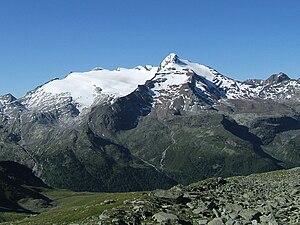
Snowy Nock and to the left of it the western Rieserferner (2011) |
||
| location | South Tyrol , Italy | |
| Mountains | Rieserferner Group | |
| Type | Mountain glacier | |
| surface | 1.97 km² (2009) | |
| Exposure | North | |
| Altitude range | 3327 m slm - 2570 m slm (2009) | |
| Coordinates | 46 ° 54 '23 " N , 12 ° 5' 49" E | |
|
|
||
| drainage | Reinbach → Ahr → Rienz → Eisack → Etsch | |
The western Rieserferner ( Italian Vedretta di Ries occidentale ) is 1.97 km² and is the largest glacier in the Rieserferner group in the western part of the Hohe Tauern . It is located south of the Bachertal , a source valley of the Reintal in South Tyrol . The north-exposed glacier is embedded between the northeast ridge of the Schneebigen Nock and the northeast ridge of the Magerstein . The latter ridge separates the glacier from the much smaller Eastern Rieserferner . The entire area is part of the Rieserferner-Ahrn Nature Park .
The glacier is divided into two areas by the morphology of the bedrock, especially in the Zehr area, and has two separate tongue ends . The altitude range extends from 3227 m down to 2570 m, with the eastern tongue being the lowest point. The central part of the glacier, where both tongues are still united, is heavily riddled with crevasses .
development
In the period from October 2009 to September 2010, the mass balance of the glacier was determined in cooperation with the Bozen Hydrographic Office and the Geographic Institute of the University of Innsbruck . A mass loss of 1.208 billion liters was determined during the investigation period. In relation to the area of the glacier, this corresponds to a water equivalent of 612 mm. In the absence of data, an exact comparison with the previous year is not possible. The balances of the hydrological year 2008/2009 for all South Tyrolean glaciers examined were on average between 20% and 40% less negative than the long-term average. From the determined change in the net balance per height range of the position was equilibrium line ( Equilibrium Line Altitude , ELA) determined with 3100 meters. The ratio of the accumulation area to the total area ( Accumulation Area Ration , AAR) was 17% during the study period.
In 1979 the glacier ended at an altitude of 2554 meters, at that time it still had a third tongue, the total area was 2.572 km². In 1925, the main tongue even reached down to 2,425 meters. The mass balance of the glacier was also determined in the period between 1977 and 1979; the proportion of the accumulation area (AAR) was 94% in the hydrological year 1977/78, which means that ablation only took place on 6% of the area . In the second hydrological year examined, 1978/79, the proportion of the accumulation area was 50%; in total, both examined hydrological years showed a slightly positive balance.

