Riffian
| Riffian | |
|---|---|
| (Italian: Rifiano ) | |
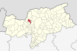
| coat of arms | map |
| State : | Italy |
| Region : | Trentino-South Tyrol |
| Province : | Bolzano - South Tyrol |
| District community : | Burgrave Office |
|
Inhabitants : (VZ 2011 / 31.12.2019) |
1,333 / 1,394 |
|
Language groups : (according to 2011 census ) |
97.76% German 1.85% Italian 0.39% Ladin |
| Coordinates | 46 ° 42 ' N , 11 ° 11' E |
| Altitude : | 504 m slm |
| Surface: | 35.75 km² |
| Permanent settlement area: | 2.9 km² |
| Parliamentary groups : | Magdfeld, Vernuer , Gfeis , Tschenn |
| Neighboring municipalities: | Kuens , Moos in Passeier , St. Leonhard in Passeier , St. Martin in Passeier , Schenna , Tyrol |
| Partnership with : | Inning am Holz , Germany |
| Postal code : | 39010 |
| Area code : | 0473 |
| ISTAT number: | 021073 |
| Tax number: | |
| Mayor (2015): | Franz Pixner ( SVP ) |
Riffian ([ ˈrɪfɪan ]; Italian : Rifiano ) is an Italian municipality with 1,394 inhabitants (as of December 31, 2019) in South Tyrol . It is located in Passeier north of Merano .
geography

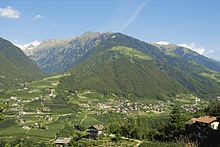
Riffian is located in the Burgraviato in Passeier . The municipality includes settlement areas in the Vorderpasseier as well as extensive mountain areas in the Texel group , which is part of the Ötztal Alps . The village center is located on the orographically right , western slope of the valley in the lower Passeier Valley at around 500 m above sea level in the immediate vicinity of the neighboring community of Kuens . In the valley floor, the Passer largely forms the eastern boundary of the municipality, only at the confluence of the Masulbach does the municipality briefly cross the river side. The steep slopes to the north above the Riffian village center offer space for the Vernuer fraction , whose courtyards stretch up to an altitude of 1400 m . This is where the protected mountainous area in large parts of the Texel Group Nature Park begins , in which the municipality crosses two mountain ridges and spans two side valleys. To the northwest behind the mountain ridge above Vernuer lies the Kalmtal , the upper area of which down to the hamlet of Magdfeld ( 1150 m ) belongs to Riffian (the lower area to the confluence with the Passeir main valley, however, belongs to St. Martin ). Further north - separated from the inner Kalmtal by the mountain ridge between the highest Riffian peaks, the Kolbenspitze ( 2868 m ) and the Rötenspitze ( 2878 m ) - the municipal area finally encompasses the majority of the uninhabited Faltmartal (a side valley of the Pfelders ) on the border with Moos in Hinterpasseier).
history
Riffian is mentioned as Riffian in 1116 , which is probably derived from the Latin personal name Rufius . In the Middle Ages Riffian gained importance as a place of pilgrimage to Mary. The municipality belonged to the judicial district of Merano until the end of the First World War and was part of the district of Merano . Today tourism plays an important role; 34.52% of the employees on site (status: 2001) work in the hotel and restaurant sector. The tourist attraction of Riffian is due in particular to the mild climate and the proximity to the spa town of Merano.
politics
town hall
The Riffian town hall not only serves the politics and administration of its own community, but is also used by the neighboring community of Kuens .
mayor
Mayor since 1952:
- Franz Laimer: 1952–1954
- Johann Pircher: 1954–1974
- Alois Pircher: 1974-1995
- Albin Kofler: 1995-2005
- Karl Werner: 2005–2015
- Franz Pixner: since 2015
Partnerships
Riffian's partner municipality is Inning am Holz near Erding .
Attractions
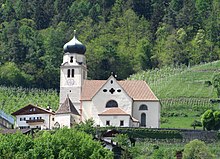
Pilgrimage Church "To the Seven Sorrows of Mary"
The baroque building by Franz Delai (1671) was preceded by a Gothic precursor (mentioned in 1310), details of which are not known. The church holds the miraculous image of a Gothic Pietà , a colored clay sculpture.
Chapel of Our Lady at the cemetery
The cemetery chapel is painted with late Gothic frescoes by a certain Master Wenceslaus (signature on a lion with a lettering, dated 1415), whose identity is still largely unexplored.
Archaeological finds
The Burgstall is a settlement from the late Iron Age (approx. 400 BC), which was founded in the 1st century BC. Fell victim to a fire. The central manor house has been excavated. Guided hikes there are u. a. organized by the South Tyrol Museum of Archeology in Bolzano .
The Riffian perforated stone , which was machined more than 4000 years ago, is in the village.
literature
- Matthias Thaler, Hubert Walder: Church leaders from Riffian . Riffian 1979.
- Mathilde Weger: Riffian - History of the village and its pilgrimage , 1983 ( online )
Web links
- Riffian parish
- Landscape plan of the municipality of Riffian . Office for Landscape Ecology, Autonomous Province of Bolzano - South Tyrol (PDF file)
- Entry in the Tirol Atlas of the Institute for Geography at the University of Innsbruck
Individual evidence
- ↑ The mayors of the South Tyrolean municipalities since 1952. (PDF; 15 MB) In: Festschrift 50 Years of the South Tyrolean Association of Municipalities 1954–2004. Association of South Tyrolean municipalities, pp. 139–159 , accessed on November 16, 2015 .


