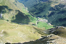
Pfelder valley

The Pfelderer Tal , also simply called Pfelders ( Italian Val di Plan ), is a side valley of Passeier in South Tyrol that branches off to the southwest near Moos .
The valley measures about 13 kilometers from Moos to Eisjöchl , a contradiction to the name , an ice-free transition to Pfossental in summer , a side valley of Schnalstal . On the north side, the Gurgler Kamm of the Ötztal Alps separates the Pfelder Valley from the Gurgler Valley , while the Texel Group rises to the south .
The only place in the valley is Pfelders , the valley is traversed by the Pfelder Bach , which flows into the Passer near Moos . Smaller side valleys branching off to the south are (from west to east) the Lazinser Tal, the Faltschnaltal, the Faltmartal and the Farmazontal. The Pfelder valley and almost all of its side valleys belong administratively to the municipality of Moos in Passeier , only the Faltmartal is largely part of the municipality of Riffian . Significant parts of the Pfelder Valley (with the exception of almost only the valley floor) are protected in the Texel Group Nature Park .
Web links
Coordinates: 46 ° 48 ′ 13 ″ N , 11 ° 6 ′ 53 ″ E