
Passeier


Passeier , also Passeier Valley ( Italian : Passiria , or Val Passiria ), is a mountain valley in South Tyrol ( Italy ), north of Merano .
geography
The valley of the Passer is a left side valley of the Etsch valley . It stretches from Merano almost 50 km northwards, later north-west to the Timmelsjoch ( state border with Austria and transition to the Ötztal ). On this route, the valley, which is morphologically divided into the front and rear pass eggs , includes different climatic and vegetation zones.
The Vorderpasseier rises from the edge zone of the Merano basin, which is characterized by vines and Mediterranean vegetation, over orchards and pastures to St. Leonhard in Passeier over a distance of approx. 20 km only gradually from approx. 500 m to approx. 700 m. It is framed on the east side by mountains of the Sarntal Alps and on the west side by the Texel group , which is included in the Ötztal Alps . Hinterpasseier above St. Leonhard, on the other hand, is natural, steeply rising and has an alpine climate; Until late spring there is still snow in the high areas. Waterfalls tumble from the mountain slopes; the small villages that live from alpine farming are mostly high above the valley floor. The road to Timmelsjoch (2,474 m) overcomes an altitude of almost 1,800 m over a distance of almost 30 km. The vegetation is high alpine; in summer the landscape is known for its extensive alpine rose fields . On the west side, Hinterpasseier is still accompanied by the Ötztal Alps, while the mountains on the east side are now part of the Stubai Alps .
Geologically, a distinction is made between the following zones in Passeier:
- the zone of the old gneiss at the valley entrance in the south
- the Schneebergzug in the center
- the Ötztal-Stubai-Kristallin in the north
Communities
The Passeir municipalities are:
- Kuens ,
- Moss ,
- Riffian ,
- St. Leonhard ,
- St. Martin .
Parts of the valley entrance area are also in the municipalities:
These form - with other communities - the district community Burggrafenamt .
Side valleys
The most important side valleys on the orographic right , western side are the Seebertal , the Pfelderer Tal , the Kalmtal and the Spronser Tal . Among the left side valleys are the Timmelstal and the Waltental .
etymology
The name "Passeier" (formerly also Passir, Parseyr, Passeyer ) goes back to the original Rhaeto-Romanic settlement and is probably due to the place name pra de sura or prasura "upper meadow". Comparable field names (Persura) also exist in the North Tyrolean Paznaun , where the field name Persutt ("lower meadow") also occurs. Various farm names, such as the Tscharfhof in Walten (Rhaeto-Romanic tscharva , "deer"), also refer to the early Rhaeto-Romanic population of the valley.
history
Because of its north-south location, Passeier was a historic long-distance trade route. Mule tracks connected it over the Timmelsjoch with the Ötztal and the upper Inntal on the one hand and over the Jaufenpass with Sterzing , the Brenner and Innsbruck on the other hand. Because of the fork in both pass routes, St. Leonhard was the strategically most important trading place in Passeier; there the horses were changed and the goods were handled. The most common family name in St. Leonhard, Haller , can be traced back to this , which in turn goes back to the Säumer ( salt freighters, also called Haller ) who transported salt from North Tyrol or wine from South and World Tyrol to Merano .
The road to Timmelsjoch was only paved in 1968 and is only passable beyond the last inn in Schönau (1571 m) in the snow-free summer months.
From the 14th century onwards, some ministerials acquired the right to rise to the lower nobility if they pledged to serve the Count of Tyrol with arms in the event of war; in return, this assured tax and duty exemption. 11 of these former peasant noble houses ( called Schildhöfe ) have been preserved in Passeier; one of them in Saltaus has been converted into an upscale hotel.
The most famous historical personality from Passeier is Andreas Hofer , the failed Tyrolean folk hero from St. Leonhard (executed in Mantua in 1810). His birthplace, the Sandwirt , is now a central tourist attraction with a documentation center, museum, two memorial chapels and a restaurant.
Economy and Infrastructure
Today tourism is the main industry of the Vorderpasseier. Traditional hotels and inns are aimed primarily at family vacationers and hikers. The historic Waalwege in the lower section of the valley have been converted into popular panoramic hiking trails. Alpine hiking areas are above all the area around the Hirzer, which is also a center for paragliding , and the Texel Group Nature Park , in which parts of the western valley flanks are protected.
At the end of 2013, the largest employer in the Passeier Valley, the international company Hoppe AG, announced the closure of its plant in St. Martin. 158 employees were affected.
In St. Martin in connection with a 18-hole created golf course , the new district Quellenhof (it. Sorgente ), a nearly year-round usable sports and wellness - resort upmarket.
The Hinterpasseier has only limited tourist facilities for the short summer season. Only the Pfelderer Tal , a side valley of the Passer that branches off at Moos, has a ski season even in winter.
Personalities
- Joseph Ennemoser (1787–1854), doctor and scientist in the field of mesmerism / animal magnetism in the forerunner of psychology
- Karl Gufler (1919–1947), resistance fighter and bandit
- Johannes Evangelist Haller (1825–1900), provicer of Trento and archbishop of Salzburg
- Josef Valentin Haller , former mayor of Merano and tourism pioneer
- Joseph Haller (before March 3, 1737–1773), painter at the time of the late baroque , main representative of the "Baroque Passeir Art School"
- Johann Haller (1844–1906), participant in Julius Payer's North Pole expedition
- Werner Heel (* 1982), ski racer
- Andreas Hofer (1767–1810), Tyrolean folk hero, and his descendants ( Hofer von Passeyr family )
- Georg Klotz (1919–1976), fighter for the unity of Tyrol
- Eva Klotz (* 1951), member of the South Tyrolean state parliament
- Philipp J. Pamer (* 1985), director and author
- Alexander Pamer , musician
- Josef Pichler ("Pseirer Josele") (1765–1854), first to climb the Ortler
- Herbert Pixner (* 1975), musician and presenter
- Evelin Lanthaler (* 1991), natural track tobogganing world champion 2015, European champion 2016
photos
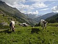
Alm in the Hinterpasseier
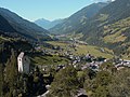
The Jaufenburg near St. Leonhard in Passeier

Hiking in the Passeier Valley


literature
- Manfred Schwarz: "People write to us from Passeier: ..." Curios and everyday things from newspapers from the monarchy 1848–1918. Verlag Passeier, St. Martin in Passeier 2018.
- Christine Tschöll: Resilience in the event of job loss. A case study in the peripheral Passeier Valley. Nomos, Baden-Baden 2018, ISBN 978-3-8487-4579-1 .
Web links
Individual evidence
- ↑ Christine Tschöll: Resilience in the event of job loss. A case study in the peripheral Passeier Valley. Nomos, Baden-Baden 2018, ISBN 978-3-8487-4579-1 .
Coordinates: 46 ° 47 ' N , 11 ° 13' E