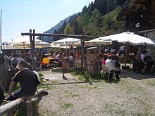
Kalmtal
The Kalmtal , also simply called the Kalm , is a valley in the Texel Group in South Tyrol and an orographically right , western side valley of Passeier . Administratively, it is divided: the lower section of the valley belongs to the municipality of St. Martin in Passeier (the farms and hamlets of the valley also form a separate fraction of the municipality), while the upper section of the valley belongs to Riffian .
The Kalmtal has over 300 inhabitants (2001 census).
geography
The valley
The valley is located in the eastern Texel group .
It is covered by meadows and forests and is located on the right (western) side of the Passeier Valley .
The Kalmbach
A stream, the Kalmbach , runs through the valley and flows into the Passer . In the past it was also used for the wood drift . Many tourists and locals like to visit it in summer.
A hydropower plant was built on this stream to generate electricity, which is owned by both the community and private investors. Another hydropower plant is now being planned, which will also be supplied with water from the Kalmbach.
The famous Passeir waterfall is also located on this stream.
The butt tip
The local mountain of the Kalm Valley is the Kolbenspitze, which offers a view of the Passeier Valley and the Burggrafenamt .
Alpine pastures
In the Kalmtal there are three alpine pastures , the Faglsalm, which is located at 1980 m and offers a wonderful view over the Passeier Valley, the Falseralm, which is located at 1929 m and at the end of the valley in the middle of the Texel Group Nature Park , and the Luimesalm. In addition, at the height of the Faglsalm is the Faglssee, which has been classified by the population as rather scary and dangerous since ancient times.
Place names in the Kalmtal
The Italian place names in italics were introduced in the course of the Italianization , but are not used today by either private or official sources.
| Locality | Italianized name | Associated hamlets or individual farms |
|---|---|---|
| Spath or Spat | - | Spathof |
| Neuhaus | Ponte Clava | Neuhaus-Hof; Lanthaler; Calf farmer |
| Kalmrausch (Kalmbach) | Rio della Clava | Calf; Passeirer Hof; Gift |
| Oj | - | Lower and upper shelf; Pfandler; former school |
| Wieden | Saletto | Unterwieden and Oberwieden |
| Tschaggen | Cava (in Passiria) | Inner and outer Tschager |
| Glamitz | - | Glamitzhof |
| Schupfer | Malánder | Schupferhof |
| Seeber | - | Seeberhof (attested as three farms as early as 1260 and as Chunzo Seber in the Kalmtal in 1390 ) |
| Brook | Masi del Rio | Unterbach and Oberbach; former school |
| Gruber | Cava | Gruberhöfe |
| Stone wall | Pietra | Unter- and Obersteinwandhöfe; Steinerhof |
| Eggenstein | Sasso | Unter- and Obereggensteinerhof |
| Magdfeld (Riffian) | Campo | Gasthof Magdfeld, Magdfeld-Hof |
| Naser | - | Naserhof snack station |
| Luimes | Lùimes | Luimeshof |
The primary schools in the Kalmtal
In the Kalmtal there were two schools, the primary school of Abl, which was attended by the children of the front Kalmtal and the primary school of Kalmtal, which was attended by the children of the rear Kalmtal.
Both schools have been closed in recent years. The primary school of Kalmtal due to the development of the Kalmtal through the Kalmtaler Straße, so these children could attend school in Abl. The primary school in Abl was closed a few years later because the maintenance of the lessons in Abl was associated with high costs and effort and so it was decided to close this school as well and to transport the students to St. Martin to attend school there .
Both school buildings have been sold and have already been converted into residential buildings.
economy
A large part of the population in the Kalmtal lives from mountain agriculture , with livestock farming being the top priority. For the most part, cows, sheep, goats, chickens and pigs are kept.
Agriculture
Since the mostly small farms (agriculture) usually do not produce a high yield, most farmers are forced to commute to another job in the morning. Another part of the employees in the Kalmtal is active in the construction industry.
tourism
The restaurants are known throughout South Tyrol and beyond. These businesses are now popular excursion destinations in Passeier and attract thousands of visitors to the high valley in the summer and autumn months.
traffic
The Kalmtal can be reached via the state road 44 via Meran or Sterzing . The Kalmtal can be reached by car from Merano in around 20 minutes.
The fraction has been accessible by motor vehicle since the late 1970s via Kalmtaler Straße, also via Gruber-Straße, Trifterweg and Peter-Mitterhofer-Straße. The Kalmtaler Straße leads through the Kalmtal and ends in the village of Magdfeld, which already belongs to the municipality of Riffian .
The Steinerhof is one of the few places in the Kalmtal that is very inconvenient, surrounded by rocks on all sides, and so it was previously not possible to access the Steinerhof by a path. The construction work to develop the courtyard began a few years ago, and the building project is financially supported by the state of South Tyrol.
In addition, several hiking trails lead through the Kalmtal, such. B. the Meraner Höhenweg .
Individual evidence
- ↑ Josef Tarneller : Tyrolean surnames: four thousand surnames that have their origin in Tyrolean and Vorarlberg court names. With many references and references, explanations of words and attempts at interpretation. Bolzano: Tyrolia 1923, p. 93.
Coordinates: 46 ° 46 ' N , 11 ° 11' E

