Pfitsch
| Pfitsch | |
|---|---|
| (Italian: Val di Vizze ) | |
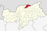
| coat of arms | map |
| State : | Italy |
| Region : | Trentino-South Tyrol |
| Province : | Bolzano - South Tyrol |
| District community : | Wipptal |
|
Inhabitants : (VZ 2011 / 31.12.2019) |
2,619 / 3,090 |
|
Language groups : (according to 2011 census ) |
90.98% German 8.94% Italian 0.08% Ladin |
| Coordinates | 46 ° 54 ′ N , 11 ° 28 ′ E |
| Altitude : | 943– 3509 m slm (center: 948 m slm ) |
| Surface: | 142.00 km² |
| Permanent settlement area: | 11.7 km² |
| Parliamentary groups : | Kematen, St. Jakob, meadows |
| Neighboring municipalities: | Brenner , Finkenberg (A), Freienfeld , Gries am Brenner (A), Mühlbach , Mühlwald , Sterzing , Vintl , Vals (Tyrol) |
| Partnership with : | Altdorf near Nuremberg ( DE ), District of Cuxhaven ( DE ) |
| Postal code : | 39049 |
| Area code : | 0472 |
| ISTAT number: | 021107 |
| Tax number: | 81005910211 |
| Mayor (2015): | Stefan Gufler ( SVP ) |
Pfitsch ( Italian Val di Vizze ) is one of the northernmost communities in South Tyrol in Italy with 3090 inhabitants (as of December 31, 2019). The municipality got its name from the Pfitscher valley in which it is located. Their main town is meadows at the entrance to the valley.
geography
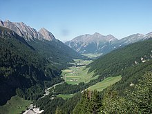
The municipality of Pfitsch is located in the north of South Tyrol, where it covers the entire Pfitsch valley and the surrounding mountains. The Pfitscher Valley - flowed through by the Pfitscher Bach - branches off from the Wipptal in a north-easterly direction near Sterzing and leads over 20 km into the Zillertal Alps before it ends at the Pfitscher Joch ( 2246 m slm ). The municipal area is 142.00 km².
The community is divided into the three fractions Wiesen , Kematen and St. Jakob , which in turn include a number of smaller hamlets, such as Flains, Moos, Burgum, Schmuders, Tulfer, Kematen, St. Jakob, Stein, Maibad, Ried, Rain, Pit, Kinzen, forest, meadows and train station.
The meadows fraction (940- 970 m ) is located at the mouth of the valley before the Sterzinger Basin. In this area, the Pfitsch municipality comes up to the Eisack and thus directly to the city center of Sterzing, which means that the Sterzing train station is actually in Pfitsch. In the south, the last section of the Pfitscher Bach before it flows into the Eisack forms the border to the neighboring community of Freienfeld . Kematen is roughly in the middle of the Pfitscher valley, while St. Jakob is the highest fraction.
The first section of the mountains that border the Pfitscher Valley in the north-west and north is the Tuxer Kamm . The most important peaks here include the Weißspitze ( 2714 m ), the Hühnerspiel ( 2790 m ), the Rollspitze ( 2776 m ), the Kalkwandstange ( 2386 m ), the Flatschspitze ( 2570 m ) and the Wolfendorn ( 2776 m ). The Schlüsseljoch ( 2212 m ) between Kalkwandstange and Flatschspitze forms a transition to Brennerbad in the municipality of Brenner . From the Wolfendorn, the mountain range north above the Pfitscher Valley, which now also bears the Italian-Austrian border with the state of Tyrol , is part of the Zillertal main ridge and thus the main Alpine ridge . After the Kraxentrager ( 2999 m ), the Hohe Wand ( 3289 m ) and the incision of the Pfitscher Joch, which connects the Pfitscher Valley with the Zamser Grund in North Tyrol , the ridge continues to climb to the east. In the far east of the municipality are the Hochfernerspitze ( 3463 m ), the Hochfeiler ( 3509 m ) and the Hohen Weißzint ( 3371 m ), the highest peaks of Pfitsch. At the Hohen Weißzint a ridge that stretches to the south-west loosens, which delimits the Pfitsch valley on the south side and to which several short side valleys advance from there. The first short section of this mountain range between Hohem and Niederer Weißzint ( 3263 m ) forms the municipal boundary to Mühlwald in the Mühlwald valley . As a result, the comb separated on the amount of red ax ( 2,949 m ) and grave peak ( 3062 m ) Pfitsch from the community Vintl belonging Pfunderer valley , and at the height of the Wilde Kreuz Spitze ( 3135 m ) from the municipality Mühlbach belonging Valler valley . To the southwest of the Wilder Kreuzspitze, the mountain range loses more and more height and runs out towards the Wipptal - finally bearing the municipal boundary to Freienfeld.
There are no significant still waters in Pfitsch, but there are a number of smaller mountain lakes on the northern valley flanks, including the Hatzlacke ( 1850 m ), the Grafsee ( 1999 m ) and the Pfitscher Joch lakes (over 2200 m ).
history
Settlement of the municipality goes back to Roman times, because the current settlements of Flains, Tulfer and Kematen are likely to have existed as early as 600 AD. The first written mention of the municipality comes from a deed of donation from the year 827 AD, when properties in Flains ( "Ualones" ) and Tulfer ( "Tuluares" ) were transferred to the Innichen monastery .
Around 1070 there was a rock fall through which the lake, which up until then had filled the rear valley, was emptied. This also made the rear part of the valley habitable.
Around a hundred years later, in 1186, a papal protection privilege for the regular canon monastery Au near Bozen called its property "in Phize" . A residential tower in Pfitsch belonged to the Trautson family , as did Moos Castle (in Wiesen , mentioned from 1325) .
politics
Fascist mayors (podestà) of the former municipality of Pfitsch:
- Giuseppe Vandoni: 1926-1929
- Lodovico Merelli: 1929-1930
- Manlio Trabalza: 1930-1931
Fascist mayors (podestà) of the former municipality of Wiesen:
- Johann Weissteiner: 1926–1928
- Leopoldo Traversi: 1928–1928
- Leonardo Magi: 1929-1929
- Achille de Cadillac: 1930-1931
Fascist mayor (podestà) and acting NS mayor of the municipality of Pfitsch, which was merged from Wiesen and Pfitsch in 1931:
- Achille de Cadillac: 1931-1938
- Francesco del Chicca: 1938-1940
- Enrico Schievano: 1940-1943
- Alois Kortleitner: 1943–1944
- The Freedom : 2
- South Tyrolean People's Party : 9
- Together for Wiesen-Pfitsch : 4
Mayor since 1945:
- Johann Bacher: 1945–1977
- Johann Pupp: 1977-2000
- Johann Frei: 2000–2015
- Stefan Gufler: since 2015
population
The community has 3090 inhabitants (as of December 31, 2019); According to the 2011 census, they belong to 90.98% of the German, 8.94% of the Italian and 0.08% of the Ladin language group.
education
In the municipality of Pfitsch there are three primary schools in Wiesen, Kematen and St. Jakob, all of which are part of the German school district Sterzing III .
coat of arms
Blazon : Shield divided by black and green: Above a natural upright rock crystal gland with three spreading crystals. Below is an upright silver horseshoe. The rock crystal stands for the formerly operated mining, the crystal wealth and the dark slate rock. The horseshoe is taken from the coat of arms of a former local court lord. The green ground symbolizes the Wiesen district.
Personalities
- Hanns Georg Fux (1661–1706), sculptor in Straubing
Attractions
literature
- Municipality of Pfitsch (Ed.): Municipality book Wiesen Pfitsch . Pfitsch 1998 ( online )
Web links
- Pfitsch community
- Landscape plan of the Pfitsch community . Office for Landscape Ecology, Autonomous Province of Bolzano - South Tyrol (PDF file)
- Entry in the Tirol Atlas of the Institute for Geography at the University of Innsbruck
Individual evidence
- ↑ Martin Bitschnau , Hannes Obermair : Tiroler Urkundenbuch, II. Department: The documents on the history of the Inn, Eisack and Pustertal valleys. Volume 1: By the year 1140 . Universitätsverlag Wagner, Innsbruck 2009, ISBN 978-3-7030-0469-8 , p. 61-64, No. 86 .
- ^ Franz Huter : Tiroler Urkundenbuch, I. Department: The documents on the history of the German Etschland and the Vintschgau. Volume 1.University Publishing House Wagner, Innsbruck 1937, p. 226, No. 429.
- ↑ The mayors of the South Tyrolean municipalities since 1952. (PDF; 15 MB) In: Festschrift 50 Years of the South Tyrolean Association of Municipalities 1954–2004. Association of South Tyrolean municipalities, pp. 139–159 , accessed on November 16, 2015 .
- ↑ School district Sterzing III. South Tyrolean Citizens' Network , accessed on October 25, 2014 .
- ↑ coat of arms of the municipality of Pfitsch


