Wild Kreuzspitze
| Wild Kreuzspitze | ||
|---|---|---|
|
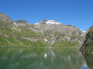
Wilde Kreuzspitze from the south with Wildes See |
||
| height | 3135 m slm | |
| location | South Tyrol ( Italy ) | |
| Mountains | Zillertal Alps | |
| Coordinates | 46 ° 54 '51 " N , 11 ° 35' 40" E | |
|
|
||
| First ascent | July 30, 1861 Anton von Ruthner with the farmer Perterer from the Burgum valley | |
The Wilde Kreuzspitze ( 3135 m slm ) is a mighty double peak between the Pfitscher valley in the northwest and the Valler valley in the southeast in South Tyrol ( Italy ). It is the main summit of the Fundres Mountains, a subgroup of the Zillertal Alps . The summit cross carries the lower south-east summit ( 3132 m ).
The summit was probably climbed early on by locals, but at least during the state survey of Tyrol . On July 30, 1861, A. v. Ruthner , accompanied by farmers Perterer as a mountain guide , the summit of the northwest through the valley of Burgumer Bach and a now defunct addition to the dip of the two peaks.
Marked paths lead from the northwest from the Sterzinger Hütte ( 2344 m ), from the Brixner Hütte ( 2307 m ) over the Rauhtaljoch and the east ridge and from the south over the Sengesscharte to the summit.
Literature and map
- Dieter Seibert: Light 3000s. The 99 most beautiful tours with a path. Bruckmann Verlag, Munich 2008, ISBN 978-3-7654-5011-2
- Hanspaul Menara : The most beautiful 3000m peaks in South Tyrol. 70 worthwhile alpine tours. Athesia, Bozen 2014, ISBN 978-88-8266-911-9
- Heinrich and W. Klier : Alpine Club Guide Zillertal Alps , Munich 1990, ISBN 3-7633-1201-3
- Alpine Club Map 1: 50,000, sheet 31/3, Brenner Mountains
Web links
Individual evidence
- ^ Anthon von Ruthner: From Tyrol. Mountain and glacier trips in the Austrian high Alps. New series , Vienna 1869, p. 55 ff.

