Wolf thorn
| Wolf thorn | ||
|---|---|---|
|
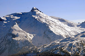
The wolf thorn from the northwest |
||
| height |
2776 m slm 2774 m above sea level A. |
|
| location | Tyrol , Austria and South Tyrol , Italy | |
| Mountains | Zillertal Alps | |
| Dominance | 3.7 km → Kraxentrager | |
| Notch height | 226 m | |
| Coordinates | 46 ° 59 '3 " N , 11 ° 32' 16" E | |
|
|
||
| rock | Lime marble | |
| Age of the rock | law | |
The Wolfendorn is a 2776 m (according to other information also 2774 m ) high mountain in the Zillertal Alps .
Location and surroundings
The Wolfendorn is located in the Tux ridge of the Zillertal Alps between the Wipptal and the Brenner in the west, the Griesberg valley in the north and Pfitsch in the southeast. Since it represents the highest elevation in the immediate vicinity, it rises up quite freely and dominantly. The borders between the Italian South Tyrol and the Austrian North Tyrol and between the communities of Brenner , Gries and Pfitsch run over its summit .
Climbs
The Wolfendorn is accessible from different sides by marked climbs and is easily accessible. Paths lead up from the Brenner , from Brennerbad via the Einzianhütte and the Flatschspitze , from Pfitsch or from the Landshut Europahütte .
etymology
In Atlas Tyrolensis 1770 the Wolfendorn seems Norn as on. Egon Kühebacher therefore leads the name back to a pre-Roman * norr meaning "rough rock, mountain". The reinterpretation from norn to -dorn probably took place in the 19th century. The addition Wolfen- probably comes from the Wolfn homestead ( Brennerwolf ) on the Brenner below.
literature
- Egon Kühebacher : The place names of South Tyrol and their history. The historically grown names of the mountain ranges, summit groups and individual peaks of South Tyrol. Athesia, Bozen 2000, ISBN 88-8266-018-4 , pp. 197 and 334.
- Hanspaul Menara : The most beautiful 2000s in South Tyrol . Athesia, Bozen 2012, ISBN 978-88-8266-830-3 , pp. 106-107

