District of Cuxhaven
| coat of arms | Germany map |
|---|---|

|

Coordinates: 53 ° 37 ' N , 8 ° 49' E |
| Basic data | |
| State : | Lower Saxony |
| Administrative headquarters : | Cuxhaven |
| Area : | 2,057.78 km 2 |
| Residents: | 198,038 (Dec. 31, 2019) |
| Population density : | 96 inhabitants per km 2 |
| License plate : | CUX |
| Circle key : | 03 3 52 |
| NUTS : | DE932 |
| Circle structure: | 29 municipalities |
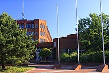
| Address of the district administration: |
Vincent-Lübeck-Strasse 2 27474 Cuxhaven |
| Website : | |
| District Administrator : | Kai-Uwe Bielefeld ( independent ) |
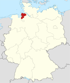
| Location of the district of Cuxhaven in Lower Saxony | |
The district of Cuxhaven is measured on its surface, one of the largest counties in Lower Saxony and one of the largest in Germany. Due to its location on the North Sea , it is the northernmost district in Lower Saxony. With a population density of around 97 inhabitants per square kilometer, the district is below half the national average.
geography
location
Its location in relation to the rest of Germany is characterized as a peripheral location, which is reinforced by the natural borders in the Elbe and Weser estuaries to the neighboring areas.
In this remote area, the district town of Cuxhaven is once again the mathematically furthest place from all other points in the district. The district belongs to both the north-west and Hamburg metropolitan regions , with the old district of Hadeln and the city of Cuxhaven closer to Hamburg , the old district of Wesermünde tends towards Bremerhaven / Bremen , among other things due to the direct motorway connection A 27 .
structure
Communities
(Residents on December 31, 2019)
- Beverstedt (13,545)
- Cuxhaven , district town , large independent city (48,164)
- Geestland , city, independent municipality [seat: Langen ] (30.847)
- Hagen in Bremen (10,947)
- Loxstedt (16,311)
- Schiffdorf (14,339)
- Wurster North Sea Coast [Headquarters: Dorum ] (17,095)
Joint municipalities with their member municipalities * Seat of the joint municipality administration
- 1. Joint municipality Börde Lamstedt (6018)
- Armstorf (652)
- Hollnseth (868)
- Lamstedt * (3314)
- Middle Near (627)
- Stinstedt (557)
- 2. Samtgemeinde Hemmoor (13,903)
- Hechthausen (3453)
- Hemmoor , City * (8663)
- East (1787)
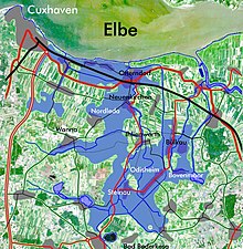
- 3. Joint municipality of Land Hadeln (26,869)
- Belum (812)
- Bülkau (866)
- Cadenberg (4199)
- Ihlienworth (1524)
- Neuenkirchen (1303)
- Neuhaus (Oste) , Flecken (1114)
- North Leda (1053)
- Oberndorf (1352)
- Odisheim (473)
- Easter break (489)
- Otterndorf , City * (7311)
- Steinau (825)
- Wanna (2228)
- Wingst (3320)
Former parishes
The following list contains all former municipalities that have belonged to the district of Cuxhaven since 1977 with the dates of their incorporations.
Neighboring areas
In the area where the Weser flows into the North Sea , the area of the independent seaside town of Bremerhaven ( State of Bremen ) protrudes into the district. The coastline runs in a northerly direction to Cuxhaven, where the district of Cuxhaven borders on the island of Neuwerk, which belongs to Hamburg . From there, the Elbe forms a natural border in an easterly direction up to the border with the district of Stade . Further neighboring districts are the districts of Rotenburg (Wümme) , Osterholz and - west of the Weser - Wesermarsch .
Soil conditions and geology
The subsoil in the area of the district is essentially formed by the moraines and meltwater deposits of the Saale Ice Age , the penultimate glaciation period of the Pleistocene . These form the sandy ridges of the Geest with their typical boulders made of granite and gneiss , such as the north-south mountain ranges of the Wingst and Westerberg , as well as the Hohen Lieth ( Wurster Heide ). The terminal moraines from the last glaciation ( Vistula Ice Age ) did not reach the area. Therefore, the terrain here is much gentler and flatter than z. B. in " Holstein Switzerland ".
Apart from small, relocated sediment residues from the Tertiary and Elster Ice Age "Lauenburg clay", older rocks can only be found at Hemmoor : the white "writing chalk" from the geological formation of chalk . These are the same layers that also form the famous chalk cliffs on Rügen . Until the Hemmoor plant was closed, these rocks were mined to produce Portland cement .
At the beginning of the Holocene , the melting of the glaciers caused a significant rise in sea levels. The lowlands near the coast were flooded; in the valleys in the interior, as the lowlands of Geeste , Lune and Drepte , formed due to the simultaneously rising water table the first fens .
In the Hadler Bay and in the mouth of the Weser, extensive mud flats formed . Every time the mudflats were washed over, the suspended matter carried in the lake water fell out and gradually settled in slightly raised marbles or plateaus. From these sandy silt banks, today's "highlanders", the marches Land Hadeln , Land Wursten and Landwürden were formed . The lower reaches of today's rivers Medem and Oste developed from tidal creeks in the watt.
In the peripheral areas to the Geest, which were cut off from the open sea by the Marren, only brackish water and river marshes formed, today's "Sietländer" (from Low German: siet = low), later also fens .
In lowlands with particularly unfavorable drainage conditions, raised bogs such as Ahlenmoor , Langes Moor , Hymenmoor and Königsmoor (moor) , with peat thicknesses of two to six meters, in places even up to eight meters, were formed. It was only through modern cultivation and drainage that the growth of the bog was stopped. The peat mosses were initially displaced by heather and dwarf shrubs, then by pipe grass and birch trees . In the Ahlenmoor in particular, efforts are now being made to rewet and renaturate the moorland.
Apart from other areas on the German North Sea coast, a similar connection of landscapes as diverse as mudflats, marshes, moor and geest can only be found in the Wash on the coast of Lincolnshire and Norfolk (Great Britain).
The location at the mouth of the Elbe and towards the North Sea entails the risk that large parts of the district, which is often only a little above sea level, would be flooded in the event of a dike breach during a storm surge . A possible scenario for Land Hadeln is described in the article Glameyer-Stack .
Urban catchment areas
The rural district of Cuxhaven consists of the old district of Hadeln, which is more oriented towards Hamburg, and the old district of Wesermünde, which is more oriented towards Bremerhaven and Bremen. In order to take this different orientation into account, it is part of both the Hamburg metropolitan region and the Northwest metropolitan region .
Historical and institutional catchment areas
In terms of historical development, the district of Cuxhaven largely belongs to the former territory of Bremen-Verden , which extended over the Elbe-Weser triangle . In addition to the district of Cuxhaven, this includes today's districts of Osterholz , Rotenburg (Wümme) , Stade and Verden . Many catchment areas of ecclesiastical, cultural, societal or social institutions such as the Chamber of Commerce, Protestant church district , landscape association and others are still based on the borders of this historical area. The territory of Bremen-Verden later formed a continuity with the Landdrostei Stade and the administrative district of Stade . The latter disappeared in 1978 in the enlarged administrative district of Lüneburg, which had also no longer existed in 2004 . Historically, the city of Cuxhaven belonged to Hamburg, while the state of Hadeln formed an independent area. Both ended up being absorbed in the old administrative district of Stade.
history
- For the history of the region before 1866 → see also: History of Hadeln and Sausages
- For the history of the region after 1885 → see also: History of the district of Cuxhaven
The district of Cuxhaven was formed in 1977 from the formerly independent city of Cuxhaven and the districts of Land Hadeln and Wesermünde .
Administrative reforms
Local reforms have taken place in the district in recent years. Further reforms are planned. This led to the merger of the combined municipalities of Hadeln and Sietland. In 2011, the integrated municipality of Beverstedt was converted into a single municipality, and in 2014 the integrated municipality of Hagen was transformed into a single municipality. In 2015, the merger of the combined community of Bederkesa with the city of Langen to form the city of Geestland and the merger of the combined community of Land Wursten with the community of Nordholz to form the unitary community of Wurster Nordseeküste were implemented. In 2016, the merger of the municipalities Am Dobrock and Land Hadeln and the merger of Geversdorf and Cadenberge were completed.
Population development
|
|
(as of December 31st)

|
religion
Traditionally, the area of today's Cuxhaven district is evangelical-Lutheran . The congregations belong to the Evangelical Lutheran Regional Church of Hanover . Especially after the war, large Catholic parishes have formed, which belong to the diocese of Hildesheim , due to the influx of many expellees, guest workers from southern Europe and repatriates from east-central and eastern Europe . Both large Christian churches are subject to restructuring processes as a result of leaving the church. Furthermore live in the district area u. a. Muslims , members of free churches and Jehovah's Witnesses .
politics
District council
| Parties and constituencies | Percent 2016 |
Seats 2016 |
Percent 2011 |
Seats 2011 |
Percent 2006 |
Seats 2006 |
|
|---|---|---|---|---|---|---|---|
| CDU | Christian Democratic Union of Germany | 39.1 | 23 | 39.7 | 23 | 46.2 | 29 |
| SPD | Social Democratic Party of Germany | 34.7 | 20th | 38.1 | 22nd | 37.9 | 24 |
| Green | Alliance 90 / The Greens | 8.5 | 5 | 10.9 | 6th | 5.6 | 3 |
| AfD | Alternative for Germany | 8.2 | 5 | - | - | - | - |
| FDP | Free Democratic Party | 2.9 | 2 | 2.3 | 2 | 5.6 | 3 |
| left | The left | 2.6 | 2 | 2.2 | 1 | - | - |
| FW | Free voters | 2.5 | 1 | 4.1 | 3 | - | - |
| total | 100 | 58 | 100 | 58 | 100 | 62 | |
| Turnout in percent | 55.8 | 53.6 | 51.0 | ||||
The district administrator is the 59th voting member of the district council. At its first meeting, the district council elected Jörg-Andreas Sagemühl (CDU) as chairman of the district assembly. His deputies are Gerhard Tienken (SPD) and Marianne Peus (Greens).
District administrators
- 1977–1991: Martin Steffens (CDU)
- 1991-2004: Martin Döscher (CDU)
- 2004 - to date: Kai-Uwe Bielefeld (independent)
coat of arms
On June 11, 1979, the district of Cuxhaven was granted permission to use the municipal coat of arms. The coat of arms takes on motifs from those of the previous circles: the bishop Nikolaus from the country Hadeln , the shield base from Wesermünde .
|
Blazon : The coat of arms of the district of Cuxhaven is ingoldover ofredandsilver wavy shared sign foottheHoly Bishop Nicholas, ingreen, silbergerändertemregalia, with silvershoesand silvercrookwhose crookedness in a green four-leafRoseends, the righthandofblessingraised, with silver hair andnatural flesh color. Justification of the coat of arms: Its undulating divided shield base points to the marshes on the Elbe and Weser estuaries protected by dikes. The holy bishop Nikolaus, patron saint of boatmen and coastal residents, has been in the Cuxhaven district since the 13th century. |
flag
The coat of arms is used in the circular flag : The flag of the district of Cuxhaven shows the colors green and white with the coat of arms, which is arranged in the middle of the flag.
Partnerships
The district maintains the following partnerships:
-
 Wiesen (Pfitsch) , South Tyrol (Italy)
 -
 Parchim district , Mecklenburg-Western Pomerania (Germany)
(Source under :)
Culture and sights
Jewish cemeteries
8 Jewish cemeteries are documented for the district of Cuxhaven : in Bederkesa , Beverstedt , Cuxhaven , Dedesdorf-Eidewarden , Hagen im Bremischen , Midlum , Stotel and Wingst . They are cultural monuments worthy of protection - stone witnesses to formerly existing Jewish communities and a lively Jewish community life, often up to the 1930s.
Protected areas
In addition to landscape protection areas and natural monuments, there are 44 designated nature protection areas in the district and town (as of February 2017).
→ See also:
- List of nature reserves in the district of Cuxhaven
- List of landscape protection areas in the district of Cuxhaven
- List of natural monuments in the district of Cuxhaven
- List of protected landscape components in the district of Cuxhaven
societies
- The Landschaftsverband Stade was founded as a registered association to maintain cultural institutions
Economy and Infrastructure
The economic center of the region and the seat of some Lower Saxony institutions (tax office, schools) is not the city of Cuxhaven, but the maritime city of Bremerhaven , which belongs to the state of Bremen .
In the Future Atlas 2016 , the district of Cuxhaven was ranked 343 out of 402 districts, municipal associations and independent cities in Germany and is therefore one of the regions with "future risks".
Agriculture
As has been the case for centuries, the economic basis of the district is still agriculture, even though it has lost much of its importance as a result of the structural change of the last few decades. In 1979 a total of 5167 farms were still operating in the district, in 2001 only 3126, of which 65% were the main occupation. The number of establishments continues to decrease with an upward trend. As a rule, however, the areas that are freed up do not fall fallow, but are usually completely taken over by the remaining courtyards.
Over 70% of the district area is used for agriculture (approx. 140,000 hectares). About 70% of this is grassland and 30% arable land. The grassland areas with forage and cattle husbandry (85% of the farms) dominate in all moor and geest areas, but especially in the Marsch Landwürden and in the Hadelner Sietland . On the Geest, the landscape is also shaped by the extensive forest and wooded areas. Of the 294,000 cattle, around 85,000 are dairy cows. These represent the livelihood of most farmers. Nevertheless, the cattle stocking of 1.53 livestock units per hectare of agricultural land is relatively low and appropriate to the natural conditions. The high-performance animals bred in the district are z. T. marketed worldwide.
Specialized agriculture (around 7% of farms), e.g. B. of different types of cabbage and other vegetables, as well as horticulture and fruit growing (3.3% of the farms), especially apples and cherries, are concentrated in the marshland (especially in the Hadelner highlands). About 4.7% of the farms (with an increasing tendency) are dedicated to the processing of pigs and poultry. A total of 1700 broodmares are registered in the horse breeding associations Wesermünde and Land Hadeln. Due to the breeding results, these clubs enjoy a nationwide reputation.
In 1999 around 10% of employees were still working directly on farms, the majority of them as family workers. The downstream food industry with its slaughterhouses, dairies, processing companies, traders and other services employs a further 13%.
tourism
Tourism is of great importance in the district of Cuxhaven. In particular in the Duhnen , Döse and Sahlenburg districts of Cuxhaven , as well as in the city of Otterndorf , in Bad Bederkesa , and in the sluice ports of Dorum and Wremen , there is a dense tourist infrastructure with hotels of all categories, campsites , restaurants and leisure facilities. For the purpose of tourism advertising, the region uses the art term " Cuxland ", which is not a historical landscape designation.
seaport
The port-associated services in Cuxhaven and in Bremerhaven, which is outside the district area, are also important economic factors. Both seaports are important locations for fishing fleets , cargo ports and rescue cruisers .
Social and educational institutions
Clinics
- Hospital Cuxhaven of Helios AG (formerly city hospital) and the Helios Seehospital Sahlenburg
- Otterndorf: Hospital of the Capio Group (formerly the district hospital)
- Debstedt : Seeparkklinik Debstedt
- Also:
- Osterholz District Hospital in Osterholz-Scharmbeck ( Osterholz district )
- Hadeln district: Bremervörde hospital and the Elbe clinics in Stade
education
- Kreisgymnasium Wesermünde in Bremerhaven-Geestemünde , Humboldtstrasse 12.
- Adult education center in the district of Cuxhaven, based in Langen (Geestland) , Debstedter Straße 5a.
- Adult Education Center Cuxhaven , Abendrothstrasse 16
traffic
shipping
Seafaring has traditionally been of great importance for the region. In Cuxhaven and in Bremerhaven, which is adjacent to the district area, there are seaports that are important factors for the local labor market. Inland navigation on the Hadelner Canal and on the Medem near Otterndorf is of touristic importance .
railroad
The district area was initially only opened up in the south by the Hanover State Railroad with the Bremen – Bremerhaven railway line. It was not until 1881 that the Unterelbesche railway company reached Cuxhaven from Hamburg via Stade.
The second connection to Cuxhaven was created by the Prussian State Railways with the Bremerhaven – Cuxhaven line in 1896; at the same time it took the Bremerhaven-Speckenbüttel-Bederkesa branch line into operation. The Bremerhaven – Bremervörde line followed in 1899.
The Kleinbahn Farge-Wulsdorf GmbH ran parallel to the Unterweser since 1911 and was later called the Niederweserbahn .
The end point of Itzwörden of the Kehdinger Kreisbahn , which has been running from Stade since 1899, was also in what is now the district area.
The railway network of more than 160 km in length has been reduced by over a quarter (46 km):
- 1931: Sandstedt – Wurthfleth – Aschwarden – Farge Klb 15 km
- 1932: Stade – Freiburg – Itzwörden 1 km (meter gauge)
- 1964: Bremerhaven- Wulsdorf Klb-Welle- Lanhausen- Sandstedt 18 km
- 1968: Bremerhaven-Speckenbüttel – Langen – Bederkesa 17 km (today a museum railway )
The Cuxhaven tram operated on a military railway only ran to the Döse spa district for one month in 1914. The city of Langen was also served by the Bremerhaven tram from 1919 to 1958.
Today the railways Bremen - Bremerhaven - Cuxhaven ( railway line Bremen - Bremerhaven and " Nordseebahn "), Bremerhaven - Bremervörde - Hamburg ( railway line Bremerhaven - Buxtehude of EVB ) and Hamburg - Stade - Cuxhaven (" Niederelbebahn "), as well as the Bremerhaven – Bederkesa railway line operated by the district itself as a public railway infrastructure company .
Streets
The federal motorway A 27 and the federal highways B 6 , B 71 , B 73 , B 437 and B 495 run through the district . The preferred variant of the planned A 20 federal motorway runs through the southern district area.
Air traffic
The Cuxhaven-Nordholz Airport , which is mainly used by the military, is located in Nordholz . This is the largest military airfield in Germany, but is also to be expanded for private air traffic. In addition, the runway is officially designated as an emergency runway for NASA's space shuttle.
License Plate
On July 1, 1956, the independent city of Cuxhaven was assigned the distinguishing mark CUX when the license plates that are still valid today were introduced . With the founding of the district of Cuxhaven in 1977, this was taken over for the entire district and thus also replaced the previous labels WEM ( Wesermünde ) and OTT ( Land Hadeln , district town of Otterndorf ). It is still issued in the district of Cuxhaven to this day.
literature
- Erich von Lehe: History of the country sausages. With a contribution by Werner Haarnagel. Bremerhaven 1973.
- Rudolf Lembcke (Ed.): District Land Hadeln. History and present. Otterndorf 1976.
- Hans Jürgen Hansen, Klaus Rohmeyer: Coastal district of Cuxhaven. Urbes Verlag, Graefelfing before Munich, 1983.
- Rudolf Lembcke: 100 years of circles at the Elbe and Weser estuaries 1885–1985. The district of Cuxhaven and its legal predecessors. Otterndorf 1985.
Web links
- Website of the district of Cuxhaven
- Literature from and about the district of Cuxhaven in the catalog of the German National Library
Individual evidence
- ↑ State Office for Statistics Lower Saxony, LSN-Online regional database, Table 12411: Update of the population, as of December 31, 2019 ( help ).
- ↑ State Office for Statistics Lower Saxony, LSN-Online regional database, Table 12411: Update of the population, as of December 31, 2019 ( help ).
- ↑ Population figures . (No longer available online.) In: Website State Office for Statistics Lower Saxony (LSN). Archived from the original on April 20, 2019 ; accessed on September 11, 2019 .
- ↑ Overall result of the district election on September 11, 2016. In: Website Zweckverband Kommunale Datenverarbeitung Oldenburg (KDO). Retrieved February 5, 2017.
- ↑ Overall result of the district election on September 11, 2011. In: Website Zweckverband Kommunale Datenverarbeitung Oldenburg (KDO). Retrieved February 5, 2017.
- ↑ a b Erich Dieter Lindner, Günter Olzog (Ed.): The German districts - coat of arms, history, structure . Günter Olzog Verlag, Munich 1986, ISBN 3-7892-7278-7 , p. 157 .
- ^ Main statute of the district of Cuxhaven of December 11, 1996 in the version of the fourth amendment statute of February 24, 2004. § 2; Coat of arms, flag and official seal; Paragraph 1. Retrieved May 9, 2009 (PDF; 22 kB).
- ↑ Heiko Völker: St. Nicholas in the land of Hadeln. How Saint Nicholas got into the coat of arms of the district of Cuxhaven . In: Men from Morgenstern , Heimatbund an Elbe and Weser estuary e. V. (Ed.): Niederdeutsches Heimatblatt . No. 791 . Nordsee-Zeitung GmbH, Bremerhaven November 2015, p. 2–3 ( digitized version [PDF; 1.5 MB ; accessed on September 10, 2019]).
- ^ Main statute of the district of Cuxhaven of December 11, 1996 in the version of the fourth amendment statute of February 24, 2004. § 2; Coat of arms, flag and official seal; Paragraph 2. Retrieved May 9, 2009 (PDF; 22 kB).
- ^ The district of Cuxhaven - figures, data, facts on the district area. In: Website of the district of Cuxhaven. June 30, 2018, accessed September 11, 2019 .
- ↑ LANDKREIS CUXHAVEN. In: Overview of all projects for the documentation of Jewish grave inscriptions in the area of the Federal Republic of Germany ; here: Lower Saxony. Editor: Tobias Kostial. List according to the current administrative structure / REGIERUNGSBEZIRK LÜNEBURG.
- ↑ Future Atlas 2016. (No longer available online.) In: prognos.com. Archived from the original on October 2, 2017 ; accessed on March 23, 2018 .
- ↑ List of infrastructure companies that require approval in accordance with Section 6 AEG. (XLSX; 52 kB) (No longer available online.) In: Website Eisenbahn-Bundesamt. January 19, 2017, archived from the original on March 5, 2017 ; Retrieved March 5, 2017 .


