North Leda
| coat of arms | Germany map | |
|---|---|---|

|
Coordinates: 53 ° 46 ′ N , 8 ° 50 ′ E |
|
| Basic data | ||
| State : | Lower Saxony | |
| County : | Cuxhaven | |
| Joint municipality : | Land Hadeln | |
| Height : | 0 m above sea level NHN | |
| Area : | 21.29 km 2 | |
| Residents: | 1053 (Dec. 31, 2019) | |
| Population density : | 49 inhabitants per km 2 | |
| Postal code : | 21765 | |
| Area code : | 04758 | |
| License plate : | CUX | |
| Community key : | 03 3 52 041 | |
| Community structure: | 8 districts | |
| Address of the municipal administration: |
Otterndorfer Strasse 11 21765 Nordleda |
|
| Website : | ||
| Mayor : | Eugen Boehm ( CDU ) | |
| Location of the municipality of Nordleda in the district of Cuxhaven | ||
Nordleda ( Low German De Lee ) is a municipality in the state of Hadeln in the Lower Saxony district of Cuxhaven . She is a founding member of the Land Hadeln municipality .
geography
location
Nordleda is located in the Lower Elbe region .
The proximity to the Elbe estuary and the North Sea bring with it the risk that in the event of a dike breach during a storm surge, a maximum of 1 m above sea level. Large parts of the municipality located at NHN will be flooded. One possible scenario is described in the article Glameyer Stack .
The Wilster has its source in Nordleda, which absorbs numerous weather conditions up to its confluence with the Medem . The place also has extensive agricultural areas and the Aßbütteler Moor nature reserve .
Community structure
Nordleda consists of the following districts:
- Fresenhörne
- Herring coop
- Kampen
- Middle part
- New way
- Overweather
- End of Easter
- Westerende
Neighboring communities
|
Lüdingworth (City of Cuxhaven) |
Lüdingworth (City of Cuxhaven ) |
|

|
Neuenkirchen | |
| Wanna | Ihlienworth |
(Source:)
history
First mention
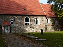
Nordleda was first mentioned in a document in 1312, but is older because the church dedicated to St. Nicholas was built around 1200.
Population development
|
|
¹ census of June 6th
² census of May 27th
³ each December 31st

|
politics
Municipal council
The council of the municipality of Nordleda consists of ten councilors. This is the specified number for the member municipality of an integrated municipality with a population between 1001 and 2000 inhabitants. The council members are elected for a five-year term by local elections. The current term of office began on November 1, 2016 and ends on October 31, 2021.
The honorary mayor is also entitled to vote and sit on the council.
The last local elections resulted in the following distribution of seats immediately after the election:
| Local election | CDU | SPD | Green | FDP | total |
|---|---|---|---|---|---|
| 11th September 2016 | 7 (58.97%) |
3 (28.67%) |
1 (9.51%) |
0 (2.83%) |
11 seats |
| September 11, 2011 | 6 (56.22%) |
4 (36.31%) |
1 (7.45%) |
- | 11 seats |
The turnout in the 2016 local elections was 57.14%, above the Lower Saxony average of 55.5%. In 2011, the turnout was 53.69%.
mayor
The council elected council member Eugen Böhm (CDU) as honorary mayor for the current electoral term. His deputies are Uwe Blohm (CDU) and Uwe Haase (SPD).
coat of arms
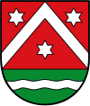
The municipal coat of arms was adopted in 1938 by the Council of the Municipality Nordleda.
| Blazon : "In red over a green shield base coveredwith a silver wavy bar ,a silver rafter , accompanied by three silver stars (2: 1)." | |
| Justification for the coat of arms: The river visible in the green base of the shield is intended to give an indication of the development of the Nordleda community. The first settlements there arose on the natural waterway of the old Lee (Leh). The rafter with the three stars in the upper part of the coat of arms is the Lappesche coat of arms. In old chronicles the Lappes are mentioned as the first and most respected clan of Northern Leda, who were extremely involved in the settlement. In 1342 a knight Konrad Lappe had the patronage of the St. Nicolai Church in Nordleda. A Wölke Lappe fell off Nordleda after the fall of Ritzebuettel in 1395. |
Culture and sights
Buildings
- St. Nicolai Church
- The pumping station on Otterndorfer Strasse
- Hadler Legends Trail: The legends from Land Hadeln are presented on 32 stations on a cycle path
Economy and Infrastructure
traffic
Nordleda is not of great importance for traffic. There is no trunk road through the community. The national road 118 through the town and connects Langen with Wanna , New churches and Cuxhaven .
Personalities
Sons and daughters of the church
- Elisabeth Juliane Maria Pape (1814–1890), writer and local poet
- Heinrich Rüther (1866–1954), Lutheran clergyman and local researcher
- Eduard Rüther (1871–1941), historian and high school teacher
- Jürgen Tern (1909–1975), journalist, publicist and political commentator
- Werner Schröder (1924–2019), theologian, regional bishop of the district of East Friesland
- Uwe Biester (* 1948), local politician and member of the Lower Saxony state parliament
People connected to the community
- Samuel Christian Pape (1774–1817), writer, poet and Protestant theologian
- Ernst Röver (1857–1923), organ builder
- Elisabeth Rühmkorf (1895–1989), teacher, local poet and writer
- Hanns-Christoph Becker von Sothen (1916–1980), Ambassador, he was buried in the Nordleda cemetery
- Chris Trautmann (* 1964), translator and writer
Myths and legends
- The ghost fair in Northern Leda
- The magic book
- The black skirt
- The white maiden in camping
- The Hexenhof in Nordleda
- Latten Tamm
- Fresenhörn
literature
- Th. A. Schröter: The Imsumer and the Nordleda baptismal font and their fate . In: Men from Morgenstern, Heimatbund an Elbe and Weser estuary e. V. (Ed.): Niederdeutsches Heimatblatt . No. 20/21 . Nordsee-Zeitung , Bremerhaven 1951, p. 1–2 ( digitized version [PDF; 4.2 MB ; accessed on August 8, 2020]).
- Heiko Völker, Fritz Hörmann a. a .: Chronicle of the municipality of Nordleda . Ed .: Volksbank Cuxhaven-Hadeln eG. Nordleda December 1995 (242 pages, special edition).
- Eberhard Michael Iba (Ed.): Hake Betken siene Duven. The saga of the Elbe and Weser estuaries (= special publications by the men from Morgenstern , Heimatbund at the Elbe and Weser estuaries . Volume 16 ). 3. Edition. Men from Morgenstern Verlag, Bremerhaven 1999, ISBN 3-931771-16-4 .
Web links
Individual evidence
- ↑ State Office for Statistics Lower Saxony, LSN-Online regional database, Table 12411: Update of the population, as of December 31, 2019 ( help ).
- ↑ Overview map of the Cuxhaven district. In: cuxland-gis.landkreis-cuxhaven.de. November 2016, accessed January 22, 2020 .
- ^ Ulrich Schubert: Register of local authorities in Germany 1900 - Hadeln district. Information from December 1, 1910. In: gemeindeververzeichnis.de. January 5, 2020, accessed January 22, 2020 .
- ^ A b c Michael Rademacher: German administrative history from the unification of the empire in 1871 to the reunification in 1990. Landkreis Land Hadeln ( see under: No. 40 ). (Online material for the dissertation, Osnabrück 2006).
- ↑ a b Statistisches Bundesamt Wiesbaden (ed.): Official municipality register for the Federal Republic of Germany - 1957 edition (population and territorial status September 25, 1956, for Saarland December 31, 1956) . W. Kohlhammer, Stuttgart 1958, p. 188 ( digitized version ).
- ↑ a b Federal Statistical Office (ed.): Historical municipality register for the Federal Republic of Germany. Name, border and key number changes in municipalities, counties and administrative districts from May 27, 1970 to December 31, 1982 . W. Kohlhammer, Stuttgart / Mainz 1983, ISBN 3-17-003263-1 , p. 243 .
- ↑ Lower Saxony State Administration Office (ed.): Municipal directory for Lower Saxony . Municipalities and municipality-free areas. Self-published, Hanover January 1, 1973, p. 44 ( digital version [PDF; 21.3 MB ; accessed on January 22, 2020] Land Hadeln).
- ↑ a b c d e f g h i j community directory - archive - regional structure - annual editions - Lower Saxony. (All politically independent municipalities in EXCEL format). In: Destatis website. Federal Statistical Office, accessed on January 22, 2020 .
- ^ Lower Saxony Municipal Constitutional Law (NKomVG); Section 46 - Number of Deputies. In: Lower Saxony Regulations Information System (NI-VORIS). December 17, 2010, accessed March 1, 2018 .
- ↑ a b Overall result of the local council election Nordleda 2016. In: Website Zweckverband Kommunale Datenverarbeitung Oldenburg (KDO). September 16, 2016, accessed March 1, 2018 .
- ↑ a b Overall results of the municipal council elections Nordleda 2011. In: Website Zweckverband Kommunale Datenverarbeitung Oldenburg (KDO). September 11, 2011, accessed January 22, 2020 .
- ↑ The CDU gets the most votes nationwide. In: Website Norddeutscher Rundfunk . September 12, 2016, accessed February 13, 2017 .
- ^ City council and mayor of Nordleda. In: Ratsinfosystem der Samtgemeinde Land Hadeln. Retrieved March 1, 2018 .
- ↑ a b Heiko Völker, Fritz Hörmann u. a .: Chronicle of the municipality of Nordleda . Ed .: Volksbank Cuxhaven-Hadeln eG. Nordleda December 1995, p. 45 (242 p., Special print).
- ^ Rudolf Lembcke: Land Hadeln district. Past and present . Ed .: District of Hadeln. Buchdruckerei Günter Hottendorff, Otterndorf 1976, p. 52 (coat of arms).
- ↑ The coat of arms of Nordleda. In: Website of the municipality of Land Hadeln. Retrieved November 10, 2017 .


