
Joint municipality of Land Hadeln
| coat of arms | Germany map | |
|---|---|---|

|
Coordinates: 53 ° 48 ' N , 8 ° 54' E |
|
| Basic data | ||
| Existing period: | 2016– | |
| State : | Lower Saxony | |
| County : | Cuxhaven | |
| Area : | 406.57 km 2 | |
| Residents: | 26,869 (Dec. 31, 2019) | |
| Population density : | 66 inhabitants per km 2 | |
| License plate : | CUX | |
| Association key : | 03 3 52 5411 | |
| Association structure: | 14 municipalities | |
| Association administration address : |
Marktstrasse 21 21762 Otterndorf |
|
| Website : | ||
| Mayor of the municipality : | Harald Zahrte ( independent ) | |
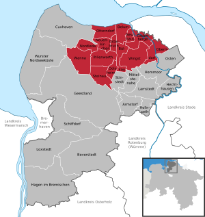
| Location of the municipality of Land Hadeln in the district of Cuxhaven | ||
  |
||

The joint municipality of Land Hadeln is a joint municipality in the district of Cuxhaven in Lower Saxony . 14 municipalities have come together in it to carry out their administrative business. The administrative seat of the combined community is the city of Otterndorf , in Cadenberge and Ihlienworth there are branch offices with citizens' offices, in Neuenkirchen, Nordleda and Wanna there are community offices.
geography
location
The area of the integrated municipality is on the Niederelbe side of the district of Cuxhaven in Lower Saxony . It is part of the historical and cultural area of Land Hadeln in the Elbe-Weser triangle and comprises roughly the middle part of the "Hadler Highland" between the present-day urban area of the city of Cuxhaven and the confluence of the Oste into the Elbe . The northern border of the integrated community forms the confluence with the Elbe. In the south, in the Sietland, the moorland lakes near Bad Bederkesa (Dahlemer, Halemer and Bederkesaer See). The former western border to the urban area of Cuxhaven has grown irregularly and not historically since the previously independent Hadler communities Altenbruch and Lüdingworth were incorporated into Cuxhaven. The landscape is characterized by the fertile marshland and the coastal location. The most important body of water in the area is the Medem , which flows into the Elbe together with the Hadler Canal near Otterndorf .
The difficult drainage of the southern Sietland takes place via the Emmelke , the Alte Aue and the Gösche, which unite at Ihlienworth to form the Medem, as well as a large number of landscape-shaping weather, receiving waters and ditches. Without the Hadelner Canal, built in 1853, and the Otterndorf pumping station , there would be regular flooding due to the topographical location of up to two meters below sea level. Only in the west of the Samtgemeinde, in the Wannaer Geest and in Ahlen, is there a slightly elevated and sandy subsoil. The largely cultivated Ahlenmoor stretches in the triangle between Wanna, Ihlienworth and Steinau.
structure
The integrated municipality, whose administrative seat and center is the city of Otterndorf, consists of the following member municipalities:
history


Hadolaun (Hadeln) is already mentioned in the Saxon Chronicle of Widukind von Corvey (around 950) as the landing place of the Saxons.
The country of Hadeln looks back on a long period of politically independent development. It was not until the Kingdom of Hanover was annexed by Prussia after the Austro-Prussian War in 1866 that the special status of the Land of Hadeln ended.
In the Middle Ages, the Hadelner Sietland (from Low German: siet = "low") was summarized under the name "Five Parishes". (Up to the 14th century there was a chapel in Süderleda in addition to the churches in Wanna, Ihlienworth, Steinau and Odisheim.) Together with the Hadler Hochland ("Seven Parishes") and the residents of the town of Otterndorf, the Sietland formed one of the three "Stands" of the Hadler self-government (see Warningsacker ). From 1388 to around 1484, however, the Sietland was under the Bremen Bailiwick of Bederkesa. In place of the parish Süderleda was at this time Wester-Ihlienworth (next to Oster-Ihlienworth) as the fifth parish that had gained population through the medieval Holler colonization. Then the five parishes came back to the land of Hadeln.
For the history of the region before 1866 → see also: History of Hadeln and Sausages .
Incorporations
The Sietland community was from 1970/72 to 2011 the amalgamation of the four communities Ihlienworth, Odisheim, Steinau and Wanna. On January 1, 2011, the previous joint municipalities Sietland and Hadeln were merged to form the new joint municipality Land Hadeln. 15,321 inhabitants lived in an area of 228.48 km² (as of December 31, 2015).
A second new formation of the municipality of Land Hadeln took place on November 1st, 2016, when the municipality of Am Dobrock merged with the municipality of Land Hadeln. The administrative seat of this new integrated municipality Land Hadeln is again in Otterndorf.
Population development
| year | 1987 | 1992 | 1997 | 2002 | 2007 | 2008 | 2009 | 2010 | 2011 | 2012 | 2013 | 2014 | 2015 | 2016 | 2017 | 2018 |
|---|---|---|---|---|---|---|---|---|---|---|---|---|---|---|---|---|
| Residents | 14,810 | 15,100 | 15,477 | 16,048 | 15,848 | 15,639 | 15,639 | 15,644 | 15,467 | 15,319 | 15,286 | 15,237 | 15,321 | 27.303 | 27,064 | 26,830 |
(as of December 31st)

|
Population development of the integrated municipalities
→ See: Samtgemeinde Hadeln (1987–2010)
→ See: Samtgemeinde Sietland (1987–2010)
→ See: Samtgemeinde Am Dobrock (1987–2015)
politics
Joint council
The council of the municipality of Land Hadeln consists of 40 councilors and councilors. This is the specified number for a municipality with a population between 40,000 and 50,000 inhabitants. The council members are elected for a five-year term by local elections. The current term of office began on November 1, 2016 and ends on October 31, 2021.
The full-time mayor of the joint municipality is also entitled to vote in the council of the joint municipality.
The last local election on September 11, 2016 resulted in the following:
| Political party | Proportional votes | Number of seats |
|---|---|---|
| CDU | 43.07% | 17th |
| SPD | 40.61% | 16 |
| GREEN | 6.04% | 2 |
| FDP | 4.64% | 2 |
| AfD | 2.95% | 1 |
| Free voters | 1.53% | 1 |
| Individual applicant Kunkel | 1.13% | 1 |
The turnout in the 2016 local elections was 62.82%, above the Lower Saxony average of 55.5%.
The council chairman is Eugen Böhm (CDU).
Joint mayor of the municipality
The full-time mayor of the municipality is Harald Zahrte (independent). In the mayoral election on September 11, 2016, he was re-elected (as the only applicant) with 83.9% of the vote.
coat of arms
 |
Blazon : “ Split ; in front nine times divided by black and gold , covered with a green diamond wreath turned diagonally to the right ; back in green with black sign foot of Bishop Nicholas in silver choir dress , under green goldgerändertem chasuble with gold shoes , green gold-rimmed Mitra , with silver crook whose crookedness in a golden fünfblätterigen Rose ends, the right hand to bless charged with golden hair and natural flesh color . " |
| Justification of the coat of arms: The diamond wreath from the community coat of arms of the Saxon house indicates the rule that the Lauenburg dukes exercised over the land of Hadeln until it died out in 1689. St. Bishop Nikolaus, patron saint of boatmen and coastal residents, has appeared in the seals of the Hadeln country since the 13th century. |
Partnerships
-
 Krasnosnamensk Raion in Kaliningrad Oblast , Russia , since 1995
 -
 Witkowo , Poland, since 1995
(Source under :)
Culture and sights


Buildings
- Evangelical Lutheran St. Johannis d.T. Church in Steinau
- St. Wilhadi Church in Ihlienworth in the 13th century Romanesque style
- St. Nicolai Church in Nordleda from the 11th century
- Farmhouses in Nordleda
- St. Marien Church in Neuenkirchen from the 14th century
- Houses in half-timbered architecture in Neuenkirchen
- St. Petri Church in Osterbruch
- Kranichhaus in Otterndorf from 1585, rebuilt around 1760
- St. George's Church in Westerwanna from the 14th century
- Hadler legend trail
Museums
- Local museum Wanna
Public facilities
General
- Hadler House and Citizens' Office in Otterndorf, Marktstrasse 21
- Otterndorf City Library, Wallstrasse 12
- School library in the school Am Dobrock, upper row 11
- Land Hadeln volunteer fire brigade with local fire brigades in all member communities
schools
- Elementary School Otterndorf, Cuxhavener Straße 16
- Elementary school Neuenkirchen, Dorfstrasse 52
- Sietland Primary School in Ihlienworth, Rosenstrasse 9
- Wanna primary school, Landesstrasse 119
- Primary school at Wingster Wald, Hasenbeckallee 11
- Elementary school Cadenberge, Heideweg 12a
- Elementary school Neuhaus an der Oste, school place 2
- Wittmackschule - school for learning assistance in Otterndorf, Cuxhavener Straße 16,
- Johann Heinrich Voss School, secondary school and secondary school in Otterndorf, Schulstrasse 2
- High school in Otterndorf, Schulstrasse 2
- Warstade high school, Bürgermeister-Grube-Strasse 1
- School Am Dobrock (Oberschule), upper row 11
- Cadenberge Vocational Schools, Im Park 4
- Vocational training center Cadenberge Stade gGmbH, Töpferstrasse 4
- Adult education center in the district of Cuxhaven in Otterndorf, Sophienweg 1
Personalities
Sons and daughters of the integrated church
- Hinrich Wilhelm Kopf (1893–1961), District Administrator of the Hadeln district 1928–1932 and first Prime Minister of Lower Saxony, born in Neuenkirchen
- Hermann Rauhe (* 1930), musicologist and music teacher , born in Wanna
Persons who are connected to the entire community
- Johann Heinrich Voss (1751–1826), poet and translator of famous classics
- Helmut Salzinger (1935–1993), writer, editor and small publisher
Web links
Individual evidence
- ↑ State Office for Statistics Lower Saxony, LSN-Online regional database, Table 12411: Update of the population, as of December 31, 2019 ( help ).
- ^ Widukind von Corvey: Res gestae Saxonicae . Ed .: Ekkehart Rotter and Bernd Schneidmüller. Reclam, Stuttgart 1981, p. 22 .
- ↑ Lower Saxony State Chancellery (Ed.): Ordinance on the merger of the combined communities of Hadeln and Sietland . Lower Saxony Law and Ordinance Gazette (Nds. GVBl.). No. 10/2010 . Hanover April 7, 2010, p. 162 ( digitized version ( memento from March 21, 2016 in the Internet Archive ) [PDF; 141 kB ; accessed on September 21, 2019] p. 2).
- ↑ Lower Saxony State Chancellery (Ed.): Ordinance on the merger of the integrated communities Am Dobrock and Land Hadeln . Lower Saxony Law and Ordinance Gazette (Nds. GVBl.). No. 19/2015 . Hanover November 10, 2015, p. 317 ( digitized version ( memento from July 5, 2019 in the Internet Archive ) [PDF; 464 kB ; accessed on September 21, 2019] p. 19).
- ↑ Information on the merger. In: Website of the municipality of Land Hadeln. Retrieved October 30, 2016 .
- ↑ Population figures . (No longer available online.) In: Website of the State Office for Statistics Lower Saxony (LSN). Archived from the original on April 20, 2019 ; accessed on September 21, 2019 .
- ↑ a b c Samtgemeinde Land Hadeln - Samtgemeinderatswahl 2016. In: Website Zweckverband Kommunale Datenverarbeitung Oldenburg (KDO). September 11, 2016, accessed September 21, 2019 .
- ^ Lower Saxony Municipal Constitutional Law (NKomVG); Section 46 - Number of Deputies. In: Internet site for the Lower Saxony Regulation Information System (NI-VORIS). December 17, 2010, accessed September 21, 2019 .
- ↑ The CDU gets the most votes nationwide. In: NDR website . September 12, 2016. Retrieved February 17, 2017 .
- ↑ Election of the joint mayor of the joint municipality of Land Hadeln. In: NDR website. Retrieved September 14, 2016 .
- ^ Rudolf Lembcke: Land Hadeln district. Past and present . Ed .: District of Hadeln. Buchdruckerei Günter Hottendorff, Otterndorf 1976, p. 5 (coat of arms).
- ↑ Heiko Völker: St. Nicholas in the land of Hadeln. How Saint Nicholas got into the coat of arms of the district of Cuxhaven . In: Men from Morgenstern , Heimatbund an Elbe and Weser estuary e. V. (Ed.): Niederdeutsches Heimatblatt . No. 791 . Nordsee-Zeitung GmbH, Bremerhaven November 2015, p. 2–3 ( digitized version [PDF; 1.5 MB ; accessed on September 10, 2019]).
- ↑ Entry about the sponsorships and partnerships. In: Website of the city of Otterndorf. Retrieved April 12, 2019 .