
Belum
| coat of arms | Germany map | |
|---|---|---|

|
Coordinates: 53 ° 49 ' N , 9 ° 0' E |
|
| Basic data | ||
| State : | Lower Saxony | |
| County : | Cuxhaven | |
| Joint municipality : | Land Hadeln | |
| Height : | 0 m above sea level NHN | |
| Area : | 25.72 km 2 | |
| Residents: | 812 (Dec. 31, 2019) | |
| Population density : | 32 inhabitants per km 2 | |
| Postal code : | 21785 | |
| Area code : | 04752 | |
| License plate : | CUX | |
| Community key : | 03 3 52 004 | |
| Community structure: | 7 districts | |
| Address of the municipal administration: |
Marktstrasse 21, 21762 Otterndorf |
|
| Website : | ||
| Mayor : | Matthias Peter ( Citizen List Belum Kehdingbruch [BBK] ) | |
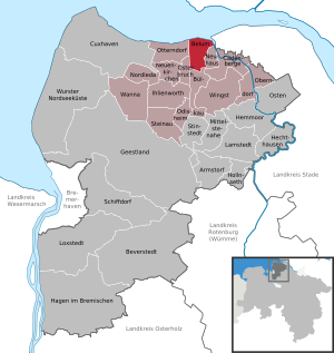
| Location of the municipality of Belum in the district of Cuxhaven | ||
  |
||


The community of Belum ( Belen in Low German ) is a member of the community association Samtgemeinde Land Hadeln in the Lower Saxony district of Cuxhaven .
geography
location
The municipality of Belum is located directly on the estuary and the Niederelbe in the district of Cuxhaven and belongs to the combined municipality of Land Hadeln .
Today's Oste flows into a canal a little further east into the Elbe, since an eastern barrier was built in 1964 and the oxbow lake was closed by two broad dams, so the Ostesee was created at the eastern barrier.
Community structure
- Bahrdorf
- Belum (main town)
- Belumerdeich
- Hollanderhof
- Kehdingbruch
- Königswisch
- Western village
Neighboring communities
| Otterndorf |
.svg)
|
Neuhaus |
| Easter break | Bülkau |
(Source:)
history
The name
Since Belum is located in the north at the old estuary on the Elbe, the name can be traced back to the geographical location. The "column in the country" - the tributary to the Elbe was called Beilheim and Belem and over the centuries it became today's Belum.
First mention
Belum was first mentioned on March 23, 1377 in a contract between the parish of Belum and the council of the Hanseatic City of Hamburg. This contract was about the intention not to rob each other anymore. (Other sources speak of 1150.)
The St. Vitus Church was built around the year 1230; it was renovated at the turn of the century in 2000 at great financial expense.
middle Ages
Belum became known in the Middle Ages for its small port, located on the Belumer Wettern. As the main hub for wood in the region, the place came to some prosperity. Two markets a year have survived, the one-week St. Vitus market and the much longer wood market.
Belumer Schanze
Among the main defenses of the Thirty Years' War which belonged Belumer ski jump at the mouth of the Oste . During the Second World War there was an air defense position of the 8.8 cm flak, which fought the Allied bomber formations in the direction of Hamburg with three kills. After the war was between Belum and Kehdingbruch HAWK missiles position of NATO established. In the course of the location of air defense in the Bundeswehr, it was dismantled in the 1990s. Today only a street name and a bus stop remind of the "Schanze".
 Belumer Schanze
 The Belumer Schanze area today
 Coat of arms of the former HAWK rocket position Belum
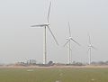 Former HAWK rocket position, current wind farm


.jpg)
Beacon in Belum

The lighthouses in Belum are also part of the lighting of the Elbe and the North Sea. Across from the Ostebank, a sandbank in the Elbe near the mouth of the East, a lighthouse similar to the Balje lighthouse was built in 1904 . This white tower, based on a round brown brick base, with a railing platform and a conical brown roof, was the first to be operated with petroleum light. Converted to liquid gas in 1927, they had installed a 250 mm belt light as optics. In contrast to the lighthouse in Balje, the tower in Belum was switched off in 1982 and demolished a year later. Today's so-called "leading light line" consists of the Belum upper fire, a thin, red and white striped 44 meter high tower with an inverted conical roof, as well as the Belum lower fire, 1,340 meters away, at the same time the Otterndorf lower fire, which is built the same but only 25 meters high is. The lighthouses can be seen 18 nautical miles.
Incorporations
As part of the regional reform in Lower Saxony , which took place on July 1, 1972, the previously independent municipality of Kehdingbruch was incorporated into the municipality of Belum.
Population development
|
|
1 155 fires
2 in 152 houses (parish Belum total)
3 census results on June 6, including Kehdingbruch
four census results on May 27, including Kehdingbruch
5 at December 31

|
politics
Municipal council
The Belum parish council consists of eight councilors and councilors. This is the specified number for the member municipality of an integrated municipality with a population between 501 and 1000 inhabitants. The council members are elected for a five-year term by local elections. The current term of office began on November 1, 2016 and ends on October 31, 2021.
The mayor is also entitled to vote and sit on the council.
The last local election on September 11, 2016 resulted in the following:
| Political party | Proportional votes | Number of seats |
|---|---|---|
| Belum / Kehdingbruch Citizens' List (BBK) | 69.95% | 6th |
| CDU | 22.99% | 2 |
| Green | 7.04% | 1 |
The turnout in the 2016 local elections was 67.14%, above the Lower Saxony average of 55.5%.
mayor
The local council elected councilor Matthias Peter (BBK) as honorary mayor for the current electoral term. His deputies are Hartwig Meyer (BBK) and Joachim Schlichting (BBK).
coat of arms
|
|
Blazon : "In blue a golden winged Mercury hat over the part of a golden entrenchment as a shield base ." |
| Justification of the coat of arms: The Merkurius hat is a symbol of trade and refers to the Belumer Vitimarkt, which was once important for the entire surrounding area. The entrenchment is reminiscent of the Belumer Schanze , which played a role especially in the wars of the 17th century. |
Culture and sights
Architectural monuments
Regular events
- Belum shooting festival: second weekend in June
- Schützenfest Kehdingbruch: first weekend in June
- Autumn festival: third weekend in September
- Fire brigade ball of the volunteer fire brigade Belum: last Saturday in October
Clubs and organizations
|
|
(Source:)
Personalities
Sons and daughters of the church
- Johann Friedrich Goebel (1869–1927), librarian, born in Kehdingbruch
- Albert Rodegerdts (1898–1973), district leader of the NSDAP in Cuxhaven and Uelzen
People connected to the community
- Georg Wilhelm Wilhelmy (1748–1806), organ builder who initially worked in Northern Hesse and then from 1781 to 1806 in Stade, from 1783 to 1786 he created the organ for the local St. Vitus Church
- Ernst Cammann (1888–1978), farmer and politician (DNVP, CDU), in 1918 he took over his father's farm in Belum
- Rowan West (* 1953), organ builder from Altenahr, in 2001 he created a new building behind the historic prospectus on the organ of the local St. Vitus Church
Myths and legends
- The compliant assistant
literature
- Willi Klenck: home book of the former district Neuhaus an der Oste . 1957.
- Eberhard Michael Iba (Ed.): Hake Betken siene Duven. The saga of the Elbe and Weser estuaries (= special publications by the men from Morgenstern , Heimatbund at the Elbe and Weser estuaries . Volume 16 ). 3. Edition. Men from Morgenstern Verlag, Bremerhaven 1999, ISBN 3-931771-16-4 .
Web links
Individual evidence
- ↑ State Office for Statistics Lower Saxony, LSN-Online regional database, Table 12411: Update of the population, as of December 31, 2019 ( help ).
- ↑ Overview map of the Cuxhaven district. In: cuxland-gis.landkreis-cuxhaven.de. November 2016, accessed March 24, 2020 .
- ↑ a b c Federal Statistical Office (ed.): Historical municipality directory for the Federal Republic of Germany. Name, border and key number changes in municipalities, counties and administrative districts from May 27, 1970 to December 31, 1982 . W. Kohlhammer, Stuttgart / Mainz 1983, ISBN 3-17-003263-1 , p. 243 .
- ^ CH Jansen: Statistical Handbook of the Kingdom of Hanover (= Statistical Handbooks for the Kingdom of Hanover ). Helwing'sche Hofbuchhandlung, Celle 1824, p. 46 ( digitized version in Google Book Search [accessed October 17, 2019]).
- ↑ Friedrich W. Harseim, C. Schlüter: Statistical Handbook for the Kingdom of Hanover (= Statistical Handbooks for the Kingdom of Hanover ). Schlüter'sche Hofbuchdruckerei, Hanover 1848, p. 135–136 ( digitized in Google Book Search [accessed October 17, 2019]).
- ^ Ulrich Schubert: Community directory Germany 1900 - Neuhaus an der Oste district. Information from December 1, 1910. In: gemeindeververzeichnis.de. January 5, 2020, accessed March 24, 2020 .
- ^ A b c Michael Rademacher: German administrative history from the unification of the empire in 1871 to the reunification in 1990. Landkreis Land Hadeln ( see under: No. 7 ). (Online material for the dissertation, Osnabrück 2006).
- ↑ a b Statistisches Bundesamt Wiesbaden (ed.): Official municipality register for the Federal Republic of Germany - 1957 edition (population and territorial status September 25, 1956, for Saarland December 31, 1956) . W. Kohlhammer, Stuttgart 1958, p. 187 ( digitized version ).
- ↑ Lower Saxony State Administration Office (ed.): Municipal directory for Lower Saxony . Municipalities and municipality-free areas. Self-published, Hanover January 1, 1973, p. 44 , Land Hadeln ( digitized [PDF; 21.3 MB ; accessed on August 28, 2019]).
- ^ Municipalities in Germany by area and population. (XLSX; 895 kB) See under: Lower Saxony, No. 1793 . In: Destatis website. Federal Statistical Office, December 31, 1975, accessed on October 17, 2019 .
- ↑ a b c d e f g municipality directory - archive - regional structure - annual editions - Lower Saxony. (All politically independent municipalities in EXCEL format). In: Destatis website. Federal Statistical Office, accessed on October 17, 2019 .
- ^ Municipalities in Germany by area, inhabitants and postcode. (XLS; 3.1 MB) See under: Lower Saxony, No. 1823 . In: Destatis website. Federal Statistical Office, December 31, 2000, accessed on October 16, 2019 .
- ^ Municipalities in Germany by area, population and postcode. (XLS; 4.4 MB) See under: Lower Saxony, No. 1980 . In: Destatis website. Federal Statistical Office, December 31, 2015, accessed on October 16, 2019 .
- ↑ a b c The parish council of Belum. In: Ratsinfosystem der Samtgemeinde Land Hadeln. Retrieved June 8, 2019 .
- ^ Lower Saxony Municipal Constitutional Law (NKomVG); Section 46 - Number of Deputies. In: Lower Saxony Regulations Information System (NI-VORIS). December 17, 2010, accessed June 8, 2019 .
- ↑ a b Municipality of Belum - overall results of the municipal council election 2016. In: Website Zweckverband Kommunale Datenverarbeitung Oldenburg (KDO). September 11, 2016, accessed February 16, 2017 .
- ↑ The CDU gets the most votes nationwide. In: Website Norddeutscher Rundfunk . September 12, 2016, accessed February 16, 2017 .
- ^ Rudolf Lembcke: Land Hadeln district. Past and present . Ed .: District of Hadeln. Buchdruckerei Günter Hottendorff, Otterndorf 1976, p. 17 (part of the coat of arms).
- ^ History and coat of arms of Belum. In: Website of the municipality of Hadeln. Retrieved August 28, 2019 .
- ↑ a b appointment calendar. In: Website Schützenverein Belum from 1897 e. V. Accessed June 8, 2019 .
- ^ Associations and organizations. In: Website of the municipality of Land Hadeln. Retrieved August 28, 2019 .

Armstorf | Belum | Beverstedt | Bülkau | Cadenberge | Cuxhaven | Geestland | Hagen in Bremen | Hechthausen | Hemmoor | Hollnseth | Ihlienworth | Lamstedt | Loxstedt | Near center | Neuenkirchen | Neuhaus | North Leda | Oberndorf | Odisheim | East | Easter break | Otterndorf | Schiffdorf | Steinau | Stinstedt | Wanna | Wingst | Wurster North Sea Coast
Belum | Kehdingbruch | Bahrdorf | Belumerdeich | Hollanderhof | Königswisch | Western village