
Kehdingbruch
|
Kehdingbruch
Kedenbrook ( Low German ) Belum parish
|
||
|---|---|---|
 |
||
| Height : | 0 m above sea level NHN | |
| Area : | 6.58 km² | |
| Residents : | 403 (May 27 1970) | |
| Population density : | 61 inhabitants / km² | |
| Incorporation : | July 1, 1972 | |
| Postal code : | 21785 | |
| Area code : | 04752 | |
Location of Kehdingbruch in Lower Saxony |
||
 Kehdingbruch in the former joint municipality Am Dobrock
|
||


Kehdingbruch ( Low German Kedenbrook ) is an integrated place of the municipality Belum . He is a member of the community association Samtgemeinde Land Hadeln in the Lower Saxony district of Cuxhaven .
geography
Geographical location
The formerly independent community of Kehdingbruch is located south of Belum, east of Otterndorf and west of Neuhaus, directly on the estuary and the Lower Elbe .
Today's Oste flows into a canal a little further east into the Elbe, since an eastern barrier was built in 1964 and the oxbow lake was closed by two broad dams, so the Ostesee was created at the eastern barrier.
history
The name
The word Kehding meant something like embankment, and the name Bruch can best be described by the word wetland. So the "diked wet land" could be translated as meaning.
First mention
On the occasion of the bell casting for the chapel, today's district was first mentioned in the church records in 1404, 88 years later in 1492 the citizens of Kehdingbruch donated a new church. Construction of today's St. Jürgen's Church began in 1744.
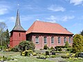 St. Jürgen Church
 Organ of the St. Jürgen Church


independence
Kehdingbruch was an independent municipality until 1972, when the residents could decide whether they wanted to join Belum or Neuhaus (Oste). Why they decided in favor of Belum can be explained in the different proportions between Neuhaus and Belum. The distance to both places is so great that sports and shooting clubs etc. could not unite, and the two volunteer fire brigades were also retained. The border between the two districts is the railway line.
Incorporations
On July 1, 1972, the Kehdingbruch community was incorporated into the Belum community.
Population development
| year | 1824 | 1848 | 1910 | 1925 | 1933 | 1939 | 1950 | 1961 | 1970 |
|---|---|---|---|---|---|---|---|---|---|
| Residents | - 1 | 475 2 | 351 | 382 | 363 | 333 | 671 | 413 3 | 403 4 |
| source |
1 75 fireplaces
2 in 80 houses
3 census results from June 6th
4 census results from May 27th
politics
City council and mayor
Kehdingbruch is represented at the local level by the Belum Municipality Council.
coat of arms
The design of the municipal coat of arms of Kehdingbruch comes from the heraldist and coat of arms painter Gustav Völker , who designed around 25 coats of arms in the district of Cuxhaven. The approval of the coat of arms was given in 1954 by the district president in Stade.
|
|
Blazon : "In red two diagonally crossed silver gable boards , which end in horses' heads turned outwards, in front of two silver clover leaves sitting on a silver handle." |
| Justification of the coat of arms: The horse heads are a symbol of Lower Saxony. The shamrocks indicate pasture farming. |
flag
The colors white and red, arranged one above the other, serve as the flag base. In the middle of the flag is the coat of arms of the town.
Culture and sights
Buildings

- The old forge
- Blacksmiths have always been an integral part of a village, including in Kehdingbruch. A building of this craftsmanship still exists today, even if only the name "Antik Schmiede" remains today. In 1717 Claus Follmer's forge was first mentioned in a document; it remained in the family until the last village blacksmith, Richard Stüven, died in 1988 and a descendant of Follmer. At the beginning of the 20th century, the fields of work in wagon construction and repair as well as blacksmith could be seen, but the increasing mechanization after the Second World War changed the work fundamentally. Like many village blacksmiths in the area, Richard Stüven also stopped working in the 1960s, but since he occasionally took on smaller jobs, his workshop was retained. When the forge was listed as a historical monument in 1986, it represented a large and almost completely preserved collection of old historical tools and equipment. The idea for a forge museum could not be realized due to lack of money, and so private individuals bought the forge. The new owners, the van Gemmeren family, restored the forge and also built an old half-timbered barn from Opole next to the forge in 1996 to have more space for their workshop. The old blacksmith tools and machines have been preserved, although today antique furniture is restored in the forge and the barn and new furniture is built according to old templates.
Architectural monuments
→ See: List of architectural monuments in Kehdingbruch
Regular events
- Schützenfest Kehdingbruch: 1st Sunday in June
Personalities
Sons and daughters of the place
- Johann Friedrich Goebel (1869–1927), librarian
Web links
Individual evidence
- ↑ a b Federal Statistical Office (ed.): Official municipality register for the Federal Republic of Germany . Final results according to the September 13, 1950 census. Volume 33 . W. Kohlhammer Verlag, Stuttgart / Cologne August 1952, p. 49 , col. 1 ( digital version [PDF; 26.4 MB ; accessed on June 8, 2019] Landkreis Land Hadeln, p. 58).
- ↑ a b c d Federal Statistical Office (Hrsg.): Historical municipality register for the Federal Republic of Germany. Name, border and key number changes in municipalities, counties and administrative districts from May 27, 1970 to December 31, 1982 . W. Kohlhammer, Stuttgart / Mainz 1983, ISBN 3-17-003263-1 , p. 243 .
- ^ Friedrich Jansen: Statistical Manual of the Kingdom of Hanover (= Statistical Manuals for the Kingdom of Hanover ). Helwing'sche Hofbuchhandlung, Celle 1824, p. 328 ( digitized in Google Book Search [accessed October 16, 2019]).
- ↑ Friedrich W. Harseim, Carl Schlüter: Statistical Manual for the Kingdom of Hanover (= Statistical Manuals for the Kingdom of Hanover ). Schlüter'sche Hofbuchdruckerei, Hanover 1848, p. 137 ( digitized version in Google Book Search [accessed October 16, 2019]).
- ^ Ulrich Schubert: Community directory Germany 1900 - Neuhaus an der Oste district. Information from December 1, 1910. In: gemeindeververzeichnis.de. February 3, 2019, accessed June 8, 2019 .
- ↑ a b c Michael Rademacher: German administrative history from the unification of the empire in 1871 to the reunification in 1990. Landkreis Land Hadeln ( see under: No. 26 ). (Online material for the dissertation, Osnabrück 2006).
- ↑ Landkreis Wesermünde (Ed.): Coat of arms of the Landkreis Wesermünde . Grassé Offset Verlag, Bremerhaven / Wesermünde 1973, ISBN 3-9800318-0-2 .
- ↑ a b c The Basbeck gable ornament . In: Niederelbe-Zeitung (Local) . July 22, 2017, p. 14 .
- ^ Rudolf Lembcke: Land Hadeln district. Past and present . Ed .: District of Hadeln. Buchdruckerei Günter Hottendorff, Otterndorf 1976, p. 38 (coat of arms).
Belum | Kehdingbruch | Bahrdorf | Belumerdeich | Hollanderhof | Königswisch | Western village