
Odisheim
| coat of arms | Germany map | |
|---|---|---|

|
Coordinates: 53 ° 42 ' N , 8 ° 56' E |
|
| Basic data | ||
| State : | Lower Saxony | |
| County : | Cuxhaven | |
| Joint municipality : | Land Hadeln | |
| Height : | −1 m above sea level NHN | |
| Area : | 13.5 km 2 | |
| Residents: | 473 (Dec. 31, 2019) | |
| Population density : | 35 inhabitants per km 2 | |
| Postal code : | 21775 | |
| Area code : | 04756 | |
| License plate : | CUX | |
| Community key : | 03 3 52 043 | |
| Community structure: | 5 districts | |
| Address of the municipal administration: |
Marktstrasse 21, 21762 Otterndorf |
|
| Website : | ||
| Mayor : | Stefan Skowron ( CDU ) | |
| Location of the municipality of Odisheim in the district of Cuxhaven | ||
  |
||

Odisheim ( Low German Godshem ) is a municipality in the combined municipality of Land Hadeln in the Lower Saxony district of Cuxhaven .
geography

location
Odisheim is in the Niederelbe region . The proximity to the Elbe estuary and the North Sea entail the risk that in the event of a dike breach in a storm surge, large parts of the municipality area, which is a maximum of 2 m above sea level, but also below sea level, would be flooded. One possible scenario is described in the article Glameyer Stack .
Community structure (districts)
- At sea
- triangle
- Church Village
- Northern part
- Southern part
Neighboring communities
| Ihlienworth | Bülkau | |
.svg)
|
||
| Steinau | Stinstedt |
history

The name of the place probably goes back to pre-Christian and thus pre-Carolingian times and probably means Odin's home . The first documentary mention, however, did not take place until 1325. From 1388 to about 1484 the parish of Odisheim belonged to the Bailiwick of Bederkesa , together with the parishes of Steinau, Oster- and Wester-Ihlienworth and Wanna (the "Five Parishes") . In documents of the 16th century, the name form Odeßhem is found next to the "Christianized" form Gadeshem ("Gottsheim").
Population development
|
|
¹ 138 fireplaces
² in 153 houses
³ as of December 31st
religion
78% of the residents of Odisheim are Protestant, only 3% Catholic. The Evangelical Lutheran parish of Odisheim with the St. Jobst Church belongs to the Cuxhaven-Hadeln parish of the Hanover regional church . The Holßel parish of the Evangelical Reformed Church is responsible for the Reformed , while the parish of St. Cross in Otterndorf , which belongs to the Bremerhaven dean's office in the Hildesheim diocese, is responsible for the Catholics .
politics
Municipal council
The council of the municipality Odisheim consists of six councilors and councilors. This is the specified number for the member municipality of an integrated municipality with up to 500 inhabitants. The council members are elected for a five-year term by local elections. The current term of office began on November 1, 2016 and ends on October 31, 2021.
The mayor is also entitled to vote in the council.
The last local election on September 11, 2016 resulted in the following:
| Political party | Proportional votes | Number of seats |
|---|---|---|
| CDU | 100.00% | 7th |
The turnout in the 2016 local elections was 67.66%, above the Lower Saxony average of 55.5%.
mayor
The municipal council elected councilor Stefan Skowron (CDU) as honorary mayor for the current electoral term.
coat of arms
|
|
Blazon : “ Divided twiceby a ribbon diced blue and white , the field of which is blue at the top and white at the bottom; above: two silver arrowhead leaves in blue; in the middle: the rolled ribbon; below: a blue arrow herb leaf in silver. " |
| Justification of the coat of arms: The arrowhead leaves point to the plant that occurs frequently there and at the same time to the constant struggle of the Sietlanders with the water in their deep inland area. The diced ribbon is borrowed from the coat of arms of the noble family Kule , which owned the tithe in Odisheim in the 14th century. |
Culture and sights

Buildings
- St. Jobst Church
- Rectory
- Hadler Sagenweg: The sagas of the Hadeln country are presented at 32 stations on the Hadler Sagenweg
Architectural monuments
museum
The Heimatstuben: Historical household and agricultural items are exhibited here.
Picture gallery

Aerial view

The Hadler Canal on Schöpferwerkstrasse

The pumping station for the goslings, the pumps are freed of flotsam
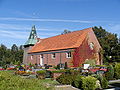
The Church of Odisheim, consecrated to St. Jobst


traffic
The place is close to the Hadelner Canal and on Landesstraße 144.
Personalities
People connected to the community
- Georg Rieper (1909–1982), entrepreneur and inventor
- Helmut Salzinger (1935–1993), writer, editor and publisher
Myths and legends
- God's reward
- The witches' meal
- Hook your duvet
Web links
Individual evidence
- ↑ State Office for Statistics Lower Saxony, LSN-Online regional database, Table 12411: Update of the population, as of December 31, 2019 ( help ).
- ^ Friedrich Jansen: Statistical Manual of the Kingdom of Hanover (= Statistical Manuals for the Kingdom of Hanover ). Helwing'sche Hofbuchhandlung, Celle 1824, p. 454 ( digitized version in the Google book search).
- ↑ Friedrich W. Harseim, C. Schlüter: Statistical Handbook for the Kingdom of Hanover (= Statistical Handbooks for the Kingdom of Hanover ). Schlüter'sche Hofbuchdruckerei, Hanover 1848, p. 157 ( digitized version in the Google book search).
- ^ Ulrich Schubert: Register of local authorities in Germany 1900 - Hadeln district. Information from December 1, 1910. In: gemeindeververzeichnis.de. February 3, 2019, accessed October 9, 2019 .
- ^ A b c Michael Rademacher: German administrative history from the unification of the empire in 1871 to the reunification in 1990. Landkreis Land Hadeln ( see under: No. 42 ). (Online material for the dissertation, Osnabrück 2006).
- ^ Federal Statistical Office (ed.): Official municipality directory for the Federal Republic of Germany . Final results according to the September 13, 1950 census. Volume 33 . W. Kohlhammer Verlag, Stuttgart / Cologne August 1952, p. 49 , col. 1 ( digital version [PDF; 26.4 MB ; accessed on October 9, 2019] Landkreis Land Hadeln, p. 58).
- ↑ Lower Saxony State Administration Office (ed.): Municipal directory for Lower Saxony . Municipalities and municipality-free areas. Self-published, Hanover January 1, 1973, p. 44 ( digital version [PDF; 21.3 MB ; accessed on October 9, 2019] Landkreis Land Hadeln).
- ^ Municipalities in Germany by area and population. (XLSX; 895 kB) See under: No. 1806 . In: Destatis website. Federal Statistical Office, December 31, 1975, accessed on October 9, 2019 .
- ↑ a b c d e f g h i j k Community directory - archive - regional structure - annual editions. (All politically independent municipalities in EXCEL format). In: Destatis website. Federal Statistical Office, accessed on October 16, 2019 .
- ^ Municipalities in Germany by area, inhabitants and postcode. (XLS; 3.1 MB) See under: No. 1881 . In: Destatis website. Federal Statistical Office, December 31, 2000, accessed on October 9, 2019 .
- ^ Municipalities in Germany by area, population and postcode. (XLS; 4.9 MB) See under: No. 2034 . In: Destatis website. Federal Statistical Office, December 31, 2013, accessed on October 9, 2019 .
- ^ Municipalities in Germany by area, population and postcode. (XLS; 4.4 MB) See under: No. 2001 . In: Destatis website. Federal Statistical Office, December 31, 2015, accessed on October 9, 2019 .
- ^ Municipalities in Germany according to area, population and population density. (XLSX; 3.3 MB) See under: No. 1969 . In: Destatis website. Federal Statistical Office, December 31, 2016, accessed on October 9, 2019 .
- ↑ 2011 census
- ^ Lower Saxony Municipal Constitutional Law (NKomVG); Section 46 - Number of Deputies. In: Lower Saxony Regulations Information System (NI-VORIS). December 17, 2010, accessed July 12, 2019 .
- ↑ a b Municipality of Odisheim - overall results of the municipal council election 2016. In: Website Zweckverband Kommunale Datenverarbeitung Oldenburg (KDO). September 11, 2016, accessed February 14, 2017 .
- ↑ The CDU gets the most votes nationwide. In: Website Norddeutscher Rundfunk . September 12, 2016. Retrieved February 12, 2017 .
- ↑ Skowron goes into the second term in Odisheim. In: Website Cuxhavener Nachrichten / Niederelbe-Zeitung. November 14, 2016, accessed July 12, 2019 .
- ^ Rudolf Lembcke: Land Hadeln district. Past and present . Ed .: District of Hadeln. Buchdruckerei Günter Hottendorff, Otterndorf 1976, p. 54 (coat of arms).
- ↑ Eberhard Michael Iba (Ed.): Hake Betken siene Duven. The saga of the Elbe and Weser estuaries (= special publications by the men from Morgenstern , Heimatbund at the Elbe and Weser estuaries . Volume 16 ). 3. Edition. Men from Morgenstern Verlag, Bremerhaven 1999, ISBN 3-931771-16-4 .

Armstorf | Belum | Beverstedt | Bülkau | Cadenberge | Cuxhaven | Geestland | Hagen in Bremen | Hechthausen | Hemmoor | Hollnseth | Ihlienworth | Lamstedt | Loxstedt | Near center | Neuenkirchen | Neuhaus | North Leda | Oberndorf | Odisheim | East | Easter break | Otterndorf | Schiffdorf | Steinau | Stinstedt | Wanna | Wingst | Wurster North Sea Coast