
Stinstedt
| coat of arms | Germany map | |
|---|---|---|

|
Coordinates: 53 ° 40 ′ N , 8 ° 58 ′ E |
|
| Basic data | ||
| State : | Lower Saxony | |
| County : | Cuxhaven | |
| Joint municipality : | Börde Lamstedt | |
| Height : | 7 m above sea level NHN | |
| Area : | 30.1 km 2 | |
| Residents: | 557 (Dec. 31, 2019) | |
| Population density : | 19 inhabitants per km 2 | |
| Postal code : | 21772 | |
| Area code : | 04756 | |
| License plate : | CUX | |
| Community key : | 03 3 52 052 | |
| Community structure: | 4 districts | |
| Address of the municipal administration: |
Schützenstrasse 20 21769 Lamstedt |
|
| Website : | ||
| Mayor : | Klaus Steffens ( Stinstedt list of citizens ) | |
| Location of the community of Stinstedt in the district of Cuxhaven | ||
  |
||


The community of Stinstedt ( Low German Stinst ) is a member of the community association Samtgemeinde Börde Lamstedt in the district of Cuxhaven in Lower Saxony . In addition to the main town of Stinstedt, the municipality also includes the towns of St. Joost , Neubachenbruch and Moorausmoor.
geography
The renatured Stinstedter See lies southwest of the place.
history
Sankt Joost was a holy Jodokus consecrated chapel , which in 1367 was first mentioned and until the Reformation, the area attracted many pilgrims. It was canceled in 1541.
Incorporations
On July 1, 1972, the communities Moorausmoor and Neubachenbruch were incorporated.
Population development
| year | 1961 | 1970 | 1987 | 1992 | 1997 | 2002 | 2007 | 2008 | 2009 | 2010 | 2011 | 2012 | 2013 | 2014 | 2015 | 2016 |
|---|---|---|---|---|---|---|---|---|---|---|---|---|---|---|---|---|
| Residents | 823 | 742 | 640 | 615 | 603 | 560 | 567 | 546 | 535 | 549 | 569 | 564 | 562 | 561 | 558 | 574 |
(1961 on June 6th, 1970 on May 27th, each census results including Moorausmoor and Neubachenbruch; from 1987 on each December 31st)

|
politics
Municipal council
The council of the municipality of Stinstedt consists of nine councilors and councilors. This is the specified number for the member municipality of an integrated municipality with a population between 501 and 1000 inhabitants. The council members are elected for a five-year term by local elections. The current term of office began on November 1, 2016 and ends on October 31, 2021.
The last local election on September 11, 2016 resulted in the following:
| Political party | Proportional votes | Number of seats |
|---|---|---|
| Stinstedt citizens' list | 79.72% | 7th |
| Neubachenbruch voter community | 20.27% | 2 |
The turnout in the 2016 local elections was 75.95%, above the Lower Saxony average of 55.5%.
mayor
The municipal council elected councilor Klaus Steffens (Stinstedt citizens' list) as honorary mayor for the current electoral term.
coat of arms
|
|
Blazon : "In silver the sacred Joost or Jodokus in green pilgrims robe with a red pilgrim's staff in his right hand and a golden Pilgrim shell in his left hand; at his feet on the left a golden aristocratic crown . " |
| Foundation of the coat of arms: In the district of St. Joost there was a pilgrimage chapel, which was much visited until the Reformation and later moved to Stinstedt itself, and which was dedicated to St. Joost. |
Culture and sights
Architectural monuments
Regular events
- Shooting festival on the third weekend in June
Picture gallery

The extinguishing water pond, formerly a sand pit in Stinstedt

The monument of the pilgrimage chapel St. Joost

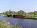
The Randkanal in Stinstedt
The barrage at the end of the edge canal in the Hadelner Canal


Personalities
Sons and daughters of the church
- Christiane Arp (* 1961), journalist
Myths and legends
- Hare weaves
- The chapel of St. Joost
literature
- Udo Theuerkauf: Small local history of the Lamstedt Börde . Ed .: Samtgemeinde Börde Lamstedt. Lamstedt 1997.
Web links
Individual evidence
- ↑ State Office for Statistics Lower Saxony, LSN-Online regional database, Table 12411: Update of the population, as of December 31, 2019 ( help ).
- ↑ a b Federal Statistical Office (ed.): Historical municipality register for the Federal Republic of Germany. Name, border and key number changes in municipalities, counties and administrative districts from May 27, 1970 to December 31, 1982 . W. Kohlhammer, Stuttgart / Mainz 1983, ISBN 3-17-003263-1 , p. 243 .
- ↑ LSKN-Online.
- ^ Lower Saxony Municipal Constitutional Law (NKomVG); Section 46 - Number of Deputies. In: Internet site for the Lower Saxony Regulation Information System (NI-VORIS). December 17, 2010, accessed February 11, 2017.
- ↑ a b Municipality of Stinstedt - overall results of the 2016 municipal council election. In: Website Zweckverband Kommunale Datenverarbeitung Oldenburg (KDO). September 11, 2016, accessed February 18, 2019.
- ↑ The CDU gets the most votes nationwide. In: NDR website. September 12, 2016. Retrieved February 11, 2017 .
- ^ Council of the community of Stinstedt. In: Internet site of the joint municipality Börde Lamstedt. Retrieved February 11, 2017.
- ^ Rudolf Lembcke: Land Hadeln district. Past and present . Ed .: District of Hadeln. Buchdruckerei Günter Hottendorff, Otterndorf 1976, p. 62 (coat of arms).
- ↑ a b Eberhard Michael Iba (Ed.): Hake Betken siene Duven. The saga of the Elbe and Weser estuaries (= special publications by the men from Morgenstern , Heimatbund at the Elbe and Weser estuaries . Volume 16 ). 3. Edition. Men from Morgenstern Verlag, Bremerhaven 1999, ISBN 3-931771-16-4 .

Armstorf | Belum | Beverstedt | Bülkau | Cadenberge | Cuxhaven | Geestland | Hagen in Bremen | Hechthausen | Hemmoor | Hollnseth | Ihlienworth | Lamstedt | Loxstedt | Near center | Neuenkirchen | Neuhaus | North Leda | Oberndorf | Odisheim | East | Easter break | Otterndorf | Schiffdorf | Steinau | Stinstedt | Wanna | Wingst | Wurster North Sea Coast