Stinstedter See
Coordinates: 53 ° 39 ′ 0 ″ N , 8 ° 57 ′ 5 ″ E
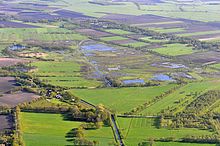
The Stinstedter See is a former Niedermoorsee in the Lower Saxony municipality of Stinstedt in the district of Cuxhaven . It lies between Bad Bederkesa and Hemmoor, southwest of Stinstedt. The area of the former lake is now largely drained and serves as a flood polders .
history
The lake had formed in the Stinstedter lowlands due to backwater at the confluence of the Gösche, Hornbach and Mooraue rivers. At the time of the Kurhannoversche Landesaufnahme in the 18th century, it was around 5 km long and up to 380 m wide and covered an area of around 1 km².
In the 19th century the area of the lake was reduced to about 0.2 km² as a result of drainage and changes in the water system. The new Stinstedter Randkanal emptied into the lake from the east. The Hornbach had been diverted to the moor floodplain, which now formed the outflow from the lake to the Hadelner Canal . The area around the lake was used as grassland .
Further drainage measures were carried out and the water system changed until the 20th century. In the 1950s and 1960s, the area was diked in order to be able to use it as an overflow polder for floods . A pumping station regulates the water level.
The lake silted up completely. The area was now used intensively for agriculture. The still water in the south of the polder was subsequently dredged and used as a fishing pond.
Renaturation
Between 1994 and 2004, the district of Cuxhaven and the nature conservation foundation of the district acquired the land in the polder and thus withdrew it from intensive agricultural use. The 133 hectare area is being renatured through the creation of permanently and periodically flooded areas .
Since 2007 the area has been flooded in the winter months. This results in a large area is to fen develop shallow water area, which for avifauna and flora has a high value.
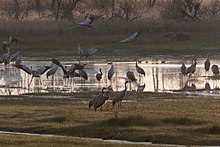
The polder, which is characterized by dammed swamp and water areas with reeds and alder quarries, as well as moist grassland areas , is now an important wetland area . It offers a habitat for numerous water and meadow birds , but also marsh plants such as fever clover and iris . In the meantime, lapwing , curlew , redshank , common snipe and black-tailed godwit can be found as breeding birds . In the winter months it is a resting area for migrating bird species such as geese , swans and ducks , but also cranes .
Tourist use
The polder is surrounded by an approx. 5 km long circular path that can be used as a bicycle or footpath. The circular route is signposted and provided with information boards in several places. There are observation towers in two places , from which the area can be clearly seen.
Web links
- Stinstedter See (PDF; 120 kB)
Individual evidence
- ↑ a b c Stinstedter See (PDF; 120 kB) . Retrieved August 21, 2012.
- ↑ a b Excursion to the Stinstedter See (PDF; 12.7 MB) , Hadler Kurier , October 26, 2011. Accessed on August 21, 2012.
- ↑ a b c Stinstedter Seepolder , joint municipality Börde Lamstedt. Retrieved August 21, 2012.
- ↑ a b Stinstedter See , district of Cuxhaven. Retrieved May 16, 2019.


