
Glameyer stack


The Glameyer-Stack is a deflector platform in the dike section "Altenbrucher Bogen" on the Lower Elbe (river km 713), which is located in the area of the town of Otterndorf in the Müggendorf district. Before it flows into the North Sea, the Lower Elbe curves to the south between the mouth of the East and Cuxhaven , the "Altenbrucher Bogen". The Glameyer Stack plays an important role in the final change of direction of the entire Elbe water before the North Sea .
history
After the Elbe had shifted further and further south in the previous centuries in the estuary area despite all the resistance of the residents and many dyke lines could not be maintained, the waterworker Reinhard Woltman in particular secured the shoreline from the Hamburg - Cuxhaven side in cooperation with the Hadelern so, that the further shift of the Elbe to the south has been stopped until today. The Glameyer Stack was completed in 1802 with a length of 200 m and is an important part of this bank protection. The name can be traced back to the owner of the adjacent land.
charges
The main stress factor is the location on the outer edge, on the so-called impact slope . As a result of the tide , not only does the normal runoff water of the Elbe flow here, but considerably more salt water twice a day from the North Sea into the estuary , mixes with the fresh water of the Elbe and also flows twice a day into the North Sea. This multiple pollution is increased by the highest flow velocity in the entire Lower Elbe at the Glameyer Stack and in front of Cuxhaven. The erosion of the existing uniform fine sand is correspondingly high . This particularly strong attack resulted in a scour over 30 m deep directly in front of the Glameyer Stack in the immediate vicinity of the bank .
Due to the combination of many other unfavorable factors, this section of the dike is rated as a critical point in the dike line between Cuxhaven and Otterndorf : The double burden as a lake and river dike on the rebound slope , the highest flow speed in the Elbe, no protective mudflats , little and constantly eroded front beach, none Protective dyke foreland, extreme water depths in the immediate vicinity of the dyke and, as a result, high swell loads as well as strong and increasing shipping traffic with ever larger ships near the bank are the main stress factors of this bank section and its dyke. The subsoil consists of uniform fine sand and layers of clay and has a weak to medium load-bearing capacity. As a uniform floor, it is particularly sensitive to vibrations ( thixotropy ) when buoyant . This extreme accumulation of risk factors is unique on the German coast: nowhere do such high waves come so close to the dike. The probability of a dike breach in the event of a storm surge is therefore comparatively high.
For these reasons, this area is particularly protected and monitored by various fortifications (concrete stones, surf fence, paved dyke foot, etc.). The wear and tear is high and the structural possibilities of hydraulic engineers are still required today. The structure itself has to be constantly repaired and regular sand pre-flushing maintains the protection of the adjoining revetment against slipping into the Elbe. On the Glameyer stack z. B. 1990 1.4 million DM built to compensate for the changes caused by the deepening of the Elbe during this period. The scouring and dredging have exposed a deeper-lying groundwater level with coarse gravel . Through this aquifer, salt water penetrates much faster and further into the country. The aquifers also transmit the vibrations caused by ship waves under the dike into the land and made dishes clink in the houses near the dike.
The Glameyer-Stack is the main protection of the south bank against the otherwise steadily advancing erosion, which occurs further east in the area Besenhalmer Trift and Otterndorfer Watt due to the increased flow velocity since the last deepening of the Elbe .
Dike breach simulation
A comparison simulation with data from the Anatol storm surge from 1999 and an assumed dike breach of 200 m in length showed that an area of 175 km² would be flooded at least about 40 cm. Depending on the height of the tide, various smaller elevations such as summer dikes, canal dikes and the dam of the Niederelbebahn prevent the water from spreading evenly. This dike breach and flood simulation "only" assumed a water level of + 4.5 m above sea level and thus calculated a maximum flow velocity at the point of the dike failure of 1.4 m / s. The other calculations are based on a maximum flow velocity of 0.5 m / s at a distance of 500 m and a short warning time of less than three hours. But since in Cuxhaven in the storm surge in 1962 , a water level of + 4.95 m above sea level, in 1976, + 4.7 + 5.1 m and even were achieved above sea level, is a stronger and more rapid spread of the water and thus a larger area of damage with higher floods of around 360 km² are very likely.
Flood water / upstream water
In general, it can be said that the brackish water, colored deep gray by earth and mud, will quickly mix with heating oil from half-empty, flooded tanks and with sewage from private sewage treatment plants and septic tanks and manure pits . A surface film of oils and lighter, water-insoluble substances will form. When the water withdraws, this film will cover the flooded areas like a skin. It is therefore irrelevant for a damage calculation whether the water was 10 or 50 cm in a house. All the doors would have been softened, the water and its mixture of dirt would have penetrated the masonry and renovation / drying would be costly and tedious. A significant decrease in the water would not be expected until after the second flood at the earliest, since in a storm surge the first subsequent low water would be above the broken dike foot. As a result, the water pressure would be less noticeable and less water would run into the flooded areas. However, this break would only last a few hours. Depending on the weather, the second flood could have a lower maximum water level, but the existing water pressure would be distributed over the already flooded areas as a second flood wave, reaching and flooding new areas that were spared during the first tidal wave. Since all of the flooded areas are below sea level, it would take up to two weeks for all pumps to pump out the water. It would take years to repair the damage, because the pollution of the soil would make "normal" agriculture impossible. The biological damage would also be very dramatic depending on the time of year, especially since many of the flooded areas are nature reserves .
Stations of the flooding of a "small" 4.5 m storm surge


If the dike were broken, the water would flow from Müggendorf, 1 km away from the dyke, about 2 km south to the embankment, the first major obstacle to inflowing water. The water would split at the embankment. Depending on the existing speed, this dam could hold up the water for a long time. If the dam were to be overcome, however, after a further 2 km the B 73 would be the next obstacle to the spread of the water towards the south. However, there are various small passages that could let the water slowly rise directly behind the embankment and the B73.
To the west, the water would spread over the Westerhofstrom and the Braakstrom (south side of the railway embankment) to Altenbruch . Here it would flow in the Altenbruch Canal to Lüdingworth . Behind Lüdingworth, the water would first spread over the ditches into the low areas as far as Wanna . The relatively small area would then be between 10 and 40 cm deep under water.
Most of the water would flow to the east. There is a little more than 4 km from the dike breach area to the first houses and the hospital in Otterndorf . The water would meet the Medem between the city and the holiday area “See aft Diek” . In the Medem, without weirs or locks, it would flow via Neuenkirchen , about 3.5 km as the crow flies from Otterndorf, to Ihlienworth , about 8 km from Otterndorf.
On the way to Neuenkirchen (Land Hadeln), the meandering Medem at Scholien is the first to encounter the brown weather that leads to Osterbruch . Since the place is around 1.1 m above sea level, the water would meet the water of the outside weather in the southern part of Osterbruch without major flooding, which would only absorb the water after Pedingworth from the Medem and would flood low-lying areas there in the south .
Shortly before Neuenkirchen in the Höden district , the Medem meets the Wilster . This is responsible for the drainage of the area of the village Nordleda , which is about 4 km before the confluence. Ostergehrenstrom, Osterscheidungsstrom, Süderscheidungs and Oberwetter flow from the Wilster. Depending on the water pressure, only the eastern part of northern Leda would be flooded, as the area is between - 60 cm below sea level and + 50 cm above sea level in the town center. In Neuenkirchen the direction of flow of the Uthwetter would be reversed and therefore the southern end would be flooded. In the following Pedingworth the already mentioned outside weather would flood the south of Osterbruch , the Schweinkopf and Nubhusen .
On the way of the Medem to Ihlienworth a little weather and the old Gösche influence in the Medem would be affected. Subsequently, two large drains for the area around Wanna would be flooded with the Emmelke and the Böderwetter . Since Wanna consists of many small and large Wurten , the place would not be flooded directly, however, through these two drainage channels, the triangle with Neuenkirchen and Ihlienworth on the east side and Wanna over Nordleda in the west would be up to 1 m under water.
In Ihlienworth, behind the pumping station, the Medem is distributed in Böderwetter, the Moorwetter in the west, the Große Medemstaderwetter, the Alte Aue and the street dike weather in the south and the Siedenscheidwetter in the east. The Misslacher Wetter and the second natural drainage next to the Alte Aue, the Gösche, go from the Siedenscheid Wetter , which extends to Odisheim . All of these drainage ditches would now flood the area between Ihlienworth, Odisheim and Steinau . The Sietland lies up to one meter below sea level and is bordered to the east and south by the Hadelner Canal . In the west, these drainage ditches would lead the water into the Ahlenmoor , the Flögelner See and the Halemer and Dahlemer See , if these had not already been flooded via the Hadelner Canal.
Despite closures in the area of the Otterndorf pumping station , at the same time as the advance along the Medem, the water would pour between the pumping station and the construction area north of Otterndorf further east into the "Schifffahrtsweg Elbe-Weser", the Hadelner Canal. The Hadelner Canal runs approximately 4 km parallel to the Elbe dike to the east until it changes direction by 90 ° to the south at the Belumer radar tower. The canal keeps this rough south direction for about 14 km before changing direction by 45 ° to the south-west in Odisheim. In the simulation of the storm surge described here with the dike breach at the Glameyer Stack, the second of the three weak points in the dike line between Cuxhaven and Hamburg is not included. In addition to the Glameyer Stack and the Eastern Barrier further east, the lock of the Hadelner Canal is the second weak point, as it is lower than the dykes surrounding it. The dikes were raised from 1998 to 2001, although the state of Lower Saxony did not have sufficient funds for the construction. Therefore the flooding of the following area will depend on the condition of the lock. Therefore, only the minimally flooded area is described here.
According to the simulation, the water in the Hadelner Canal would not flow over the canal dike at the first 90 ° turn of the canal at Belum , but would only flow about 6 km further up to Bülkau . In two easy curves of the canal, like a short time later with the next 45 ° bend after a further 8 km in Odisheim, the canal dikes would give way and the water would flow westward together with the water of the Medem into Sietland. On the east side of the canal, the water would first pour into the southern end of Bülkau and Bülkau-Bovenmoor. This area lies between - 30 cm NN in Bülkau Dorf and Süderende, - 40 to - 60 cm in Bülkau-Lichtenpilz and -Bovenmoor to the lowest point, east of the Opole Geest with - 90 cm. In the east of Bülkau and in the north of Bovenmoor, the Bülkauer Aue would absorb the water and carry it to Neuhaus (Oste) . The flood area would extend over the whole of Oppeln (Wingst) to the Balksee and its moor areas, to the north of Stinstedt and Mittelstenahe , which, however, are above sea level and therefore not directly flooded. Depending on the amount of water, the water would flow back to Neuhaus (Oste) via the Neuhaus-Bülkauer Canal .
In the further course of the Hadelner Canal, the Gösche already described is drained in Odisheim, as the canal divides it here: the northern part via the Medem, the southern part through a pumping station into the canal. In the case of the storm surge assumed here, there would be no drainage, but flooding of the Stinstedter Rand Canal and the Langes Moor area west and south of Stinstedt to Moorausmoor .
In the further course of the Hadelner Canal, approx. 6 km from the last bend, there is another approx. 40 ° turn to the west. Shortly beforehand, the water of the main receiving stream Steinau, the Alte Aue and the effort, small old natural drainage streams, would meet with the waters of the Great Medemstader Wetter coming from Ihlienworth and the Straßdeichwetter that is between - 70 cm to - 20 cm below sea level Land to flood Steinau.
Only another 3 km away, the canal meets the natural and artificial drains, the Lehe and the Flögelner lake drainage , in the further course of which the Halemer and Dahlemer lakes lie. Here adjacent areas would be flooded.
The Bad Bederkesa behind it lies on a ridge and thus only low-lying parts such as areas around Lake Bederkesa would be flooded.
More scenarios
The described flooding with a dike breach in a storm surge of 4.5 m above sea level only includes areas that are below sea level. If the water column is only 20 cm higher, the blue-colored areas in the west would extend to the red motorway from Cuxhaven to Wanna, in the south with dry Geestinseln to Bad Bederkesa. In the east, the water would flow through the Neuhaus-Bülkauer Canal around the Wingst , the wooded Geestrücken and the town of Cadenberge to the north , to the east of which it would flood the area between Neuhaus (Oste), Geversdorf , Oberndorf and Hemmoor .
At a water level of 5.1 m above sea level, the weak points already described in the dike defense would give way and the area in the area of influence of the Oste to Hechthausen would be added to the areas described . The area between Neuhaus (Oste) and Hechthausen was flooded for the last time in 1962 by many dike breaches. Since the eastern barrier is supposed to keep the water out, hardly any money has been invested in the renovation of the eastern dikes in recent years. Complex construction work on the barrage is not planned in the near future, although the height of the barrage is around 80 cm below that of the new dykes.
Glameyer stack danger zone
Due to the proximity of the fairway, the area harbors great potential for danger. For example, the English steamer Kaffraria , whose stern is set up in the dike area of Otterndorf, and the 274-meter-long container freighter Hyundai Discovery , whose power supply completely collapsed in July 2005 and then drove down the Elbe, ran aground in a storm in 1891 . People were not harmed when the ships hit the bottom. The first ship was unloaded on the spot and later sank in the Elbe. The other was towed free after four hours with the help of four tugs and the onset of the tide under the supervision of the rescue cruiser Hermann Helms and the Neuwerk (a multi-purpose ship of the WSA Cuxhaven stationed on Heligoland ).
Climate change
At a congress of the acua alta on the subject of “Climate Impacts and Disaster Control” in Munich in 2005, it was determined that the dikes in Lower Saxony were facing a great potential risk. A rise in mean sea level and an intensification of the westerly wind weather patterns are expected for the German Bight. Intense westerly winds mean that the wind carries larger amounts of water from the Atlantic into the North Sea . These water masses become a danger when the wind turns to northwest or north. Like in a funnel, the water is first pressed against the Schleswig-Holstein coast in a westerly wind . If the wind turns northwest, the Elbe estuary and the Weser estuary are affected. If the wind continues to turn north, as in a hurricane low that pulls over the British Isles in an east / northeast direction, the water is additionally pushed into the entire area of the south coast of the North Sea to the English Channel .
In fact, this means that the tidal flood can be expected to rise by 50 cm by 2100. As a result, the probability of a dike failure is increased by a factor of 5.5. Added to this is the simultaneous intensification of the wind speed of 7%, which means a further increase by a factor of 1.3. In order to counteract these dangers, the dykes would have to be raised by up to 1.5 m, in the case of particularly endangered dike sections, which also include the area of the Glameyer-Stack, even by 1.7 m. In this area, an increase of 1.7 m would result in a major change in the dyke line, as the direct border with the Elbe fairway means that the dike can only be moved inland. The lack of foreland of the dike, the necessary gently sloping dike angle in the endangered area and the two scour lakes in the direct hinterland of the dike would cause the planning and construction time and the associated costs to increase disproportionately. A second dike defense line, consisting of renewed and repaired summer dykes and other elevations such as railway embankments, should therefore be necessary in this case.
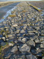
Armored dike - the stones are fixed with bitumen and concrete

Armored dike - stones instead of green lawn

Armored dike - a small wall is also concreted at another point

The stern of the steamer "Kaffraria"

Groyne and measuring tower (scaffolded)


literature
- Graßl, Hartmut: The Tidal Elbe in Climate Change. Does the deepening of the Elbe intensify the consequences? In: Naturschutz in Hamburg, 2007, 2 (Jun./Aug.), Pp. 8-10.
- Bischoff, Sylke: Dredging without compensation - the inadequate compensation of the deepening of the Elbe from 1999 , 1st edition, WWF Germany , Hamburg 2007.
- Fischer, Norbert: In the face of the North Sea - On the history of the dykes in Hadeln , Publishing House of the Landscape Association of the Former Duchies of Bremen and Verden eV, Stade 2007.
- Feldt, Walter: Expert opinion on the plan approval application 'Adaptation of the fairway of the Lower and Outer Elbe for 14.5 m deep container ships' , Hanover 2007.
- Fairway adjustment of the Lower and Outer Elbe for 14.5 m deep container ships - plan documents , project office fairway adjustment, Hamburg 2007.
- Environmental risk assessment and FFH compatibility assessment for projects on federal waterways, further fairway adjustments of the Lower and Outer Elbe to container shipping with a salt water depth of approx. 14.50 m , BfG - 1380, Federal Institute for Hydrology, Koblenz 2004, pp. 1–184.
- Kerner, Martin, Jacobi, Anja: The Elbe deepening of 1999. Actual and forecast effects . 1st edition, WWF Germany, Frankfurt am Main 2005.
Web links
Individual evidence
- ↑ a b Dr. Stephan Mai vorsorge_cuxhaven (PDF; 258 kB)
- ↑ Pedingworth is a district of Neuenkirchen
Coordinates: 53 ° 49 ′ 59.6 ″ N , 8 ° 50 ′ 4 ″ E