
Bederkesaer See
| Bederkesaer See | ||
|---|---|---|

|
||
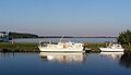
| The Bederkesaer See from afar, autumn 2005 | ||
| Geographical location | District of Cuxhaven , Elbe-Weser triangle , Lower Saxony | |
| Tributaries | Falkenburger Bach | |
| Drain | Ankeloher Randkanal → Mühe → Gösche → Medem | |
| Places on the shore | Bad Bederkesa | |
| Location close to the shore | Bremerhaven | |
| Data | ||
| Coordinates | 53 ° 37 '36 " N , 8 ° 51' 40" E | |
|
||
| surface | 2.15 km² | |
| length | 800 m | |
| width | 1.1 km | |
| Maximum depth | 1.5 m | |
| Middle deep | 1 m | |

The Bederkesaer lake is a Moorsee in North Lower Saxony with an average depth of one meter and approximately 215 hectares, from one-fifth in the eastern part, characterized by a buoy chain is protected.
description
The lake is located near Bad Bederkesa at the foot of the 30 m high Bederkesaer Geestrückens . Due to the shallow depth, the lake tends to silt up . Many birds can be found on the lake, including great crested grebes , black-headed gulls , herons and reed warbler . There is also an old Saxon ring wall near the lake .
The nearby Holzurburg Forest and the circular path around the lake are good hiking options.
The lake is very popular as a fishing area and is also used for professional fishing, as it is rich in eel , perch , bream , pike , carp , rudd , roach , tench , whitefish and pikeperch . Boat fishing is allowed, but night fishing is not. The operator is the Lasner fishing and smokehouse. Motor boats are not allowed to enter it.
Picture gallery
The lake and the Hadelner Canal

The large expanse of water of the lake

Autumn fog on the edge of the Holzurburg nature reserve


See also
Web links
Individual evidence
- ↑ www.anglermap.de: Bederkesaer See water profile (accessed on November 7, 2014)