
Balksee
| Balksee | ||
|---|---|---|

|
||
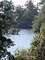
| Balksee, looking east | ||
| Geographical location | District of Cuxhaven , Lower Saxony | |
| Location close to the shore | Hemmoor , Bad Bederkesa , Otterndorf | |
| Data | ||
| Coordinates | 53 ° 41 '53 " N , 9 ° 2' 1" E | |
|
||
| surface | 1.278 km² | |
| length | 2 km | |
| width | 1 km | |
| Maximum depth | 1.5 m | |
| Middle deep | 1.2 m | |
|
particularities |
Geestrandsee |
|

|
||

The Balksee is a 1.278 km² (127.8 ha) lake in the district of Cuxhaven , Lower Saxony .
geography
The lake is located in the district of Cuxhaven near the villages of Bülkau , Stinstedt and Wingst . It is located southwest of the Wingst ridge and north of the Lamstedter Börde . It is part of the nature reserve Balksee and Randmoore / Basmoor and Nordahner Holz .
The Balksee is a Geestrandsee with wide silting zones and a flat moor in the west and a high moor in the northeast. Topographically, the Balksee is a meadow below the water table, corresponding to the Steinhuder Meer . Because the entire area around the lake is very impassable, it is largely beyond the direct local influence of humans. There are around 20 species of ducks and geese on the lake . You can also see numerous birds of prey here .
Inflows and outflows
Tributaries to the Balksee are in the south and east of the lake and are:
- The Remperbach drains the Ellerbruch and the moors of Weißenmoor and Westersode.
- Goldbach drains the area between Westersode and Bröckelbeck.
- Bröckelbeck Bach drains the area around Bröckelbeck.
- The Bornbach drains the north of Varrel and the Falkenberg
- The Varreler Bach drains the south of Varrel and the Falkenberg
- The Varrel Moorkanal drains the south side of Varrel and the Falkenberg
- The Ahrensbach drains the area around the Seemoor, between Nordahn and Mittelstenahe
- Lembeck Bach drains the area between Varrel and Nordahn
- The Stinstedter Canal drains the area between Bovenmoor and Eichofsberg, as well as the north between Mittelstenahe and Stinstedt
In the north of the lake, east of the outflow, is the Seemoor; it is also drained into the Balksee, mainly through the Wingster Laufgraben and the Seemoorgraben and further east through the Waldlaufgraben.
Drains from the Balksee are located in the north of the lake and are:
- The Neuhaus-Bülkauer Canal , through which a large part of the water now flows away.
- The Aue , a former creek that meanders through Bülkau.
The Remperburg
There was another castle on the Balksee, next to that in Neuhaus, which was also intended to consolidate the power of the Bremen bishops. The Remperburg on the river Remper, today accessible via Bröckelbeck or from Seemoor, was a bit remote, but at the same time it was fast on the old military road that led from Bremervörde via Lamstedt , Wingst -Weißenmoor and Cadenberge to Neuhaus. Conversely, a rider was quickly on the march to keep an eye on the “Land Bülkau ”. The castle was protected on three sides by the Balksee and the Remper River and was therefore easy to defend. It was built in 1286 under Archbishop Giselbert . In order to secure the knights Erp von Luneberg and Augustin von Osten as helpers against the marshes, he gave them the castle with various goods from the area in 1301. When exactly this castle was destroyed is slumbering in the books of the Bremen Archdiocese. It no longer played a role long before 1500.
According to various legends, the knights are said to have gone wild and plundered the area more often, purely out of boredom and arrogance. Until one winter, when the castle was not protected on three sides by thick ice and snow and the knights were distracted and drunk after a rich robbery, the Hadler farmers, including the Bülkauer, took the chance to penetrate the castle. The peasants' revenge is said to have been great. Retrieving their stolen belongings was one thing, dragging the castle to the ground was another. The most important thing was that no attempt should ever be made to build a new castle there.
Today this area is in the nature reserve and is no longer officially accessible. Today one could only see the “Hauswurt”, as the vernacular calls the semicircular arch that the Remper river makes in a meadow before it flows into the Balksee. Even today there are still a lot of stones under its sward, remnants of the thick roof tiles and even roof beams. According to statements by hikers who do not adhere to the ban, you can see it in spring from the different colors of the growing grass.
The use

The Balksee was used for tourism until the 1970s, with rowing or pedal boats, as a mud bath with an excursion restaurant or in winter as an ice rink with many grog stalls. The lake and its surroundings have been under nature protection since 1974.
If the Balksee was frozen over by "warm" springs and currents, there were places with no or only thin ice, then the whole area met on the ice up to Otterndorf, Hemmoor and Lamstedt. For the young people and adults this meant at least one lap (approx. 6 km) around the lake with possible stops at the individual stalls that were hurriedly built to stock up on mulled wine, grog, coffee, tea, lilac berries (elderberries) for the children or also to strengthen a bratwurst. To get a “wet”, colloquially for a wet foot, because you broke through the ice, because you dared to go too close to open water or to the reed belt, here the ice took longer to wear, was not dangerous because the lake is a maximum of one meter deep. The very daring use their VW Beetle or their BMW 1802 as a tractor in the harsh winters to pull people on long ropes on ice skates or sledges across the lake, or just to fling. In contrast to the lake, the floodplain, the ditches or the weather, the canal only very rarely froze over because the constant current was too strong to form a continuous ice surface.
In 2005 there is only one small observation tower left. Entering the area, as well as cultivating the surrounding bog areas, is no longer allowed, which is why they become overgrown. There are only a few fishing boats left from the observation tower in summer and hardly any ice-skaters in winter. The lake gradually silts up, the former abundance of fish and thus the food sources of the storks, the newly settled ospreys and many amphibians are steadily decreasing. As the water level was lowered further, the piles on which the houses were built are no longer in the water and rot. They let the walls of the houses tear down. As in many areas of the world, the occasional floods had distributed fertile deposits, here called "Mudde", and thus preserved fertility. Today it is no longer important, so that the peat farmers have largely stopped managing their farms and are doing other jobs.
Myths and legends
- Remper the giant
- The knight of the Remperburg
- How the village of Balk became the Balksee
Picture gallery
The Balksee framed by trees

The Balksee in the backlight

Fishermen on the Balksee

The Balksee in the backlight

The Balksee at dawn


See also
literature
- Heinrich Meyer : The Balksee and its legends . Festschrift "Haduloh" by the men from the morning star of March 30, 1948, p. 9 ff.
Web links
- Water profile Balksee Anglermap.de
Individual evidence
- ↑ a b Nature reserve "Balksee and Randmoore / Basmoor and Nordahner Holz" in the database of the Lower Saxony State Office for Water Management, Coastal and Nature Conservation (NLWKN)
- ↑ Global Net FX (ArcGIS Viewer for Flex). In: www.umweltkarten-niedersachsen.de. Retrieved March 5, 2016 .
- ↑ Eberhard Michael Iba (Ed.): Hake Betken siene Duven. The saga of the Elbe and Weser estuaries (= special publications by the men from Morgenstern , Heimatbund at the Elbe and Weser estuaries . Volume 16 ). 3. Edition. Men from Morgenstern Verlag, Bremerhaven 1999, ISBN 3-931771-16-4 .
- ^ The term Haduloha