Wingst (mountain range)
| Wingst | |
|---|---|
|
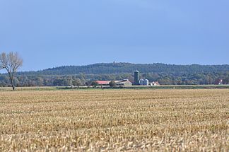
View from the north with the German Olympus |
|
| Highest peak | Silberberg ( 74 m above sea level ) |
| location | in Wingst ; District of Cuxhaven , Lower Saxony ( Germany ) |
| part of | Wesermünder Geest |
| Coordinates | 53 ° 43 '46 " N , 9 ° 3' 24" E |
| Type | moraine |
| particularities | Highest natural elevation in the Elbe-Weser triangle |
The Wingst in the district of Cuxhaven in Lower Saxony is about 74 m above sea level. NHN the highest ridge of the Wesermünder Geest and in the Elbe-Weser triangle . Like the south-southeast neighboring ridge of Westerberg ( 66 m ), with which it forms part of the eastern border of the state of Hadeln , it is a terminal moraine from the Saale Cold Age .
Surname
For the origin of the name Wingst (from the giant Wingis ) see paragraph Sage and mountain name of the article Silberberg (Wingst) .
geography
location
The Wingst is located in the northeast of the district of Cuxhaven, between the Land Hadeln in the west and the Land Kehdingen in the east. It spreads a little south of the mouth of the Elbe in the North Sea and west of the lower reaches of the Oste between Cadenberge in the north and Hemmoor in the southeast. It is about 5 km long in north-south direction and around 4 km wide in east-west direction. The ridge is surrounded by the districts of Wingst . Somewhat south-south-west of it is the Balksee with the Varreler Moor to the east . South-southeast of the Wingst, the landscape leads over to the Westerberg ridge .
Natural allocation
The Wingst belongs to the natural spatial main unit group Stader Geest (No. 63), in the main unit Wesermünder Geest (633) and in the subunit Cuxhavener Geest (633.1) to the natural area Lamstedter terminal moraines (633.10), which also includes the ridge Westerberg in the south-southeast. To the west and south, the landscape slopes gently into the natural area of Stinstedter Niederungen (633.11). To the north and east it slopes gently into the natural area of Land Kehdingen (670.01), which belongs to the main unit group Elbmarschen ( Elbe lowlands ; 67) and the main unit Harburger Elbmarschen (670) to the subunit Stader Marschen (670.0).
Surveys
The Wingst surveys include - sorted by height in meters (m) above mean sea level (NHN):
|
|
The Deutscher Olymp observation tower and the Wingst geomagnetic observatory are located on the German Olympus .
Waters
Numerous short canals drain the north and east of the Wingst to the east and through this to the Elbe estuary. To the south, past the ridge, the Remperbach flows southwest into the Balksee . Its outflow is in particular the Neuhaus-Bülkau Canal , which runs in a north-south direction , into which short canals flow that drain the west of the Wingst.
Protected areas
In the Wingst is located at the German Olympus Nature Reserve Quellental ( CDDA -No 82348;. Reported in 1976, 1.2 ha in size), and in its southwestern foothills pushes the nature reserve Balksee and boundary Moore / Basmoor and Nordahner wood (CDDA No. 555514025;. 2010 ; 15.58 km² ) with the fauna-flora-habitat area Balksee and Randmoore / Basmoor and Nordahner Holz (FFH No. 2220-301; 15.13 km²). The Quellenental , Fahlenberg and Silberberg protected landscape areas are located in the ridge (CDDA no. 323722; 1938; 48.9 ha).
Geology and history
The Wingst is a small geest ridge covered with mixed forests that was formed as an Ice Age moraine . It is surrounded by flat marshland and moorland , some of which are less than a meter above sea level . Within the Wingst located megalithic monuments , such as the close Dobrock located megalithic grave Wingst , refer to early settlement of the area.
Infrastructure
The Wingst can be reached via the federal highway 73 , which touches it in the east , or its side streets as well as the green coastal road , which passes the ridge in the northwest. The Wingst is criss-crossed by the European long-distance hiking trail E9 and regional hiking trails . The zoo is located in the Wingst on the northeast edge of the Wingst .
References and comments
- ↑ a b c d Map services of the Federal Agency for Nature Conservation ( information )
- ↑ a b Height - according to the topographical map of the Wingst mountain range ( memento of the original from February 9, 2016 in the Internet Archive ) Info: The archive link was automatically inserted and not yet checked. Please check the original and archive link according to the instructions and then remove this notice. (DTK 25; see large enlargement of the map), on natur-erleben.niedersachsen.de
- ↑ a b c height - according to unknown / not researched source; Location of the survey unclear
- ↑ height still unknown / not yet researched; Location of the survey unclear
literature
- Walter Umland, Jürgen von der Wense: The Wingst, past and present. Wingst municipality (ed.), 1993.

