Flögelner See
| Flögelner See | ||
|---|---|---|

|
||
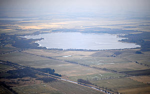
| Flögelner See (aerial photo 2013) | ||
| Geographical location | District of Cuxhaven , Elbe-Weser triangle , Lower Saxony , Germany | |
| Tributaries | Halemer lake outflow from Halemer lake | |
| Drain | Lehe and Flögelner lake drainage, both to the Hadelner Canal | |
| Places on the shore | Fowling | |
| Location close to the shore | Bad Bederkesa | |
| Data | ||
| Coordinates | 53 ° 40 ′ 5 " N , 8 ° 48 ′ 50" E | |
|
|
||
| surface | 1.55 km² | |
|
particularities |
Moor lake |
|

|
||
The Flögelner See is a moor lake about 1.55 square kilometers (= 155 hectares) near the village of Flögeln north of the moor spa Bad Bederkesa in the north of Lower Saxony . There is a water connection to Halemer and to Dahlemer See , both of which are under nature protection.
The lake borders extensive moorland areas in the northeast . There is a small island in the lake where you can see the remains of a medieval moated castle . From a viewing platform on the side of the village you have a good view of the flora and fauna of the lake.
Numerous species of birds nest at the lake and whooper swans come from Northern Europe and Russia in winter .
The southern lake outflow leads over the floodplain to the Hadelner Canal , which is part of the Elbe-Weser shipping route . The lake drain is not navigable, but suitable for paddlers.
The lake is popular as a fishing area as it is rich in eel , perch , bream , pike , carp , rudd , roach , tench , whitefish and pikeperch .


