
Geeste (river)
| Geeste | ||
 Bremerhaven Geestebogen at low tide, with Achgelis bridge and middle motorway feeder |
||
| Data | ||
| Water code | EN : 4992 | |
| location | Elbe-Weser triangle , Lower Saxony and the state of Bremen , Germany | |
| River system | Weser | |
| Drain over | Weser → North Sea | |
| source | at Hof Freitag, community Hipstedt 53 ° 28 ′ 38 ″ N , 8 ° 59 ′ 36 ″ E |
|
| Source height | 20 m | |
| muzzle | in Bremerhaven in the Weser Coordinates: 53 ° 32'9 " N , 8 ° 34'38" E 53 ° 32'9 " N , 8 ° 34'38" E |
|
| Mouth height | 0 m | |
| Height difference | 20 m | |
| Bottom slope | 0.47 ‰ | |
| length | 42.5 km | |
| Catchment area | 338 km² | |
| Left tributaries | Frelsdorfer Mühlenbach, Grove , Seekanal (Sellstedter See) | |
| Right tributaries | Alfgraben, Scheidebach, Bederkesa-Geeste-Kanal , Lavener Sielgraben, Große Beek | |
| Navigable | 25 km | |
The Geeste is a river in Lower Saxony and in the state of Bremen . It flows into Bremerhaven and, according to nautical definitions, is the lowest tributary of the Weser .
geography
The Geeste rises in Hipstedt (integrated community Geestequelle ) in the Rotenburg (Wümme) district ten kilometers west of Bremervörde and drains a large part of the former Wesermünde district (now the Cuxhaven district ). The Geeste is the border river of the city of Geestland .
The source ditches of the river lie at a height of almost 20 meters in the wet grassland area Reisbruch . The hills of the Wesermünder Geest in the eastern part of the Geeste catchment area reach heights of 25 meters. Two kilometers below the source area at Hof Freitag is a symbolic "Geeste spring " on the left. The Geeste flows in the upper reaches through gravel and sand and in the further course through marshland . Trench-like sections alternate with more natural sections. By building sluices, the tidal range was shortened from about 30 km to 5 km.
The lower course of the Geeste represents the western part of the Elbe-Weser shipping route over a length of 25 kilometers and runs straight or in a straight line. In this section of the course, the Geeste meanders only just before the mouth; In the area of the city of Bremerhaven , three of the five river loops previously existed.
Nature on the Geeste
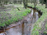
While the lower reaches of the Geeste have been heavily straightened and changed in cross-section to reclaim the river marshes and use them as a shipping route , the upper reaches are largely in a near-natural state. In the source area of the Geeste, which is only 15 m above sea level. The river winds itself idyllically as a still small, partly babbling brook through the narrow floodplain . Black stork , common raven and crane can be found in the densely wooded Geest area . The area is protected as EU FFH area No. 189, the lowlands of Geeste and Grove, as well as the adjacent area No. 197, Malse Forest .
Geeste in Heinschenwalde

Shore wood in the upper Geeste lowlands

Marshland in the lower Geeste valley


In the upper reaches, the Geeste originally had the character of a lowland brook shaped by gravel, whose gravel beds are required by sea trout , for example . These areas can only be found in very few places today. In addition to the construction of the watercourse, the adjacent land use in particular has drastically changed the structure and flow dynamics of the water body and thus also the habitats in and around the stream.
On the other hand, permanent floodplains have been created over the past few years through the demolition of dikes such as in the Polder Bramel (biotope network with Polder Glies and Sellstedter See ), which have created a habitat for many rare species, including the sea eagle .
Hydraulic engineering
The confluence of the Geeste with the Lower Weser , 1.24 km upstream of the nautical border with the North Sea at the Bremerhaven lighthouse , but 19 km upstream of the hydrographic border ( Langwarden - Neufeld line ), is now bordered by two piers .
Storm surge barrier Bremerhaven

The storm surge barrier is only 0.7 km upstream of the estuary. The hydraulic structure was completed just in time for the 1962 storm surge . Otherwise 80% of Bremerhaven would have been flooded via the lower Geestedeiche. In a forecast by the University of Duisburg-Essen published in the EGA series about the flood damage if the Geeste barrage in Bremerhaven fails, it is assumed that 10,860 affected residents with an estimated total damage of approx. 247 million euros.
Bremerhaven tidal barrier

A few meters east of the railway bridge and 5.18 km upstream from the mouth of the Geeste , the tidal barrier with lock was built in the 1960s . It not only has the function of a sewer , but also has a stowage , i.e. H. the upper water is kept at a level of 4.25 m, while the mean low water is just under 3 m. This serves both the navigability of the Elbe-Weser shipping route and the ecology of the Geestemarsch. Because of the low clearance height of the bridge, the official lock times are two hours before and after the high tide.
Schiffdorfer "Stauschleuse"

The so-called Schiffdorfer Stauschleuse is located 9.1 km from the mouth of the Geest in the district of the integrated municipality of Schiffdorf in the district of Cuxhaven . Technically it is neither a dam with Kammerschleuse still a floodgate , but a Sielanlage , so to speak, the oldest Tidensperrwerk in Geeste. It was built between 1890 and 1892 as part of a major melioration and drainage project based on plans by Theodor Hoebel . Ships could only pass the Sielschleuse when the water was running out, if the water level at the mouth of the Geeste was below that of the river section above. Especially during the growing season , it was supposed to protect the marshland of the Geest lowlands from storm surges . Due to its pure sluice function ( without retention ), the water levels in the Geeste and the Bederkesa-Geeste Canal could only be regulated to a limited extent, high water levels prevented at high tide, but not low water levels at low tide. The diminution of the tidal currents caused increasing siltation , which hindered navigation. This created a conflict of interest between agriculture and shipping. The farmers demanded low tides, the boatmen, at least at high tide, high water levels. Only the construction of the tide barrage in connection with the expansion of the Geeste, the Bederkesa-Geeste Canal and the Hadelner Canal in the 1960s brought relief. The Schiffdorfer "Stauschleuse" lost its function in 1961 and was finally shut down in 1967. It is preserved as a technical monument . The lock keeper's house served as an excursion restaurant for decades. The lock keeper Claus Meyn, who ran the restaurant “Zur Stauschleuse”, lived in the modern extension. The historic bridge over the lock had to be replaced by a wooden bridge in 1985. The steel mill railing was reused. The lock has four pillars and three 8 m wide openings with pairs of steel mitred gates. Until 1999 it was restored with the level station.
Geeste bridges in Bremerhaven
.jpg)
- Federal motorway 27
- Bremerhaven – Cuxhaven railway line
- Stresemannstrasse , formerly Bundesstrasse 6
- Bundesstrasse 212 , Grimsbystrasse
- Achgelis bridge at the naval operation school , see Geestemünder Bahnhof # branch line to Bremerhaven
- Old Geeste Bridge
- Kennedy Bridge
Border river
Until the loss of the Lehe court and the Bederkesa office by the Free Imperial City of Bremen to the Swedish Duchy of Bremen in the First Bremen-Swedish War in 1654, the Geeste formed the southern border of these city-Bremen possessions.
Of the restructuring of the Hanoverian administrative divisions by Prussia after 1866 until the merger of the circles Lehe and Geestemünde the district Wesermünde 1932 was the Geeste river that separates the two. And until Bremerhaven was annexed to the city of Wesermünde in 1939, it was the southern border of Bremerhaven. Today it separates the Bremerhaven district of Geestemünde from the districts of Mitte and Lehe .
Web links
- Geeste river landscape on the website of the BUND Landesverband Bremen
- Canoe rental for Lune and Geeste
Individual evidence
- ^ Topographic map 1: 25000
- ↑ Measurement in the TK25
- ↑ Ingenieurgemeinschaft Agwa GmbH: Summary and balancing - flowing water: Frelsdorfer Mühlenbach (compensation measure as part of a water law approval procedure for the Bremerhaven offshore terminal) 2012, accessed on October 27, 2014
- ↑ Back dike Polder Glies. Retrieved April 10, 2019 . (BUND State Association Bremen)
- ↑ Essen Geographical Works
- ↑ Tide barriers
- ^ A b BUND Bremen: Geeste project. → Project report (PDF; 2.3 MB)
- ↑ Dirk Peters : 125 years of the Schiffdorfer floodgate. A technical monument to the history of hydraulic engineering in the Elbe-Weser triangle . In: Men from the Morgenstern Heimatbund at the mouth of the Elbe and Weser. V. (Ed.): Niederdeutsches Heimatblatt . No. 817 . Nordsee-Zeitung GmbH, Bremerhaven January 2018, p. 1–2 ( digitized version [PDF; 5.4 MB ; accessed on July 2, 2019]).
- ↑ Responsible was a development association under the leadership of the architect Olaf Vosshans.