
Sellstedter See and Ochsentriftmoor / Wildes Moor
|
Sellstedter See and Ochsentriftmoor / Wildes Moor
|
||
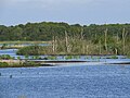
 Aerial view of the Sellstedter See and Ochsentriftmoor |
||
| location | East of Bremerhaven , Cuxhaven district , Lower Saxony | |
| surface | 754 ha | |
| Identifier | NSG LÜ 106 / NSG CUX 005 | |
| WDPA ID | 165555 | |
| FFH area | 520 ha | |
| Geographical location | 53 ° 32 ' N , 8 ° 43' E | |
|
||
| Sea level | from -0.6 to 3 m | |
| Setup date | December 16, 1984 | |
| administration | NLWKN | |
| particularities | The approximately 40 hectare Sellstedter See is located in the nature reserve. | |

Sellstedter See and Ochsentriftmoor / Wildes Moor is the name of a nature reserve in the Lower Saxony municipality of Schiffdorf in the Cuxhaven district .
description
The nature reserve is 754 hectares in size. The FFH area “Sellstedter See and Ochsentriftmoor” forms part of the nature reserve .
The nature reserve lies between Schiffdorf in the west, Bramel in the north and Sellstedt in the south. It includes the Sellstedter See, parts of the Ochsentriftmoors and the Wilder Moores and the Polder Glies .
The Sellstedter See is a naturally formed bog lake as a result of the subsidence of the peaty subsoil as moor water banks. It is separated from the surrounding areas by a dike and partially functions as a flood compensation basin for the Geeste , to which it is connected via the sea canal. The lake is surrounded by a wide belt of reeds and reed beds, as well as grassland , tall herbaceous meadows and swamp forests . He shows clear Verlandungs trends, the nutrient-rich water from the influx of Geeste during the closing hours of the Tidesperrwerks in Bremerhaven to be strengthened.
To the west and south-west of the Sellstedter See there are high moor areas. In the Ochsentriftmoor there are still near-natural moor areas with birch-pine-moor forests, moor heaths , swinging lawns and peat swamps . The areas in the wild moor are mainly used for agriculture as grassland. Further grassland areas can be found in the edge areas of the Ochsentrift moor.
To the east of the nature reserve is the approximately 85-hectare Polder Glies, a high-water polder with shallow water areas on the edge of the Geeste valley, which was created in autumn 2006 as a compensatory measure for the construction of the Luneplate industrial area in Bremerhaven. For this purpose, the formerly heavily drained area was taken out of use and the dike to the Sellstedter See was relocated to the east. The polder has developed into an important breeding and resting area for waders and water birds .
To the north-east of Bramel there is another high-water polder, the Polder Bramel , which was designed to be close to nature as early as 1994, but is not under nature protection. The Polder Glies, together with it and the Sellstedter See, form a biotope network .
Between the Polder Glies and the Sellstedter See there is an observation tower that can be used for nature observation. Another observation tower is located in the south of the Bramel polder.
The area that is drained to the Geeste via the See Canal, the Ollen and the Brameler Randgraben has been a nature reserve since September 17, 2010. The 520 hectare former nature reserve “Sellstedter See and Ochstentriftmoor”, designated in 1984 as NSG LÜ 106, has been incorporated into the nature reserve. The responsible lower nature conservation authority is the district of Cuxhaven, which manages the nature reserve under the registration number NSG CUX-005.
Picture gallery

Nature reserve "Sellstedter See and Ochsentriftmoor / Wildes Moor"

View over the Polder Glies to the Sellstedter See
Rewetted area in the Polder Glies

South-east edge of the Sellstedter See


See also
Web links
- Nature reserve "Sellstedter See and Ochsentriftmoor / Wildes Moor" in the database of the Lower Saxony State Office for Water Management, Coastal and Nature Conservation (NLWKN)
Individual evidence
- ^ Sellstedter See and Seekanal , BUND-Landesverband Bremen. Retrieved May 14, 2019.
- ^ Back dike Polder Glies , BUND-Landesverband Bremen. Retrieved May 14, 2019.


Ahlen-Falkenberger Moor, Halemer / Dahlemer See | Ahlershorst | At the Flögelner See | Aßbütteler Moor | Balksee and Randmoore / Basmoor and Nordahner Holz | Bargsmoor / Rechtenflethermoor | Borner Moor | Bülter See and Randmoore | Dorumer Moor | Extensive pastures north of Langen | Stain wood | Geest lowlands | Grove low | Hadelner and Belumer outer dyke | Hahnenknooper Moore | Heath and moor near Haslah | Behind the trough in the Flögelner wood | Hohensteinsforst | Holzurburg am Bederkesaer See | Huuss im Flögelner Holz | In the Hausbeeken | Klinten | Kuhlmoor and Tiefenmoor | Long Moor | Rent moor | Oederquarter Moor | East loops | Baltic Sea | Eastern Malse | Quellenental | Ringstedter See | Sellstedter See and Ochsentriftmoor / Wildes Moor | Silbersee and Laaschmoor | Gorse heather in Nordholz | Southern Hagen Königsmoor | Tideweser | Lower Oste | Wanhödener Moor | Westerberg and upper Hackemühlen Bachtal | Wild moor near Stinstedt | Windbracken wood | Wollingster See and Randmoore