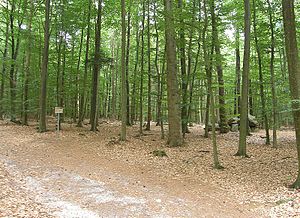
Westerberg and upper Hackemühlen Bachtal
|
Westerberg and upper Hackemühlen Bachtal
|
||
|
Wald am Steenaben in the NSG |
||
| location | Between Hemmoor and Lamstedt in Lower Saxony Cuxhaven | |
| surface | 218 ha | |
| Identifier | NSG LÜ 293 / NSG CUX 012 | |
| WDPA ID | 555552571 | |
| FFH area | 189.4 ha | |
| Geographical location | 53 ° 40 ' N , 9 ° 5' E | |
|
|
||
| Setup date | August 24, 2012 | |
| administration | NLWKN | |
The Westerberg and Upper Hackemühlen Bachtal is a nature reserve in the municipality of Lamstedt in the joint municipality of Börde Lamstedt in the district of Cuxhaven .
The nature reserve with the sign NSG LÜ 293 is 218 hectares . It is almost congruent with the FFH area "Westerberge bei Rahden".
The nature reserve is north of Lamstedt. It places part of the forested Westerberg in the north with the source streams of the Hackemühlen Bach and the upper Hackemühlen Bachtal under protection. In the southeast of the nature reserve there are large areas of agricultural land.
The nature reserve is characterized in the north by a forest area on the Westerberg, a terminal moraine from the Saale Cold Age . The forest area is predominantly dominated by Douglas fir and spruce forests. Mixed oak forests with transitions to beech and oak-hornbeam forests are embedded in the forest area .
The Hackemühlen Bach rises within the nature reserve. It initially flows in a south-easterly direction and is fed by numerous seepage springs on the slopes of the Westerberg. The Bachtal is under protection up to the federal highway 495 between Lamstedt and Hemmoor . Within the nature reserve, the Hackemühlen Bach mostly flows naturally. It has a sandy, partly gravelly and stony bottom . The course of the stream is accompanied by trees and bushes typical of the floodplain .
In the flat slope areas of the Westerberg in the southeast of the nature reserve, grassland predominates, which is structured on a small scale by field and wall hedges . A few areas are also used as arable land. The grassland is predominantly mesophilic or moisture grassland , a small area is also orchid rich wet grassland, sedges - and rushes rich flood lawn and Nardus grasslands to find.
The area has been under nature protection since August 24, 2012. The responsible lower nature conservation authority is the district of Cuxhaven.


