Eastern Malse
|
Eastern Malse
|
||
| location | Northwest of Basdahl in Lower Saxony Cuxhaven | |
| surface | 78 ha | |
| Identifier | NSG LÜ 137 / NSG CUX 008 | |
| WDPA ID | 164965 | |
| FFH area | 78 ha | |
| Geographical location | 53 ° 28 ′ N , 8 ° 58 ′ E | |
|
|
||
| Sea level | from 18 m to 44 m | |
| Setup date | December 21, 1985 | |
| administration | NLWKN | |
The Eastern Malse is a nature reserve in the Lower Saxony municipality of Beverstedt in the district of Cuxhaven .
The nature reserve is 78 hectares in size. It is practically congruent with the FFH area "Malse". The area has been a nature reserve since December 31, 2010. The 51 hectare former nature reserve of the same name, designated in 1985 and designated NSG LÜ 137, has been incorporated into the nature reserve. The responsible lower nature conservation authority is the district of Cuxhaven, which manages the nature reserve under the registration number NSG CUX-008.
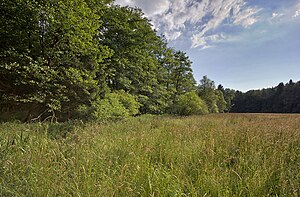
The reserve represents the eastern part of the south-west of Hipstedt lying forest area "Malse" under protection. Near-natural forest stands predominate in the nature reserve. You can find oak-hornbeam forest , angular sedge and Milzkraut-alder-ash forest and alder quarry forest . In the nature reserve spring headwaters of Lune .
The route of the planned A 20 coastal motorway between Westerstede and Drochtersen runs only a few hundred meters north of the nature reserve.
Web links
- Nature reserve "Eastern Malse" in the database of the Lower Saxony State Office for Water Management, Coastal and Nature Conservation (NLWKN)
Individual evidence
- ↑ Overview map A 20 from Westerstede to Drochtersen, Sections 4 + 5 , Road Administration of the State of Lower Saxony, February 13, 2014 (PDF file, 3 MB). Retrieved March 23, 2016.


